


EBC Cho La Pass Gokyo Trek Cost
| Group Size | Price in USD |
| 1 Person | $1800 |
| 2-4 Person | $1550 |
| 5+ Person | $1450 |
The Everest Base Camp Cho La Pass Gokyo Trek is an extensive 15-day itinerary designed for hikers who want a fully supported mountain experience but prefer to handle their own city logistics in Kathmandu. While a standard Everest Base Camp Trek is a rewarding route on its own, adding Cho La Pass and the Gokyo Lakes turns the trip into a much larger, more challenging, and complete loop.
This route takes you far beyond the busy main trails through the Khumbu region and Sagarmatha National Park, a UNESCO World Heritage Site. You will stand at the foot of the world’s highest peak at Everest Base Camp (5,364 m), climb over the icy Cho La Pass (5,365 m), and walk alongside the pristine waters of the Gokyo Lakes in the Gokyo Valley. In between, you will watch the sunrise from Kala Patthar and climb the Gokyo Ri viewpoint for panoramic views of Everest, Lhotse, Makalu, and Cho Oyu.
Because the trek is a physically demanding route and one of Nepal’s most rewarding high-altitude adventures, this package by Radiant Treks covers all your mountain logistics. They include Lukla flights, local permits, and teahouse bookings, allowing you to focus purely on the climb.
Why Choose The 15-Day Trek-Only Package?
Trekking to EBC, crossing Cho La Pass, and reaching Gokyo Lakes is physically exhausting. If you have to manage unpredictable mountain logistics on your own, then the journey becomes a hassle. Choosing to trek with Radiant Treks means you can fully enjoy the adventure while we solve your problems.
This 15-day package strips out the Kathmandu hotel costs and focuses entirely on getting you safely through the Himalayas. Here is exactly what we handle for you:
- Lukla Flight Management: Flying into Lukla’s Tenzing-Hillary Airport is notorious for weather delays. We take care of the ticket bookings and monitor the schedules. If the government suddenly reroutes flights to Ramechhap Airport, we handle all the last-minute changes so you don’t have to worry about them.
- Zero Permit Stress: We obtain your mandatory Sagarmatha National Park Entry Permit and local municipality permit before you hit the trail.
- Built-in Acclimatization: Going over 5,000 meters is dangerous if rushed. We strictly enforce two active rest days (in Namche Bazaar and Dingboche, including a hike to Nangkartshang Hill) to let your body safely adapt to the thin air.
- A Complete Loop: Instead of walking up and down the same trail, we guide you on a massive, varied circuit through the wider Everest region, supported by seasoned local experts.
Note: Because this is a trek-only package, hotel stays in Kathmandu before Day 1 and after Day 15 are not included. It means you have the freedom to choose your budget or luxury accommodation when in Kathmandu.
Difficulty & Trail Conditions: Is Cho La Pass Dangerous?
To be completely upfront, the Everest Base Camp Cho La Pass Gokyo Trek is very strenuous. It is considered one of Nepal’s most challenging teahouse treks. While standard EBC is achievable for most fit hikers, crossing over to the Gokyo Valley introduces rugged, technical variables. You do not need to be a mountaineer, but you must be prepared for the following realities:
- Thin Air: You will spend several days sleeping above 4,000 meters and hiking above 5,000 meters during this high-altitude trek. Oxygen levels here are roughly 50 percent of what they are at sea level.
- The Cho La Pass Crossing (Day 10): This is a grueling seven-to eight-hour day climbing up to 5,365 meters. You will scramble over large boulders and walk across a glacier crossing. Depending on the season, the ice on the trail can be slippery. As such, it requires you to use microspikes.
- Long Descent Days: Days 13 and 14 involve long walks (up to 19 km on the final push to Lukla), which will heavily test your knees and overall endurance.
- Freezing Temperatures: After you pass Dingboche, the mountain chill really sets in. The nights routinely plunge to -15°C, so having a top-tier sleeping bag and serious warm layers is the only way you are going to get any sleep.
Accommodation & Meals on the Trail
During your 14 nights on the trail, you will sleep and eat in traditional mountain teahouses on this classic teahouse trek in Nepal. While the lower Everest region has some of the best trekking infrastructure in the world, be prepared for comfort levels to drop significantly as your altitude increases.
- The Lodges: Lower down in Phakding and Namche Bazaar, teahouses often feature heated dining rooms, flush toilets, and hot showers. Once you cross into Dzongla and Gokyo, rooms become basic, uninsulated plywood spaces with shared squat toilets.
- Gear Requirement: Because teahouse bedrooms are unheated, a high-quality sleeping bag rated for at least -20°C is essential for surviving the freezing nights.
- Food and Diet Safety: Your primary fuel on the mountain will be traditional Nepali dal bhat (a hearty meal of rice, lentil soup, and vegetable curry). It is the best value on the trail because it comes with unlimited refills to power your massive 15 to 19 km hiking days.
- The Golden Food Rule: While lower villages offer extensive menus, we highly recommend sticking to a strict vegetarian diet once you pass Tengboche. Meat is carried up the mountain on foot for days without refrigeration, making it the leading cause of stomach bugs that ruin treks. Stick to eggs, lentils, and yak cheese for your protein.
Getting to Lukla: The Transportation
Your trek begins by flying into Lukla’s famous Tenzing-Hillary Airport. Here is how that works:
- Standard Flights: We include your round-trip tickets. Just a heads-up: these tiny planes need perfect weather to land, so delays are basically part of the adventure.
- The Ramechhap Detour: During the busy spring and fall seasons, flights often shift to Ramechhap’s Manthali Airport to ease Kathmandu’s air traffic. This means taking a four-hour midnight drive to catch your morning takeoff.
- Helicopter Upgrades: Prefer to skip that exhausting midnight drive and dodge most weather delays? You can upgrade to a shared helicopter straight out of Kathmandu, paying an extra amount.
Guides, Porters & Group Types
- Your Guide (Included): You shouldn’t be guessing your way across glaciers or predicting the weather at Cho La Pass. The licensed trekking guides in Nepal handle the navigation, carry medical kits, and monitor your pace. If an emergency happens, they manage the rescue protocols.
- Porters (Highly Recommended): Lugging a heavy backpack above 5,000 meters is brutal. While optional, hiring an Everest trekking porter is the best investment you can make. It lets you hike with just a light daypack, making the grueling pass crossing much safer and far more enjoyable.
- Who is this trek for? We offer group departures for solo travelers who want to meet others. Radiant Treks runs private treks as well, suitable for couples, families, or friends. This package is perfect if you want to handle your Kathmandu hotels but need premium support in the mountains. This makes it an excellent choice for trekkers looking for a fully supported Everest trekking experience.
Why Book The EBC-Cho La Pass-Gokyo Trek With Radiant Treks?
- You’ll be trekking with a company founded by Gokarna Khanal, who brings two decades of firsthand experience from his early days as a porter.
- We handle all the stressful logistics for you, including domestic Lukla flights, airport pickups, and necessary road transfers.
- Pack light and save some cash—we'll lend you a sleeping bag, down jacket, and duffel bag for the trip.
- You're staying 14 nights in warm, local teahouses, getting three solid meals a day and fresh fruit each evening.
- Trek worry-free with our English-speaking guides. They carry full medical kits, and we have a 24/7 rescue team on standby.
- We handle all the tedious paperwork, including your permits and local taxes, so that you have the freedom to just focus on exploring safely.
- We always ensure that our local experts receive fair pay for their hard work.
- We focus on highly personalized service that really connects you with the local culture.
- You will head home with a custom route map and an official certificate to remember your adventure.
Everest Base Camp Cho La Pass Gokyo Trek Detailed Itinerary
Flight Duration: 30 to 35 minutes
Flight Distance: 136.17 km
Maximum Altitude: 2860 m above sea level
Trek Duration: 3 to 4 hours
Trek Distance: 8 km
Maximum Altitude: 2610 m above sea level
The Everest Base Camp via cho la pass expedition starts with a Kathmandu departure to Lukla during early morning flights. Flying for a brief period provides exceptional views of Himalayan peak ranges until aircraft reaches the dramatic airspace located on a mountainside.
Local shops combined with guideline services and porter assistance greet travelers in Lukla when they arrive at this lively foothold territory. The group begins the Phakding journey following organization and preparation of equipment and a warm drink.
Through attractive Sherpa villages the trail gradually descends while showing mani stones with Buddhist prayers and prayer flags hanging from the chortens. You find snow-covered peaks in between trees of the pine forests that line the walking path.
We cross suspension bridges during the trail because these bridges move over the fast-flowing river. The pace of this path is comfortable since travelers can both appreciate the peaceful sights and acclimatize to the higher altitude. By late afternoon at Phakding most trekkers can find comfortable accommodations in teahouses while receiving greeting service and satisfying dining options.
The night consists of easygoing relaxation and thinking back on today’s excursions with preparations for the upcoming obstacles.
Trek Duration: 6 to 7 hours
Trek Distance: 10 km
Maximum Altitude: 3440 m above sea level
Trekking participants start day two with early breakfast since the trip to Namche Bazaar demands considerable climbing effort. The path runs parallel to Dudh Koshi River until trekkers must navigate across multiple hanging bridges that feature prayer flags. In this path you pass through thick pine forest while seeing Sherpa way of life in their small communities. The walking route features both prayer wheels and Mani walls that enhance its spiritual character.
We are required to present our permits at Monjo where Sagarmatha National Park begins before continuing the challenging rocky path. The challenging slope steepens more and requires determined physical strength to continue. The path becomes thinner while trekkers receive exceptional views of Thamserku and Kusum Kanguru.
The sight of Mount Everest in the distance from a distant ridge point becomes both the reason and the motivation for trekkers to conquer the challenging ascent. Namche Bazaar emerges as a view from the diligent uphill hike which is located inside a natural amphitheater formation.
The town presents itself as a lively center filled with shops and markets that offer both modern comforts and busy establishments. We recover at lodges by consuming hot dishes and contemplating their successful exploration.
Trek Duration: 3 hours
Trek Distance: 5.4 km
Maximum Altitude: 3,962 m above sea level
Acclimatization at high altitude conditions takes place during the third day stop in Namche Bazaar. In Namche Bazaar we can choose to take a brief trail from their base to reach the famous Everest View Hotel where they can observe outstanding views of Mount Everest alongside Lhotse and Ama Dablam.
The trail advances moderately while crossing Syangboche before following a ridge that provides stunning views. From the viewpoint trekkers receive breathtaking views of snow-capped mountains which tower gracefully against the stunning blue sky.
We conclude our view-understanding experience of Namche by returning back to Namche Bazaar. Travelers can explore Namche Bazaar at their leisure during the afternoon hours. You can spend their time at the Sherpa Museum exploring mountaineering heritage and local traditions besides enjoying the active marketplace stocked with traditional goods and souvenirs.
You can find various cozy cafes together with bakeries within Namche Bazaar that offer ideal spaces to relax while exchanging stories with other trekking companions. On this day explorers engage in active pursuits while also taking time for rest since proper adjustment before climbing to elevations at higher altitudes must occur.
A second overnight stay in Namche Bazaar enables the body to adapt to lower pressure air conditions, minimizing the chance of altitude sickness. People who participate in this mandatory cultural event experience both physical adjustment and alignment with a culturally rich environment.
Trek Duration: 5 to 6 hours
Trek Distance: 9.2 km
Maximum Altitude: 3860 m above sea level
The trail moves upward from Namche Bazaar toward Everest and Lhotse and Ama Dablam while showing spectacular views of these peaks. The stunning trail follows the mountainside while woods of rhododendrons and pine trees surround it. The trail descends to meet the Dudh Koshi River while passing through small villages that provide rest and supply stations such as tea houses.
Proceeding over the suspension bridge leads trekkers to an intense climb that reaches Tengboche. Thanks to rewarding views of soaring peaks, people maintain their high spirits during this difficult ascent.
The trail gradually smooths out after numerous hours of climbing to expose the biggest religious place in Khumbu at Tengboche Monastery. Ama Dablam forms the astonishing background behind Tengboche Monastery with its gold-clad spires and its prayer flags displaying distinct colors. Sharpened mental readiness enhances when you visit the monastery and observe the monks performing their prayer rituals addressing their spiritual depth.
From this location we get unobstructed mountain views that include a significant perspective of Everest. Evening sunlight creates a magical scene when it illuminates the peaks covered in snow while turning their surfaces into rich shades of gold and pink. The monastery exploration ends with trekking groups finding rest in local tea houses while enjoying food and contemplation about their daily trek among the tranquil location.
Trek Duration: 5 to 6 hours walk
Trek Distance: 9 km
Maximum Altitude: 4410 m above sea level
Tengboche receives golden illumination during sunrise when Ama Dablam displays its magical appearance. After breakfast the route drops into a forest of rhododendron and pine trees which echoes with Himalayan bird sounds. Along the path lies a sturdy suspension bridge which crosses the Imja Khola River before reaching Pangboche Village at the highest elevation for permanent inhabitants in this area.
At Pangboche Monastery, we can explore the place which showcases Sherpa cultural heritage together with monk history.
The elevation transforms the environment when it passes the tree line which reveals extensive meadows with challenging mountainscapes. The trail reveals amazing views because it circles around Lhotse and Nuptse together with Ama Dablam and Kangtega. Thinner air conditions become noticeable at this time during the altitude rise and trekkers need to adjust their pace appropriately.
The route extends until it reveals Dingboche situated directly below the south of Ama Dablam. Stone-walled fields together with stone houses give the town its original rustic appeal which has been retained throughout the years. We find comfort and relaxation at tea houses where they eat hearty food and rest their tired bodies.
We could also opt for star-gazing at night when the Milky Way lights up the Himalayan peaks above Dingboche, creating a once-in-a-lifetime experience.
Hike Distance: 5.3 km
Maximum Altitude: 5083m above sea level
Breakfast begins the day which leads to a short hike up Nangkartshang Hill. The path from Dingboche rises sharply to reveal clear perspectives of Cho Oyu and Makalu and Ama Dablam peaks. Trekkers must make multiple stops during the steep climb because the altitude makes the ascent challenging though it lets them take in the stunning vistas.
Going higher up through this trail results in decreasing air pressure and cooling temperatures which adds difficulty to the trek. The elevation point stands at 5,083 meters where hikers can enjoy endless views of the Himalayas reaching across multiple directions. Toward achieving this goal and witnessing this magical landscape makes all the hardship seem trivial. The view-segment comes to an end before we start descending to Dingboche.
The hike back takes a shorter amount of time that provides us with enough time to visit the village. The local bakeries in the area offer fresh pastries and can allow us to interact with fellow adventurers while sharing stories and experiences. The rest of the day serves to help the body adapt to altitude conditions which minimizes health risks during future altitude rises.
Trek Duration: 6 to 7 hours
Trek Distance: 10.7 km
Maximum Altitude: 4940 m above sea level
Travelers from Dingboche ascend on a gradual course through a valley with powerful peaks at Taboche and Cholatse. The path grows higher step by step while you gain stunning perspectives of the Himalayan mountain peaks covered in snow. From the flower-covered meadows of Dingboche the terrain shifts into an arid and challenging terrain of rising altitude.
The thinner atmosphere creates great difficulty for each stride but the spectacular landscape keeps us moving forward. You later reach Thukla and take a rest after an approximately two-hour walk for refreshments in this small settlement. The track ascends progressively until it reaches the Thukla Pass region. The path in this section poses substantial challenges from the demanding rocky climb that demands serious endurance and strong determination.
The summit of Thukla Pass features an important memorial structure that honors the climbers who perished during summit attempts on Everest. Prayer flags scatter the area while stone cairns create a reflective space that blends respect with forestry mountains. The path proceeds along the Khumbu Glacier’s glacial moraine where you can admire Pumori, Lingtren together with Khumbutse peaks.
The trail leads further to Lobuche village where you use simple teahouses for rest and preparation before the trip to Everest Base Camp.
Trek Duration (Gorakshep): 4 to 5 hours
Maximum Altitude (Gorakshep): 5164 m above sea level
Hike Duration (Everest Base Camp): 2.5 to 3 hours
Maximum Altitude (Everest Base Camp): 5364 m above sea level
Total Trek Distance: 15 km
Along the trail from Lobuche we trek at the Khumbu Glacier edge as we pass numerous lofty mountains while traversing difficult terrain to reach Nuptse and Pumori. The rocky terrain with uneven surfaces requires us to move with care and maintain a steady movement pace.
Traversing through the landscape for some hours brings us to Gorak Shep which marks the endpoint before reaching Everest Base Camp. We use Gorak Shep as our pause and recharging point to discard heavy baggage and prepare for the Base Camp expedition.
Everest Base Camp route contains glacial moraine as its pathway which leads us through paths filled with rock and ice. Oxygen is scarce in the thin atmosphere and makes it difficult to breathe yet the proximity to the famous base camp generates positive excitement. As we steady the pace for several hours we finally spot the colorful tents of Everest Base Camp standing against impressive ice walls and near the intimidating Khumbu Icefall.
The feeling of accomplishment takes over since you will be over 5,463 meters above sea level. Everest’s summit remains out of sight from the base camp yet the energy level remains high because numerous mountaineers gather to challenge the peak. We end our day at Gorak Shep before spending the night in preparation for tomorrow’s adventure.
After the tiring hike we get an incredible joy before resting the night while preparing for Kala Pattha before dawn.
Trek Duration (Kala Patthar): 2 to 3 hours
Trek Distance: 1.2 km
Maximum Altitude: 5643 m above sea level
Trek Duration: 5 to 6 hour
Trek Distance: 10 km
Maximum Altitude: 4830 m above sea level
Early in the morning we start our climb up to Kala Patthar so we can witness one of the greatest Himalayan sunrises. Climbing Kala Patthar becomes difficult because of its steep terrain and rocky path under cold weather conditions. High-altitude air thinness creates excessive fatigue during each step yet the awaiting vision ahead keeps us moving forward.
The summit at 5,643 meters offers a surreal experience as the sun brings its first light while we stand there. A succession of golden sunlight shines upon Everest and Nuptse and Lhotse to produce an extraordinary view. Observing the Himalayan peaks from Kala Patthar provides visitors with the most complete wide view of Everest summit along with neighboring mountain giants.
We start our way back to Gorak Shep following photo shooting and sightseeing at the location. Our group moves forward from Gorak Shep after taking breakfast to reach Dzongla. The path begins by descending gradually at first which allows visitors to leave ice deserts behind before entering narrow stone valleys surrounded by snow peaks. During this path, fewer visitors create a peaceful environment for meditation and contemplation.
While trekking through rugged terrains and ridges we behold the dominant presence of Cholatse facing us toward the sky. The path toward Dzongla presents an attractive route which becomes physically challenging because of its steep terrain. At Dzongla we spend the night in one of the few teahouses that provide basic services before tackling Cho La Pass.
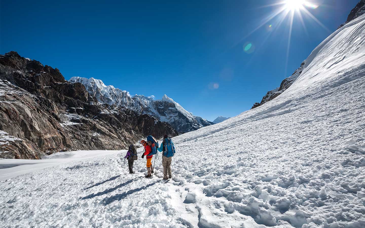
Trek Duration: 7 to 8 hours
Maximum Altitude: 4650 m above sea level
The tenth day ranks among the highest difficulty levels for trekking because we must brave the dangerous Cho La Pass. The day starts in the morning from Dzongla to prevent dangerous afternoon weather that could increase the risk of crossing the Cho La Pass.
The path initiates a soft elevation followed by rocks and elevated mountain peaks that circle the area. The way to Cho La Pass base becomes increasingly difficult because trekkers need to step carefully around loose rocks and icy terrains.
Trekking to Cho La Pass requires an intense climb because trekkers need to cross a glacier along the way. Reaching at 5,420 meters presents an amazing wide view of peaks that includes Ama Dablam and Cholatse. The mountainous expanse of ice and rugged rocks alongside the expansive views produces a stunning detached world environment.
The descent from the magnificent views starts from there. Slow and cautious descending steps are necessary because the downhill path consists of steep rocky terrain. The gentle descent in the trail connects with the glacial valley which encompasses mountain peaks covered in snow. We finally have a rest at Tagnag which represents a tiny settlement with essential teahouses after finishing a tiring yet sensational day.
Trek Duration: 2.5 to 3 hours
Maximum Altitude: 4790 m above sea level
The hike from Tagnag to Gokyo offers short distances with smoother trails after the challenging day behind. The path runs alongside Ngozumpa Glacier which represents the longest glacier in Himalayan territory. The pathway consists of rocky terrain combined with glacial moraines while trekking we get to see stunning peaks all around them.
Trekking across this area presents a fair challenge due to its rocky nature while providing delightful views of the surrounding scenery during altitude adjustment. The shimmering turquoise waters of the Gokyo Lakes appear through the rocky terrain after traveling a few hours.
We will be using teahouses at Gokyo as base as we proceed to discover the local area. Going to Gokyo, you must make time to see the Fourth Lake because its deep blue waters create a delightful and peaceful atmosphere. Traveling to the Fourth Lake requires following a gentle uphill path through landscapes which present magnificent sights of Cho Oyu, the six-highest mountain globally.
The reflection on the Fourth Lake surface perfectly reflects the surrounding snow covered peaks into an ideal amazing view. We spend the evening back in the settlement of Gokyo after appreciating the peaceful surroundings and capturing beautiful photographs at their destination. You finish the day by feasting and relaxing before waking up early for Gokyo Ri tomorrow.
Trek Duration (Gokyo Ri): 4 to 5 hours
Maximum Altitude (Gokyo Ri): 5360 m above sea level
Trek Duration (Dole): 5 to 6 hours
Maximum Altitude: 4200 m above sea level
We start the difficult mountain hike in the dawn to Gokyo Ri which provides breathtaking scenery that ranks as a top viewpoint in the Everest area. The challenging ascent follows a zigzagging path along the hills that becomes more difficult as both the air gets thinner and the temperatures drop. You need to take regular breaks while struggling with this tough ascent because their expectation of the expansive wide view motivates them.
At 5,360 meters, you are rewarded with a majestic view of Everest and three other world-highest peaks, Lhotse, Makalu, and Cho Oyu. As the sun rises golden the tall mountains become illuminated with warm colors creating an undeniably extraordinary fantastical experience.
A safe yet quick hike leads from the viewing point at Gokyo to continue the descent while you maintain caution. The trip advances to Dole after a short breakfast break and brief relaxation period. The descent follows a gentle path which returns through Ngozumpa Glacier’s edge until reaching grazing areas filled with yaks in alpine meadows.
Moving through this path becomes easier because the air grows denser while the trails pass through forests where rhododendron and juniper dominate the vegetation. Once in Dole we can rest at welcoming tea houses while savoring delicious meals and reflecting the day’s moments.
Trek Duration: 4 to 5 hours
Maximum Altitude: 3440 m above sea level
On Day 13 we move downwards through dense greenery while making our way from Dole to Namche Bazaar. The path traverses rhododendron and juniper forest areas while Himalayan birds continuously voice their songs. The downhill slope is easy since you can maintain a steady walking speed to watch the beautiful valley scenery spread below.
The turning trails on the hillside periodically expose sensational peak views that include Thamserku and Ama Dablam mountains.
We will be stopping at Phortse Tenga in the picturesque villages and find refreshment spots at local tea houses. The trail takes a light climb towards Namche Bazaar before uniting with the principal trail leading to Namche Bazaar. We need to cross walking bridges across streaming rivers situated around towering cliffs and dripping waterfalls.
The atmosphere warms up combined with increased oxygen density generates a relaxed atmosphere that offsets the demanding hikes of high elevations. A horseshoe-shaped valley encompasses Namche Bazaar until it finally becomes visible along the trail approach.
After finishing the difficult high-altitude loop we achieve a feeling of satisfaction upon reaching Namche Bazaar. Exploration of busy markets combines with sitting in warm cafes and marking a completion of the expedition foundations during nighttime activities.
Trek Duration: 6 to 7 hours
Trek Distance: 17.7 km
Maximum Altitude: 2860 m above sea level
The end days of trekking starts with after a breakfast in Namche Bazaar and later requires an extended descent to Lukla. From the trail’s outset it descends quickly through a forest of pines which contains stone stairways until it terminates at Dudh Koshi River. The trail follows its original path from the beginning of the expedition as it enters villages beginning with Jorsalle then proceeding to Monjo.
At Monjo you complete the exit process from Sagarmatha National Park before traversing several prayer flag-adorned suspension bridges that span across the riverbank.
During the walk we get a feeling of nostalgia about returning to beautiful locations while we mingle with other adventurers who are starting for their Everest Base Camp. The ongoing descent becomes challenging to the body after spending so much time walking but the pending accomplishment drives everyone forward. Reaching Lukla we look back at their spectacular adventure which included gorgeous views along with lasting memories throughout the trek.
The evening brings celebrations to mark the trek completion alongside the guides and fellow travelers through which we get to exchange stories about both the difficult and rewarding aspects of the trek.
Flight Duration: 30 to 35 minutes
Flight Distance: 136.17 km
Maximum Altitude: 1400 m above sea level
On day 15 the incredible Everest Base Camp trek reaches its endpoint after we get ready for the return flight from Lukla, world’s most famous airport to Kathmandu. During this approximately 30 to 35-minute flight we have a final chance to see the snow-covered Himalayas and observe the stunning sight of the rolling terrain and mountainous regions beneath.
You experience a wide range of feelings when landing in Kathmandu because you feel relief and miss the expedition while being proud about finishing a universally recognized trek. We later move to the hotel and take advantage of city comforts as we unwind after our visit.
We have the entire day to discover the active markets of Kathmandu along with its historical sites like Basantapur Durbar Square or we can choose to recover from their exhausting physical activities in a spa. In the evening hours, we meet up for a celebratory dinner that allows us to mark the completion of the trek with meaningful memories created throughout the expedition.
The Everest Base Camp trek ends with a feeling of accomplishment together with a strong admiration for the breathtaking Himalayas.
Trek Cost Details
Cost Includes
- Private vehicle transfers for airport pickup and drop-off
- 14 nights of twin-sharing accommodation in teahouses and hotels throughout the trek
- Full-board meals (breakfast, lunch, and dinner), including one serving of seasonal fruit after dinner
- Experienced, professional trekking guide with fluent English-speaking skills
- Salary, equipment, and insurance for guides
- Round-trip flight tickets on the Kathmandu or Manthali and Lukla route
- Road transfer to Manthali for the flight if required
- Duffel bag, sleeping bag, and down jacket (to be returned to the company after the trek)
- Company logo-printed T-shirt
- First-aid kits (carried by the guide)
- Trek completion certificate
- Trekking permits — Sagarmatha National Park Permit and Khumbu Pasang Lhamu Rural Municipality Entry Permit
- Emergency evacuation services (all associated costs payable by the trekker or their travel insurance)
- Printed trekking route map
- Government taxes and all applicable official charges
Cost Excludes
- Porter service at an additional cost of $280 (one porter shared between two trekkers)
- Travel insurance (recommended to buy a policy covering emergency rescue operations)
- Personal expenses during the trek, such as hot showers, device charging, and Wi-Fi
- Drinks of any kind (tea, coffee, mineral water, soft drinks, alcoholic beverages, etc.)
- Excess baggage charges for flights (Lukla flights allow 15 kg including hand carry)
- Personal trekking gear and equipment
- Tips for guides and porters
- Kathmandu food and hotel expenses
- Optional sightseeing visits and guided tours in Kathmandu
- Any extra costs due to emergencies, natural events, or travel disruptions
Frequently Asked Questions
Trek Overview & Route
The Everest Base Camp Cho La Pass Gokyo Trek is a demanding loop trail in the Khumbu region. It links the traditional Everest route with the remote Gokyo Valley by crossing a high, icy mountain pass. This creates one of the most scenic Everest Base Camp Circuit treks in Nepal. You get the iconic base camp experience along one of the best Everest trekking routes, plus vast glaciers and deep blue alpine lakes in a single trek.
The standard EBC route is crowded, and you reach the base camp, Kala Patthar, and return. But the Everest Base Camp Cho La Pass Gokyo Circuit turns the journey into a massive loop. Instead of retracing your steps, you hike over the steep Cho La Pass to reach the Gokyo Lakes Trek side, offering entirely different landscapes and fewer crowds. Many experienced trekkers consider it the best alternative to the classic EBC trek. That is because it combines Everest Base Camp, Cho La Pass, Gokyo Lakes, and Gokyo Ri in a single journey.
You choose to hike from Everest Base Camp to Gokyo Valley via Cho La Pass, following one of Nepal’s most rewarding high-altitude trekking routes. Furthermore, this route is ideal if you hate walking the same trail twice and want to escape the worst of the tourist traffic. It requires more stamina, but the payoff is massive: you get quiet trails, massive glaciers, and arguably better Himalayan mountain views from Gokyo.
The whole trek is packed with the kind of mind-blowing scenery that constantly shifts as you go. The adventure begins with the flight into Lukla before winding up through the Namche Bazaar inside Sagarmatha National Park and the serene grounds of Tengboche Monastery. The ultimate rewards waiting for you are setting foot inside Everest Base Camp and watching the sunrise paint the mountains from the Kala Patthar viewpoint. Then, the hike to the challenging Cho La Pass and the walks along the turquoise Gokyo Lakes, Gokyo Ri, and the impressive Ngozumpa Glacier, the longest glacier in the Himalayas, add value to the trek.
The EBC Cho La Pass Gokyo Trek starts and ends in Lukla. You will take a plane flight from Kathmandu or Ramechhap to the Tenzing-Hillary Airport. Here you start right on the trail, climbing through traditional Sherpa villages, dense pine forests, and picturesque Himalayan landscapes. You also reach Sagarmatha National Park, a UNESCO World Heritage Site, before continuing toward the high Himalayas.
Radiant Treks' itinerary is 15 days for the complete Everest Base Camp Gokyo Trek. You cannot rush the process. This timeframe includes the actual hiking days, the flights in and out, and mandatory rest days. Proper acclimatization is completely non-negotiable if you want to cross the pass and finish the trek safely.
Go anticlockwise. Hit Everest Base Camp first, then cross the pass to Gokyo. This direction gives you much better altitude acclimatization. Furthermore, climbing the Dzongla side of the pass is technically easier and safer than trying to haul yourself up the dangerously steep, icy wall on the Gokyo side.
Yes, you absolutely can! Many trekkers actually argue that the view from the Gokyo Ri viewpoint is better than from Base Camp itself. You get a stunning, unobstructed panorama of Everest, along with three other massive 8,000-meter peaks: Lhotse, Makalu, and Cho Oyu.
Difficulty, Fitness & Altitude
It is a physically demanding trek, much harder than the standard route. It is strenuous because you are not just walking on clear dirt paths. Rather, the trek requires you to tackle loose scree, steep boulder fields, and cross a slippery glacier crossing. The EBC trek with Chola Pass and Gokyo Lakes is a true mental and physical test. And the responsible factors are a combination of unpredictable mountain weather, freezing temperatures, and sustained exertion above 5,000 meters.
Because of its challenging nature, the EBC Gokyo Trek via Chola Pass is not an ideal choice for absolute novices. If you have never done multi-day high-altitude hiking, the technicality of Cho La Pass and the sheer endurance required will overwhelm you. It is highly recommended that you gain experience on simpler high-altitude routes before attempting this challenging circuit.
Anyone in decent shape can do it, including fit seniors and older teens. But crossing Cho La Pass is super exhausting; the altitude is intense. So, it is not really meant for children or adults with existing heart or lung issues. In this case, it is wise to get your doctor's approval before joining the trek.
Your cardiovascular health needs to be in excellent condition, together with strong leg stamina. Trekking at altitude requires your body to handle hours of carrying a daypack up steep, rocky inclines in thin air. So, you need to train your body so that your heart and muscles are ready for the consecutive days of rigorous climbing without injury.
Start training three to six months before heading to the Everest Base Camp Cho La Pass Gokyo Trek. The best prep is just mimicking the trail. Hike hills with a loaded backpack, run, and hit the stairs often. Train yourself with squats and lunges to build your leg strength, and you will be ready for the climb.
Expect to be hiking anywhere from five to seven hours most days. The exact time will change depending on the route, the altitude, and your speed. You might have a quick three-hour day just to acclimatize, but you should also be ready for intense days. Crossing Cho La Pass, for example, can be an exhausting eight-hour push.
The highest point you will reach is the Kala Patthar viewpoint, which sits at 5,545 meters (18,192 feet). Interestingly, the altitude is a bit higher than Everest Base Camp itself (5,364 meters). Most people hike up Kala Patthar super early in the morning. This approach is the only way to avoid strong afternoon storms, and this time gives you the absolute best, clear sunrise view of Mount Everest.
Our trip builds in two acclimatization days to help your body safely adjust to the altitude. The first one is in Namche Bazaar (3,440m), which is a lovely place to just walk around and check out some local viewpoints. Your second rest day is higher up in Dingboche (4,410m). It's an active rest day. That means you will do a short hike up Nangkartshang Hill before heading back down to relax.
Cho La Pass (5,420m) is definitely the most challenging part of the whole trip. It's a tough, steep crossing that bridges the Everest Base Camp route with the Gokyo Valley trek trail. Expect to scramble up rocks, cross some icy sections, and carefully pick your way down a slippery descent. Because it's such a heavy day, you really need to be well-acclimatized and hike with an experienced guide.
Weather & Best Time To Trek
The weather up there changes drastically depending on when you go. Stick to spring and autumn for the most stable conditions and clear mountain views for the Everest Base Camp Cho La Pass Gokyo Trek. Winter gets bitterly cold, and summer brings heavy monsoon rains and muddy, dangerous trails. Refer to the seasonal breakdown below to pick the safest time for your trip.
Seasonal Weather & Temperature Summary
| When In The Year | Weather And Temperature Conditions |
| Spring (March-May) | → The temperature is between 10°C and 15°C during the day. At night, the temperature drops to around -5°C. → Trails are generally dry and lined with beautiful blooming rhododendron forests. → Offers excellent morning visibility, though early March still holds lingering winter snow on Cho La Pass and other high passes. |
| Autumn (September-November) | → Daytime temperatures sit around 10°C, but crisp nights frequently plunge between -5°C and -10°C. → Post-monsoon air provides the absolute clearest skies and sharpest views of Everest, Lhotse, Makalu, Cho Oyu, and the Gokyo Lakes. → Highly stable weather makes this period the safest time to cross the challenging Cho La Pass. |
| Winter (December-February) | → Freezing daytime conditions are common, and nighttime temperatures can easily plummet to a bitter -20°C or lower. → Heavy snow accumulations frequently make the steep, rocky Cho La Pass completely treacherous and impassable. → Trails are deserted, requiring specialized winter trekking gear and an experienced guide to navigate safely. |
| Monsoon / Summer (June-August) | → It is warm during the day. The temperatures are between 15°C and 20°C. Night stays milder around 5°C. → Heavy, continuous rainfall creates muddy, slippery paths and significantly increases landslide risks. → Thick clouds fill the sky, completely hiding the mountain views. |
Aim for either spring (March to May) or autumn (September to November) treks. These are the most popular seasons for a good reason: the weather is much more predictable. The temperatures are actually comfortable for hiking in these two seasons. Furthermore, you get those clear and epic views of Everest, the Khumbu region, and surrounding Himalayan peaks.
You can't go wrong with either, but they do offer entirely different experiences. Spring is wonderful if you want warmer days and trails lined with blooming rhododendrons. But you might still run into some leftover snow in early March. On the other hand, autumn offers the clearest skies and the crispest mountain views. It is definitely the winner if you're big on photography. Just keep in mind that if you wait until late November, the nights get pretty freezing!
Experienced trekkers can attempt the Everest Base Camp Cho La Pass Gokyo trek in winter (December to February). But it is highly discouraged for most. Heavy snow accumulations frequently make the steep Cho La Pass completely impassable. The perk is that the trails are quiet and the views are stunning. Yet temperatures plummet to -20°C. As such, the situation requires specialized extreme-weather gear and advanced preparation.
Yes, it is a possible situation. This is particularly true if there is a heavy snowstorm. Such an event leads to the complete blockage of the trail. During this situation, the trail becomes too icy and dangerous to cross safely. That is why you should monitor the weather and have a backup plan ready.
Yes, you absolutely can! If the weather turns nasty, it's totally fine to skip the pass. You'll just need to backtrack down the Khumbu valley—usually towards Phortse—and hike up the other side. It adds an extra day or two to your trip, but it's way safer than risking a snowstorm.
It’s really not a wise idea. Summer monsoon rains (June-August) turn the paths muddy and create serious landslide risks. On top of the danger, heavy cloud cover means you will probably miss those spectacular Everest mountain views entirely. It's much better to wait for clearer skies.
It depends on when you go and how high up you are. If you visit during the best trekking months in spring or fall, the days are actually nice, usually sitting around a comfortable 10°C to 15°C. Once the sun goes down, temperatures at higher spots like Gorakshep or Gokyo drop quickly, usually falling between -5°C and -10°C. In winter, it can easily drop to -20°C.
If you want those picture-perfect mountain views, autumn (September, October, and November) is the best time to go. The heavy summer monsoon rains basically scrub all the dust out of the air, leaving the skies unbelievably crisp and clear. It’s a photographer’s paradise—you get these massive, crystal-clear views of Everest, Lhotse, and Makalu. Add to that those stunning turquoise waters at the Gokyo Lakes and Ngozumpa Glacier.
Logistics, Flights & Permits
Yes, you will definitely need a tourist visa before you can hit the trails. The process is super easy. To save yourself some time in line, you can fill out the visa application online before your trip, and then just pick up the actual visa right when you land at the Kathmandu airport. One brief reminder: Double-check your passport before you pack! It truly must be valid for at least six months after the day you arrive in Nepal.
For this trek, you need two permits:
- Sagarmatha National Park Entry Permit: This one runs about USD 30 for foreign trekkers.
- Khumbu Pasang Lhamu Rural Municipality permit: This permit will cost you 2,000 Nepali rupees (NPR).
A quick heads-up: Don't bury your permits at the bottom of your bag. You’ll need to show them at places like Monjo, so keep them in an easy spot to avoid the hassle.
During busy trekking seasons, flights usually leave from Manthali Airport in Ramechhap to dodge Kathmandu's heavy airport traffic. This means you will have to wake up early for a four-to-five-hour drive from Kathmandu. From Manthali, it's a quick 20-minute flight straight into Lukla’s Tenzing-Hillary Airport! The rest of the time, they fly from the Tribhuvan International Airport in Kathmandu.
If inclement weather or thick fog grounds your flight before or after the Everest Base Camp Cho La pass Gokyo Trek, your main option is just waiting for the skies to clear. If you are short on time, you can book a helicopter instead. They are definitely pricier, but choppers can safely fly in rougher conditions that normal planes can't handle.
Without a doubt. It is advisable to include buffer days in your itinerary, as weather conditions are often unpredictable. For this reason, flights are frequently delayed or cancelled. Include an additional two or three days at the conclusion of your journey. As a result, a Lukla flight delay won't make you miss your flight home.
Yes, you definitely can! Choppers fly all over the Khumbu region and are a much better, faster alternative to walking down or flying commercial. It costs quite a bit more, but flying straight back to Kathmandu or Lukla saves a ton of time and lets you skip those annoying weather delays. For instance, we have the Everest Gokyo Chola Pass Trek with Helicopter Return. You can complete the trek in just 12 days as part of this package. In addition, there is a provision to return from Gorakshep via helicopter—Radiant Treks offers helicopter returns from Gorakshep to Lukla as well as from Gorakshep to Kathmandu. It is also possible to take a helicopter back from Gokyo Valley.
Absolutely. The trip is completely flexible. And we also offer the option to customize. We can easily add extra acclimatization days or route you through different traditional Sherpa villages.
You absolutely can! Since the trails in the Everest region all link together, you can easily customize your trip. You can easily extend your adventure into the 20-Day Three Passes or 16-Day Two Passes Trek. Alternatively, you can add a scenic detour to Ama Dablam Base Camp or save your legs by finishing with a helicopter flight back down!
Accommodation, Food & Facilities
They are basic local teahouse lodges with simple twin beds, blankets, and shared bathrooms. Lower stops like Namche have flush toilets, but higher up, things get very rustic—no running water or bedroom heat. Since only the communal dining hall gets warm, a good sleeping bag is essential for those cold alpine nights.
You will find a solid mix of local and Western food along the trail, from momo and fried rice to pasta, pancakes, and eggs. Breakfast is usually porridge or Tibetan bread. But the favorite of most trekkers is the Nepali traditional meal—dal bhat. It is a plate of rice with lentils, vegetables, and pickles, which is freshly prepared and nutritious, too. In addition, it is available for unlimited refills. Being a wholesome meal, it also provides the necessary energy to endure long and strenuous trekking days.
Yes, absolutely. The staple dal bhat is naturally meat-free and super nutritious. Other than that, basic vegan meals like rice, plain pasta, and veggies are completely doable. Just keep in mind that teahouse menus shrink, and prices jump the higher you climb, since every single ingredient is hauled up by yaks and porters.
You can get water at any Everest teahouse, but bottled water gets ridiculously expensive higher up. To save money and reduce plastic waste, definitely bring a reusable bottle. Just fill it with tap or boiled water and bring in some purification tablets. This keeps you safely hydrated while protecting the beautiful Himalayan environment.
You can find Wi-Fi at most lodges through Everest Link Wi-Fi or AirLink, but it costs extra. Just a heads-up: the connection is usually pretty sluggish. Thanks to the sheer altitude and unpredictable mountain weather, the signal drops constantly, making the internet super sketchy the higher you climb.
Yes, but it’s patchy. Ncell offers great 4G in lower areas like Namche, while NTC works better at higher altitudes. Past Dingboche or in the Gokyo Valley, mobile signals mostly disappear. You will need to rely on paid teahouse Wi-Fi (like Everest Link) to stay connected.
You can charge your gear at mountain teahouses, but it always costs extra. Places lower down, like Lukla and Namche, have decent electricity, while higher stops have very limited power. Because outlets are shared and charging fees add up fast, you should bring a solar power bank to keep your electronics alive.
Hot showers are available at most teahouses for an additional personal expense. Lower villages like Namche provide modern hot water systems, but options become primitive or unavailable at high elevations due to freezing conditions. But as you ascend higher, it is wise to use wet wipes to clean yourself. You can do basic laundry in the lower regions. Nonetheless, pack enough layers so that you can manage even if there is no laundry service.
Packing & Preparation
Layering is everything here. Pack merino base layers, a heavy down jacket, and windproof shells for the extreme mountain weather. Bring broken-in waterproof boots, trekking socks, and quick-dry pants. Please keep in mind a power bank, sunscreen, decent sunglasses, and a comfy backpack. A complete Everest packing list should also include warm gloves, a wool hat, gaiters, and waterproof gaiters during cold months.
No, because you can rent gear—it is a smart way to save cash and reduce the weight of your luggage. Radiant Treks provides gear like heavy down jackets, sleeping bags, and duffels. For everything else, like trekking poles or boots, there are plenty of rental shops in Kathmandu to check out before you head out.
Airlines strictly limit your baggage allowance for the Lukla flight to around 15 kilograms per person. It may differ as per the rules of airlines. But in general, this total weight limit includes both your main duffel bag and your personal hand-carry backpack. If your gear exceeds this limit, you must pay additional out-of-pocket fees for the excess baggage at the airport.
Absolutely. While teahouses provide basic beds and blankets, the unheated bedrooms at high-altitude teahouses get cold at night. Carrying a high-quality sleeping bag rated for at least -15°C is entirely necessary for your comfort and safety. Radiant Trekks typically provides these, which you must return after the trip.
Definitely. Your knees suffer the most during those grueling climbs and steep, icy descents around Cho La Pass, as well as on steep mountain descents. Trekking poles are important in this case to keep you balanced on the slippery and rugged trails.
Yes, absolutely. You should bring microspikes for Cho La Pass. The route includes a steep glacier crossing at Cho La Pass. Without them, navigating the slick ice becomes incredibly dangerous. They are a non-negotiable piece of safety gear for this trek.
Yes, you definitely need to pack your own. Bring basics like painkillers and blister pads, along with your normal daily medicines. And don't forget to get an Acetazolamide (Diamox) prescription from your doctor before you fly out—you'll want it for altitude, just in case.
Health & Safety
Honestly, there is a chance of experiencing altitude sickness since you are trekking at a high altitude above 5,500 meters. The thin air easily triggers headaches, nausea, and sheer exhaustion. You truly must acclimatize. Ignoring early signs of Acute Mountain Sickness (AMS), a common high-altitude illness, can quickly turn into dangerous emergencies. They can be like High Altitude Pulmonary Edema (HAPE) or High Altitude Cerebral Edema (HACE), meaning you'll need an immediate rescue.
The absolute most effective prevention method is slow body adaptation. You must include scheduled acclimatization rest days in Namche Bazaar and Dingboche. Drink three to four liters of clean water daily, consume high-carbohydrate meals, and strictly avoid alcohol, caffeine, and smoking. If mild symptoms appear, rest immediately and avoid ascending any further.
Yes, it is. The trails are well-traveled, and the local Sherpa communities are incredibly respectful. While harassment is extremely rare, the remote mountain terrain itself is tough, so hiring a licensed guide is always the smartest move for your safety.
Absolutely. Certified guides have first-aid training, and one of their focuses is on understanding the symptoms of altitude sickness early. If things go wrong, they know exactly how to handle it. That could mean having you take it slow, helping you feel better, or calling in a rescue chopper.
If you are unwell, let your guide or the teahouse owners know as soon as possible. If it's just mild altitude sickness, you need to drop elevation quickly, rest, and hydrate. There are basic health posts in Namche Bazaar and Pheriche to help out. In case of serious medical problems, however, there is a provision for emergency helicopter evacuation back to Kathmandu.
Yes, it is not mandatory, but 100 percent recommended. Your policy must cover medical emergencies, cancellations, and helicopter evacuations up to 6,000 meters. Chopper rescues in the Everest region are insanely expensive. If you don't have insurance, you will have to pay those massive bills entirely out of pocket.
Guides, Porters & Trekking Support
It is not mandatory. Nonetheless, since you are trekking in some of the most challenging and highest Himalayan trekking routes, it is a smart move to hike with a licensed trekking guide in Nepal. They help you safely navigate Cho La Pass and also manage any emergencies. Porters aren't mandatory either. But hiring one saves you from carrying your heavy luggage, so you can just focus on the hike.
A porter will carry about 20 to 25 kg, usually divided between two trekkers. So, your personal duffel should max out around 10 to 12 kg. It's super important to stick to this limit so we don't overwork them on those steep Everest trekking trails.
You should tip your guide, porter, and other service staff between 10 and 15 percent of the total cost of your trek. But it is not compulsory. Instead, it is the norm in the Nepali trekking industry. This is a wonderful way to thank your team for the service they offered.
Booking, Costs & Practical Information
A typical 15-day guided Everest trekking package with Radiant Treks runs at $1,450 per person, though the price drops if you're booking as a group. That covers almost all the big essentials: your domestic flights, permits, lodging, meals, and your crew’s wages. Just make sure to bring along some extra cash for personal comforts on the trail, like Wi-Fi, hot showers, snacks, and tipping your team.
Radiant Treks covers the essentials: round-trip Lukla flights, required permits, shared mountain teahouse accommodation, and three daily meals. Your money also completely covers your guide's wages, food, and insurance, so you are totally supported out on the trail.
Our packages exclude your international airfare, fees for a Nepal tourist visa, travel insurance, and porter. Additionally, you must pay entirely out of pocket for personal expenses on the trail, such as bottled water, hot showers, Wi-Fi, battery charging, alcoholic beverages, trekking equipment rentals, and customary tips for your crew.
Plan on setting aside about USD 20 to USD 30 a day for your spending money on the trail. Just keep in mind that things get noticeably more expensive the higher up the Everest region you go! This daily cash is plenty to cover things like extra hot drinks, charging your devices, Wi-Fi, hot showers, or grabbing some extra snacks and bottled water when you need a quick boost.
While Lukla and Namche Bazaar have ATMs, they are notorious for breaking down due to power or network issues. Beyond Namche, ATMs simply don't exist. Save yourself the stress and withdraw all the Nepalese Rupees you'll need back in Kathmandu before your trek begins.
Definitely book in advance, especially during the busy Everest trekking season. Sorting it early secures your Lukla flights, permits, and a solid guide. You can figure it out once you reach Kathmandu as well. But if you wait too long and other travelers book up the available spots, you risk stressful delays or missing out on the journey entirely.
If you join a group by yourself, we normally pair you with a same-gender roommate. Prefer your space? You can pay an extra fee for a private room. Just a heads-up: at very high altitudes, rooms are so scarce you might still have to share, despite the upgrade.
Good trekking agencies plan for weather delays. If your Lukla flight is grounded, your ticket cost will be used to buy a ticket for the next available flight. It can also be put toward a helicopter flight, though you'll need to pay an upgrade fee. Always double-check your agency's specific cancellation policy before booking.
Nature, Culture & Responsible Trekking
Local Buddhist culture is one of the cultural highlights during your trek to the Everest Region. Prayer flags flutter along the trails as you hike through traditional Sherpa villages. The drive will also pass by carved stone walls and peaceful monasteries. The people are friendly and will likely offer you a glimpse of their daily lives. If you time it right, you may also be able to see local festivals like Lhosar and Mani Rimdu.
They are a unique ethnic group residing in the Himalayas. Their legacy in mountaineering and their profound Buddhist faith are defining features of their identity. Truly, the Sherpas form the cultural core of the entire Khumbu Valley. Contrary to popular belief, the term 'Sherpa' is not just a job title for a mountain guide. It is a term to define this culturally rich indigenous group of Nepal.
There are some unique animals. For instance, you can often spot native musk deer and Himalayan tahr in those rocky cliffs. You will also see numerous yaks carrying supplies along the paths, including the Everest trekking trail. Birdwatchers should look out for the striking Himalayan monal. And you are lucky; you might just spot an elusive and endangered snow leopard!
The types of plants you will see really depend on how high up you are. Down lower, you will hike through dense pine and rhododendron forests. Once you reach the colder alpine areas, though, the trees completely vanish. Up there, expect to see mostly bare rocks, scrubby bushes, moss, and lichen.
Honestly, just bring a reusable bottle and some purification tablets so you aren't leaving plastic behind. Make sure to stay on the actual trails so you don't damage the ground or scare off the wildlife. The best way to give back, though, is just by hiring local guides and eating at family-run teahouses, supporting sustainable trekking in Nepal.
Remember to always walk clockwise around religious monuments like stupas. When entering any monastery, dress modestly and be sure to remove your hat and shoes. Most importantly, always ask nicely for permission before snapping photos of the residents or monks going about their day.
Everest Base Camp Cho La Pass Gokyo Trek Packing List
Packing wisely can make a huge difference on the Everest Base Camp Cho La Pass Gokyo Trek. Once you leave Kathmandu, you will enjoy warm afternoons, freezing nights, changing weather, and limited shopping opportunities. The idea is to stay warm, dry, and comfortable while keeping your backpack as light as possible. This packing list covers the basics, and it won’t encourage you to pack too much.
Clothing
The Himalayas are all about layering. Wearing several lightweight layers instead of one bulky jacket allows you to adapt to changing temperatures throughout the day.
Base Layers
Worn directly against your skin, these pull away sweat and keep your body temperature regulated.
- Thermal Tops and Bottoms (2 pairs): They do double duty by soaking up sweat while trapping your body heat on the trail. They really help on freezing mornings and chilly teahouse nights.
- Quick-dry T-shirts (2-3): You’ll want these for daytime trekking because they breathe so well. Plus, if you need to do a quick sink wash at high altitude, they dry out in no time.
- Sports bras (2-3): Make sure to pack supportive, moisture-wicking ones so you aren’t feeling sticky and uncomfortable after a long day of walking.
- Underwear (5-7 pairs): Ditch the cotton! Go for synthetic fabrics instead—you’ll thank yourself when they actually dry overnight after washing them.
Trekking Layers
Think of these pieces as your everyday hiking uniform.
- Trekking pants (2): Find a couple of comfortable, breathable pairs. The mountain weather changes constantly, so you want pants that can easily handle the swings from hot sun to cool breezes.
- Long-sleeve hiking shirts (2): These are amazing for keeping the harsh high-altitude sun off your arms and blocking out those biting crosswinds.
- Fleece jacket (1): A good fleece is a must-have. It gives you fantastic, cozy warmth without making your backpack feel heavy.
- Softshell jacket (1, optional): This is just a really nice bonus to have if you want a little extra wind protection when you’re crossing exposed, windy ridges.
Insulation & Outer Layers
As you get higher up, it’s essential to stay warm and dry.
- Down jacket (1): You will definitely need this garment for freezing mornings as well as when hanging out in unheated teahouses.
- Waterproof shell jacket (1): This attire protects you from biting winds, sleet, and unpredictable rain on the mountains.
- Waterproof overtrousers (1): Super easy to throw on over your pants if it suddenly starts raining or snowing.
- Backpack rain cover (1): A total lifesaver for keeping all your gear dry during surprise mountain downpours.
Accessories
Never underestimate the comfort these small items provide.
- Warm beanie (1): Wrapping this headgear traps your body heat on cold nights and mornings.
- Sun hat or cap (1): Crucial for shielding yourself from severe high-altitude sun exposure.
- Buff or neck gaiter (1): Guards your throat and lungs against trail dust, wind, and frigid air.
- Lightweight gloves (1 pair): Perfect for brisk mornings before the sun really hits the valley.
- Insulated gloves (1 pair): You will need these heavy-duty ones for freezing sections like Cho La Pass.
- Trekking socks (4–5 pairs): Good cushioning is key to avoiding nasty blisters.
- Sock liners (2 pairs, optional): Wear under your thick socks to cut down on friction during long hauls.
Footwear & Bags
Your feet and your back do all the work—treat them well!
Footwear
Grip, support, and comfort are essential for a good trek.
- Waterproof trekking boots (1 pair): Break these in before you arrive to save your ankles and avoid blisters.
- Camp shoes or sandals (1 pair): Let your weary feet breathe once you reach the teahouse.
- Flip-flops (optional): Great for navigating shared bathrooms and shower stalls.
Bags
You carry what you need for the day; a porter handles the rest.
- Daypack (30-35L): Big enough for your water, snacks, jacket, and valuables.
- Duffel bag (70-90L): This holds your main gear and gets carried by your porter.
- Packing cubes/dry bags (2-4): The best way to keep your clothes organized and bone-dry.
Sleeping Gear & Trekking Equipment
Good gear keeps you moving safely and sleeping soundly.
Sleeping Gear
Recovery depends on a warm, decent night’s sleep.
- Four-season sleeping bag (1): Aim for a -15°C rating to stay cozy in high villages like Dingboche.
- Sleeping bag liner (optional): Traps extra heat and keeps the inside of your rented bag clean.
- Inflatable pillow (optional): Packs down small but makes a huge difference for your neck.
Trekking Equipment
These items just make life on the trail so much easier.
- Trekking poles (1 pair): Save your knees on those brutal, endless stone staircases.
- Headlamp (1): Crucial for alpine starts and navigating unlit bathrooms at night.
- Sunglasses (1): Do not skip these—snow glare and high-altitude UV are intense.
- Water bottles (2 × 1L): Make sure you have enough capacity between villages.
- Insulated bottle (1): Stops your drinking water from turning into a block of ice up high.
- Water purification (tablets/filter): The safest, cheapest way to drink from taps and streams.
- Microspikes (optional): Highly recommended if the high passes (like Cho La) are icy.
Toiletries & Personal Care
Keep these small, light, and travel-friendly.
Personal Hygiene
Staying reasonably clean helps you feel human after a sweaty day.
- Toothbrush & toothpaste: Your standard daily basics.
- Biodegradable soap/shampoo: They are good for the fragile mountain environment.
- Towel (fast-dry): It does not take up much space in your backpack and dries fast.
- Sunscreen (SPF 50+): At this altitude, you will burn fast without it.
- Lip balm with SPF: Stops your lips from cracking in the freezing, dry wind.
- Moisturizer: The mountain air will dry out your skin fast.
- Wet wipes: Your best friend when a hot shower isn’t an option.
- Hand sanitizer: Use it religiously before eating and after restroom trips.
- Toilet paper (2 rolls): Teahouses rarely provide it. Take the cardboard tube out to save space.
- Feminine hygiene products: Bring your full supply from home.
First Aid & Personal Medication
Your guide will have a kit, but you always want your own personal stash.
Medical Essentials
Keep these in your daypack so they are always handy.
- Prescription meds: Bring enough for the trek, plus a buffer of a few extra days.
- Pain relief: Great for altitude headaches or sore, tired muscles.
- Oral rehydration salts: Perfect for bouncing back after sweating hard all day.
- Anti-diarrhea pills: Because trail food doesn’t always agree with everyone.
- Blister treatment: Tape up “hot spots” the second you feel them—don’t wait.
- Bandages & tape: Just basic supplies for minor scrapes.
Electronics & Travel Essentials
Freezing temperatures kill batteries, so only bring what you truly need.
Electronics
Pro-tip: sleep with these in your sleeping bag to keep the batteries from dying!
- Mobile phone: Your all-in-one camera, map, and emergency contact device.
- Power bank (10k-20k mAh): Outlets cost money up high, so charge your gear.
- Charging cables: Bring an extra just in case one snaps in the cold.
- Universal adapter: To ensure you can actually plug into Nepal’s teahouse outlets.
- Camera & extra batteries (optional): If you want high-quality shots of those peaks.
Documents & Money
Store all of these items in a reliable, waterproof pouch.
- Passport: You’ll need this handy for flights and permit checkpoints, as well as when authorities ask for one.
- Travel insurance: Always pack a printed copy in your bag. Also, keep a digital backup on your phone.
- Trekking permits: You’ll have to show these at various checkpoints along the trail.
- Passport photos (2–4): Sometimes needed for local paperwork.
- Nepali Rupees: ATMs aren’t on the trail. So, bring cash sufficient for the expenses required for snacks, hot showers, and tips.
- Credit/debit card: Save it for your time back in Kathmandu.
Real Stories from our TripAdvisor Page
Curious about what travelers say about Radiant Treks? Discover genuine experiences on our Reviews Page.
Everest Base Camp – Cho La Pass – Gokyo Trek Route Map


