


The Upper Mustang trek takes you away from Nepal’s crowded trails and straight into a restricted, hidden Himalayan kingdom, above 4,000 meters.
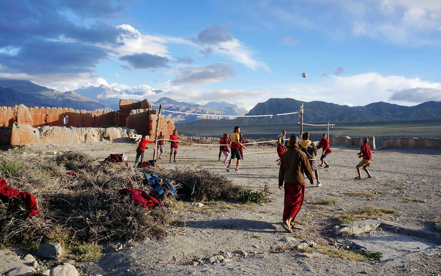
Forget the typical lush, green forests. Past Kagbeni, the landscape shifts to wide, dusty valleys and wind-carved cliffs that feel worlds away from Everest or Annapurna. Your ultimate destination is Lo Manthang—an ancient walled city where deep-rooted Tibetan Buddhist culture still thrives.
Because it sits in the rain shadow, this 18-day trek is one of the rare routes you can comfortably do during the monsoon, too. But there’s a catch: Upper Mustang has strict permit rules and requires a mandatory guide.
That’s where Radiant Treks steps in. We take care of the complex permits, local flights, and logistics, so you can focus on enjoying the hike.
Why Choose Our 18-Day Upper Mustang Trek Package?
- No Permit Headaches: You legally need a Restricted Area Permit (RAP) and an Annapurna Conservation Area Permit (ACAP) to get past the checkpoints during the Upper Mustang Trek. We handle all that paperwork for you before you even land in Nepal.
- Fully Covered Logistics: Your airport pickups, city hotels, domestic mountain flights, nightly teahouse beds, and daily trail logistics are included in the package. Just bring your gear and focus on the hike.
- A Safe, Natural Pace: We don’t rush the altitude. The itinerary builds in proper acclimatization time so you can explore local villages and viewpoints comfortably without feeling wiped out.
- Deep Cultural Ties: Walk through authentic Tibetan Buddhist villages and explore the ancient walled city of Lo Manthang with an experienced local guide who actually knows the traditions.
- Monsoon Escape: Tucked away in the Himalayan rain shadow, this region is one of Nepal’s few perfect trekking spots during the summer monsoon months.
- Short on Time? Try our 13-Day Upper Mustang Jeep Tour instead if you prefer a road trip over a long hike.
Upper Mustang Trek Cost
Our 18-day Upper Mustang Trek starts at USD 2,050 per person (based on group size).
Curious why this is pricier than standard Nepal routes? The increase is due to strict restricted area regulations and the additional logistics needed to explore this remote Himalayan kingdom. A major amount covers your mandatory Restricted Area Permit.
The remainder fully funds your trip: licensed guides, accommodation, transportation, domestic flights or road transfers, conservation permits, and full trekking logistics.
You don’t need to worry about sorting out permits, booking transport, or finding teahouses. Radiant Treks organizes the entire trip for you. All you have to do is show up and enjoy Upper Mustang.
Difficulty Level: A Moderate High-Altitude Cultural Trek
Is the Upper Mustang Trek difficult? We rate it as moderate. You won’t need technical gear or have to cross any dangerous mountain passes. But don’t underestimate it—you still need solid stamina to hike day after day in the thin mountain air.
Here is why we rate it as moderate:
- You will walk about 5 to 7 hours each day.
- Most of the trek sits well above 3,000 meters.
- The route peaks around 4,000 meters at Nyi La Pass.
- Dry air, steady wind, and dusty trails can quickly drain your energy.
- Long, exposed trail sections offer almost no shade during the day.
- Teahouse accommodations provide very basic, simple facilities.
- The remote location means medical care and transport options are strictly limited.
While altitude always matters, the gradual elevation gain makes this route far less extreme than Everest or Manaslu. If you are a reasonably fit hiker, then this trek is achievable.
How Our 18-Day Itinerary Helps You Succeed
We built this schedule for the Upper Mustang Trek to keep you comfortable so you actually enjoy the trek, rather than just survive it.
- Gradual Altitude Gain: We take the climbs slowly. Pacing the trek properly means your body actually gets the time it needs to adjust to the altitude.
- Balanced Walking Days: Expect to hike for five to seven hours a day. That leaves you plenty of daylight to check out the local monasteries and villages.
- Professional Local Support: Your guide manages the daily details during the trek and also monitors your health. They also share the real stories behind Mustang’s history and culture.
Upper Mustang Trek Preparation: Getting Ready for the Journey
A little prep goes a long way before heading into Upper Mustang.
- Permit Preparation: You cannot trek here independently. Radiant Treks secure all your restricted area permits in advance so you can hit the trail without delays.
- Gear Check: Before leaving Kathmandu or Pokhara, your guide will double-check your pack. Missing a warm down jacket or a sleeping bag? You can easily rent them locally.
- Preparing For The Climate: It rarely rains here, but temperatures swing wildly. You urgently require windproof jackets, warm layers, and solid sun protection for those fierce afternoon gusts.
Where To Sleep, What To Eat
- Kathmandu and Pokhara: You get a standard three-star hotel for your city nights. It is a comfortable spot to rest before heading out to the mountains and a great place to recover when you return.
- On the Trail: Along the route, you’ll stay in welcoming teahouses run by local families.
- Teahouse Facilities: They have simple but clean rooms. Expect a basic twin bed, and you need to share bathrooms most of the time. Evenings are spent hanging out in the main dining room, which is usually the only heated space in the lodge.
- Trekking Meals: Dal bhat is the main staple out here. You can also order fried noodles, soups, momo, and Tibetan bread. As you push deeper into Upper Mustang, the menus get shorter, but you will always get a hot, hearty meal to keep your energy up for the next day.
Regulations, Group Sizes and Mandatory Guides
- No Solo Trekking: Because the Upper Mustang is a restricted area, the rule prohibits trekking alone. You must be accompanied by a licensed guide whether you are trekking alone or in a group.
- Permits Sorted: We take care of all the paperwork. Our team pulls both your Restricted Area Permit and ACAP before the trek even begins, so everything is ready to go.
- Private Treks: Traveling as a couple, with family, or a group of friends? You can book a fully private trip and choose whatever start date works best for you.
- Group Departures: Flying solo? Hop into one of our scheduled group treks. It is a fun way to share the trail with other hikers and easily cover those strict permit rules.
- Expert Local Guides: Our guides do much more than just navigate. They know this region very well. They will walk you through ancient monasteries and share the real Tibetan culture that makes Mustang entirely unique.
Why Book Upper Mustang Trek With Radiant Treks
- Accommodation is sorted in advance → Hotels in Kathmandu and Pokhara, and teahouses during the trek, are booked before you arrive. You don’t have to search for rooms along the route.
- Meals are covered on the trail → All your meals—breakfast, lunch, and dinner—are fully covered every day you're out on the trail. It means you do not have to think about where to eat or what’s available each day.
- Guide who knows the route → A licensed, English-speaking guide stays with you throughout the trek. They set the pace, handle local interactions, and manage the day as it goes.
- Permits handled before the trek starts → The Upper Mustang Restricted Area permit and ACAP are arranged ahead of time through the agency. You won’t need to deal with the process yourself.
- Transport already planned → Travel from Kathmandu to Pokhara and onward to Kagbeni and back from Jomsom is included. You can upgrade to flights if needed.
- Basic trekking gear provided → Don't worry about packing the bulky stuff. Radiant Treks lends you a duffel bag, sleeping bag, and down jacket for the trip. As such, you don't have to buy or rent them yourself.
- The support team is taken care of → The Guide’s salary, insurance, food, and accommodation are covered. This arrangement keeps the same team with you, rather than changing staff along the way.
- Simple safety support on the trail → The guide carries a first aid kit and an oximeter. If something goes wrong, they coordinate rescue based on your insurance.
- Costs are clear from the start → Permits, meals, rooms, and the guide are already covered. You’ll only spend on personal things.
- Run by a local team → A Nepal-based team handles the trek and works in Mustang regularly, so things stay straightforward.
Detailed Upper Mustang Trek Itinerary
Kathmandu marks the starting point of your Upper Mustang journey. The altitude here is manageable, which makes it convenient to ease into the trip before heading higher.
A Radiant Treks representative will meet you at Tribhuvan International Airport and take you to your hotel. The drive isn’t long, though traffic can slow things down at times, and it gives you a first sense of how the city moves.
You won’t have a fixed plan for the rest of the day. Most people take it slow — resting, checking their gear, or sorting out permits. If you feel up to it, you can step out for a short walk. But there is no pressure. The idea is to settle in and get ready for what comes next.
This day is used to wrap up the practical side of the trip before leaving Kathmandu. There’s no fixed schedule — you move through things at a steady pace.
On this day, we arrange the required permits for the Upper Mustang Trek, check your gear, and help you buy anything you are missing in the city.
If this is your first meeting with your guide and team, the briefing — about the route, pace, and trail expectations — usually happens now.
The rest of the day stays flexible. Some prefer to rest, while others step out for a short walk or explore nearby areas at an effortless pace. You may join our half-day Kathmandu sightseeing tour as well.
Regardless of the approach, the emphasis is on being well-prepared rather than overly busy. Eventually, the goal is for a smooth start to the journey into Upper Mustang.
Elevation Loss: 578 m / 1,896 ft
Today, you head to Pokhara for the trek. And you do so via a road journey. The road winds out of the valley and then follows the Trishuli River for much of the way.
Along the route, you pass small towns, local shops, and stretches of farmland. Some sections are smooth, others a bit rough — that’s just how this road usually is.
The pace of the journey depends on traffic and road conditions, especially as you get out of the valley. There are a few natural stops along the way for tea, lunch, or just to stretch your legs.
By the time you reach Pokhara, the shift is noticeable. It’s quieter and more open, and the air feels lighter. From there, you are taken to your hotel near Phewa Lake. Most people don’t plan much after the drive. A short walk by the lakeside is enough, or you can just rest and settle in.
Note: If you want, a short flight (around 25-30 minutes) from Kathmandu to Pokhara can be arranged at an extra cost instead of a bus journey.
Elevation Gain: 1,982 m / 6,503 ft
Today, you reach one step closer to the Upper Mustang trek, and this endeavor begins with a drive to Kagbeni village. The journey begins after you finish your breakfast in Pokhara. After getting on your designated bus or jeep (if upgraded), the road goes northwards through Beni, Tatopani, Marpha, and Jomsom.
During the drive, you traverse from the green hills to a more open and dry valley of Kagbeni. This is a trip to an area in the Annapurna and Dhaulagiri ranges’ rain shadow.
The road condition past Beni is more rugged. Likewise, the valley opens up near Jomsom (2,740 m), and the wind here is stronger.
Kagbeni sits in the Kali Gandaki River Valley, where people find black fossil stones, known as ‘Shaligram.’ These are natural ammonite shells that Hindus revere as sacred.
Kagbeni is often referred to as the ‘gateway to Upper Mustang.’ This village features a cluster of old houses and narrow lanes. It is also an important checkpoint for Upper Mustang permits.
Your journey for the fourth day concludes here. But time permitting, you may explore the area, one of them being a visit to the Kag Chode Thupeten Samphel Ling Monastery.
Elevation Gain: 246 m / 807 ft
It is on the fifth day that the actual trek to Upper Mustang begins, as it was only a drive up until Kagbeni. Trekkers need to show their Upper Mustang permits before entering this restricted area — a key requirement for trekking in the Mustang region.
The path follows the Kali Gandaki River and gradually shifts into a drier landscape and wind-shaped cliffs and hills.
You pass Tangbe and continue to Chhusang, where caves are visible in the cliff faces. Some of these date back around 2,000 to 3,000 years and were used in different periods for burial, habitation, and later Buddhist practice.
Beyond Chhusang, you cross the river on a suspension bridge and climb steadily toward Chele. The uphill stretch is continuous, so the effort becomes more noticeable.
Upon arrival at Chele (Tsele), you notice the Tibetan-influenced character of the village in the form of mani walls, chortens, and prayer flags. You will do nothing more but spend the night at the teahouse, resting and adjusting to the altitude.
Elevation Gain: 750 m / 2,461 ft
From Chele, the trail begins with a steady climb toward Taklam La (3,624 m). From the pass, you get open views of Nilgiri and parts of the Annapurna range. After a short descent, the path climbs again to Dajori La — a pass at an elevation of 3,735 meters. This high pass was once part of trade routes linking Mustang with Tibet, used to move goods like salt.
The trail then continues to Samar, a stop where you can relax for some time. Near Samar, you pass the Rangchyung Chorten, located close to the cliffs. From here, the path follows ridges and narrow sections before reaching Syangboche. Wind gets stronger as you get closer.
Syangboche is a small settlement with a few teahouses. The evening is usually quiet here. And you have ample time to rest and have dinner before settling in for the night.
Elevation Loss: 280 m / 919 ft
Today, you ascend Yamada La Pass at 3,850 meters. In the ascent of about 50 meters, you get to see wind-shaped terrain, with copper-red canyon walls. Add to that the chance to see distinctive ‘four-colored chortens’ and prayer flags.
Following the ascent, the trail turns downhill. From the pass, the route continues toward Ghami, passing chortens and long mani walls carved with Tibetan prayers along the way.
These are common across the region and reflect the strong influence of Tibetan Buddhism.
The trail continues across open ground before reaching Ghami, a small settlement in a dry valley. The village is known for one of the longest mani walls in Mustang.
Ghami has a few teahouses, and the evening is usually quiet, with time to rest after the day’s walk.
Elevation Gain: 40 m / 131 ft
You do not directly trek to Charang, also known as Tsarang. Instead, after leaving Ghami, the route ascends to another pass — Nyi La. In the process, you walk past a long mani wall just outside the village. The path then opens into a wide, dry valley, with wind-shaped slopes and scattered fields.
The climb is gradual at first, leading up to the Nyi La Pass at 4,010 meters. This is a significant elevation gain of about 500 meters. From here, you can see across the valley before the trail drops again toward Charang.
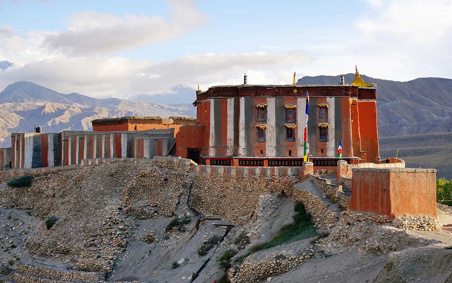
Charang sits slightly above the surrounding land, with white houses, a monastery, and old fort walls still visible. The monastery is worth a brief visit if open. Most people spend the evening quietly at the teahouse, resting after the day’s walk.
Elevation Gain: 280 m / 919 ft
From Charang, the path heads out over open ground toward Lo La, a pass around 3,950 meters high. The climb is steady and fairly exposed, and it can be windy in this section. You pass a few chortens and small settlements along the way.
At the top of the pass, Lo Manthang comes into view, set inside its walled boundary — one of the highlights of the Mustang trek in Nepal. From here, the trail drops slightly before reaching the town.
Lo Manthang has mud-brick houses and narrow lanes, with monasteries like Thubchen Monastery in the town. The old royal palace still stands at the center.
We keep this day relaxed upon our arrival at Lo Manthang. As such, the schedule allows time for leisurely walks and rest.
You use the entire day to discover Lo Manthang and its surroundings. Lo Manthang is the former capital of the Mustang Kingdom and is still enclosed within a walled settlement, which gives it a distinct layout compared to other villages in the region. You can begin with Jampa Monastery, one of the older monasteries in the area, known for its wall paintings and statues.
You can visit nearby monasteries or walk through the town to see its layout. The Royal Palace of Lo Manthang still stands at the center and reflects the region’s former royal structure. Other monasteries, such as Thubchen Monastery and Chode Monastery, are also located within or near the town.
You can take a short trip to the Chhoser Caves, where people carved multi-level caves into the cliffs. Some of these date back around 2,000-3,000 years and served different purposes over time, including shelter and later religious practice. The caves just sit north of Lo Manthang and are easy to reach on a side trip.
If your visit falls during the Tiji Festival (usually in spring), you may witness masked dances and local rituals. You end the day quietly in Lo Manthang, with time to settle in before the journey continues.
Elevation Loss: 20 m / 66 ft
You head out from Lo Manthang and follow a different route back. The goal is to reach Dhakmar. The trail moves across open, dry ground and follows narrow ridges at times, with a few small villages along the way.
On this route, you pass Ghar Gompa, an old monastery linked to Guru Rinpoche. Some trekkers stop here briefly before continuing.
As you get closer to Dhakmar, the landscape starts to change. The red cliffs above the village stand out clearly against the surrounding hills.
Dhakmar is a small place with a few teahouses. As evening comes in, the red cliffs slowly change color. And the Dhakmar village goes quiet for the night.
Elevation Loss: 250 m / 820 ft
From Dhakmar, you make your way toward Ghiling. The trail runs through dry, open ground with low ridges and exposed sections typical of Mustang.
On the way, you once again pass Ghar Gompa. The path then moves across rolling terrain and gradually leads back toward Ghiling. The village sits below open slopes and has a mix of traditional houses and a few teahouses.
By the time you reach Ghiling, the day has usually eased off, with enough time to settle in and rest.
Elevation Loss: 590 m / 1,936 ft
From Ghiling, you head back toward Chhusang. Like before, you need to cross dry, open ground with some rocky sections along the way.
On the way, you pass through Samar, where fields appear in small patches along the route. Parts of the trail cut through narrow sections before opening out again.
As you get closer to Chhusang, the red cliffs above the village come into view. By the time you reach Chhusang, the trail levels out. The sound of the Kali Gandaki River is constant here, and the pace of the day slows down again.
Elevation Loss: 260 m / 853 ft
From Chhusang, it is time to head back to Jomsom. For that, you follow the path along the Kali Gandaki River. The valley is wide here, with long, open stretches.
You go through Kagbeni again and continue along the riverbed. The walk is steady, though the wind often picks up later in the day.
Closer to Jomsom, more houses and small shops begin to appear along the trail.
Elevation Loss: 1,898 m / 6,227 ft
After breakfast in Jomsom, you drive down to Pokhara today. The road follows the Kali Gandaki, the same valley you have been walking through, so parts of it feel familiar. Early on, the track is rough and dusty in places, especially around Jomsom and beyond, and the ride can be slow.
You pass through Marpha and continue toward Tatopani. As you descend, you pass from the dry and dusty landscape to greener hills. After Beni, the road gets better, and the drive also feels easier.
By the time you reach Pokhara, the change is clear — it feels more comfortable and settled after the days in Mustang. You are taken to your hotel near Phewa Lake. Most people keep the evening simple — maybe a short walk outside, or just rest after the long drive.
Note: A shared jeep can be arranged for a more comfortable ride at an extra cost. But for those who hate drives, a short flight from Jomsom to Pokhara (about 20-25 minutes) is also available as an upgrade.
After the trek, you have a full day in Pokhara. A short boat ride on Phewa Lake is an easy way to start, especially if the weather is clear and the mountains come into view.
Around Lakeside, there are plenty of cafés and small shops, so most people spend time walking around or just sitting by the lake. If you want to go out a bit, places like the International Mountain Museum, Gupteshwor Cave, and Devi’s Falls are all within driving distance.
After the trek, you can relax as there is no fixed schedule for the day.
Elevation Gain: 578 m / 1,896 ft
After breakfast, you set off for your return to Kathmandu by road from Pokhara. It’s a long drive, and the time it takes depends on traffic and road conditions.
You’ll pass through familiar stretches along the river and small towns on the way. There are a few stops here and there, usually for tea or a quick break.
By the time you reach Kathmandu, it’s usually late afternoon or evening. You are taken to your hotel, and the rest of the day is open — most people just rest or step out for a short walk nearby.
Note: If you don’t want to spend the day on the road, you can take a short flight (around 25-30 minutes) from Pokhara to Kathmandu for an extra cost.
You leave Kathmandu today. For that, we drive you to Tribhuvan International Airport from your hotel, based on your flight time. From there, you either head home or continue with your journey.
By now, the experience of Upper Mustang stays with you — the landscapes, the villages, and the time on the trail linger long after the trip ends.
If your flight is late and you have some spare time, you may use it to buy last-minute souvenirs for your loved ones or just sip the authentic local coffee and enjoy the final hours in Kathmandu.
Trek Cost Details
Cost Includes
- Pickup on arrival at the airport and transfer to the hotel; airport drop-off for departure
- Drive from Kathmandu to Pokhara and back via public bus (flight upgrade option available)
- Drive from Pokhara to Kagbeni and from Jomsom to Pokhara by public vehicle (jeep and flight upgrade option available)
- Three nights’ stay at a 3-star hotel in Kathmandu (bed and breakfast basis)
- Two nights’ stay at a hotel in Pokhara (bed and breakfast basis)
- Thirteen nights’ accommodation (twin sharing) in teahouses/lodges during the trek
- Full-board meals (breakfast, lunch, and dinner) during the trek
- Seasonal fruits after dinner during trekking days
- Licensed, English-speaking trekking guide
- Food, accommodation, salary, and insurance for the guide
- Upper Mustang Restricted Area Permit and Annapurna Conservation Area Permit (ACAP)
- All necessary government taxes and paperwork
- Duffel bag, sleeping bag, and down jacket (to be returned after the trek)
- First aid kit and oximeter carried by the guide
- Emergency rescue coordination (rescue cost borne by client/insurance)
- Route map (printed) and company T-shirt
Cost Excludes
- Porter service (available at an extra cost of $280; can be shared between two trekkers)
- Optional private jeep upgrade from Pokhara to Kagbeni and from Jomsom to Pokhara (additional $500 for a group of 2-5 people)
- Optional flight upgrade from Jomsom to Pokhara at an additional $165 per person
- Optional flight upgrade between Kathmandu and Pokhara at $240 (round trip)
- Lunch and dinner in Kathmandu and Pokhara
- Personal expenses (snacks, drinks, alcoholic beverages, etc.)
- Charges for hot showers, Wi-Fi, and battery charging during the trek
- Personal trekking gear and clothing
- Travel insurance (should get one for high-altitude trekking)
- Tips for guide, porter, and driver
- Kathmandu sightseeing tour (optional on preparation/return days)
- Extra expenses due to delays (weather, flight cancellations, road conditions, or political situations)
Frequently Asked Questions
Trek Overview
Upper Mustang remained closed to foreign visitors until 1992. Tucked against the Tibetan border, it operated under its king for centuries. Because access is still strictly limited today, its ancient monasteries, walled villages, and authentic Tibetan culture remain perfectly preserved—earning it the "Forbidden Kingdom" title.
The Upper Mustang Trek, unlike the famous trekking routes like Everest Base Camp or Annapurna Base Camp, is more of a cultural trek. Instead of wandering through forests and alpine valleys, you will hike dry plateaus, colorful cliffs, ancient cave systems and centuries-old Tibetan villages. The restricted-area regulations also limit the number of visitors, and the trail is noticeably quieter. Add to that its rain shadow climate and unique history and Upper Mustang is one of a kind in Nepal.
If you want an experience beyond Nepal's crowded classic trails, the Upper Mustang Trek is absolutely worth the investment. It offers exclusive access to dramatic high-desert landscapes, ancient monasteries, and the historic walled city of Lo Manthang. Because it lies in a rain shadow, it’s also one of the few Nepal treks perfect for the summer monsoon season. While the restricted-area permits make it pricier than standard routes, the deep Tibetan cultural immersion and untouched, quiet trails make it a once-in-a-lifetime journey.
It features surreal desert landscapes together with authentic Tibetan culture. You will spend your days exploring the ancient walled city of Lo Manthang, checking out the mysterious sky caves at Chhoser, and visiting centuries-old Buddhist monasteries. Because it’s a restricted area, the trails stay totally crowd-free. It honestly feels less like a standard Nepal hike and more like stepping into a hidden Himalayan kingdom.
Route & Itinerary
Your trek officially starts at the Kagbeni checkpoint, the historic gateway to the restricted area. After exploring Lo Manthang, the trail finishes in Jomsom. From there, Radiant Treks will arrange your flight or drive back to Pokhara and then on to Kathmandu.
With Radiant Treks, the complete Upper Mustang journey takes 18 days. This covers all your travel between Kathmandu, Pokhara, Kagbeni, and Jomsom, giving your body plenty of time to safely acclimatize and letting you explore Lo Manthang without feeling rushed. If you are short on time, you can easily opt for a streamlined itinerary or jump on a scenic Upper Mustang jeep tour instead.
Once you head out from Kagbeni, you will hike through some amazingly preserved traditional villages like Chele, Syangboche, Ghami, and Tsarang on your way to Lo Manthang. You will usually return on a slightly different trail. Every settlement you pass is packed with authentic Tibetan culture—you will see centuries-old monasteries, classic mud-brick homes, and beautiful stone prayer walls right along the trail.
On a standard itinerary, the highest place you will actually sleep is Lo Manthang, which sits at 3,840 meters. You will definitely hike higher than that during the day when you are crossing mountain passes, but sleeping at a slightly lower elevation is the best way to help your body handle the altitude.
Definitely, it is possible. You will spend two nights in Lo Manthang, giving you one full day to explore it. The walled city makes a perfect base camp for exploring the surrounding area. From town, you can head out on short day hikes to discover traditional villages and ancient monasteries. The real standout, though, is a trip to the nearby Chhoser sky caves. Carved high into the cliff sides centuries ago, these ancient dwellings are some of Upper Mustang's most fascinating archaeological sites and give you a really cool look into the region's deep history.
Yes, you can but for that you need to choose your route accordingly. It means some itineraries stop at the temple on the way back, but others head straight to Jomsom. If you definitely want to see it, just let us know before booking so we can add it to your schedule.
Yes. Think of the 18-day Upper Mustang Trek itinerary as just a baseline. Radiant Treks will happily adjust the daily route and walking pace to fit your actual schedule. Want an extra day in Lo Manthang, a detour to Muktinath, or a jeep to skip some walking? We have got you covered. We will build exactly what you need.
Yes! If you don't want to walk for two weeks, the Upper Mustang Jeep Tour is a fantastic shortcut. You'll drive up to Lo Manthang, catching the same rugged landscapes and ancient Tibetan culture, just without the sore feet. Just brace yourself for a long, bumpy jeep ride.
It honestly depends on your travel style. Walking the trail lets you take things slow, sleep in remote villages, and actually meet the locals. Taking a jeep is way faster and definitely saves your knees. But if you have the time and decent fitness, hitting the trail beats driving every single time.
Cost, Booking & Package
Our Upper Mustang Trek starts at USD 2,050 per person for group departures. But your exact total will just depend on your group size, transport, and schedule. Keep in mind, it is pricier than most Nepal treks simply because it's a restricted area. It means special permits and a licensed guide are mandatory. This requirement eventually increases the trek cost. The final price also varies depending on your group size, chosen mode of transportation, and any itinerary customization you request.
Our Upper Mustang trekking package includes accommodation, meals on the trek, a licensed guide, necessary permits and transportation between Kathmandu, Pokhara, Kagbeni and Jomsom. Radiant Treks also provides a sleeping bag, down jacket and duffel bag for the trek.
Personal expenses are not included. They comprise travel insurance, tips for guides/porters, snacks & drinks, Wi-Fi, charging electronic devices, laundry and any additional costs caused by weather delays or changes to the itinerary.
It really does. You are sharing the costs of things like guides and transport with fewer people, so your price goes up in a smaller group. Bigger groups spread those costs around so you pay less per person for the same trek.
Yes, you can. If you are traveling solo, just join a scheduled group trip. It’s the easiest way to split costs and meet other trekkers. More importantly, going with a group automatically covers the strict restricted area permit rules for you.
Try to book a month or two early, especially if you are coming in spring or autumn. That gives us plenty of time to sort out your restricted permits, book teahouses, arrange transport, and confirm your dates. Since these are peak seasons in Nepal, things fill up fast, so booking ahead just guarantees your spot without any stress.
If your plans change, please send us a written message at your earliest convenience. The initial 20% deposit is non-refundable since it immediately goes toward locking in your permits and rooms. If you cancel within a week of departure, there’s a 30% fee. However, if it’s a real emergency, we can usually just reschedule your trip. For the full details, see Radiant Treks' policy.
Permits & Regulations
Yes, they are mandatory for foreign trekkers. You require two permits to trek in the Upper Mustang—the Upper Mustang Restricted Area Permit (RAP) and the Annapurna Conservation Area Permit (ACAP). Without these, you will not be allowed into the restricted area beyond Kagbeni.
Upper Mustang is close to Nepal’s border with Tibet and was off-limits to foreigners until 1992. Today the area is open to trekkers, but access is still controlled to help preserve its unique Tibetan culture, fragile environment and historical heritage. Hence, it has got the restricted area status, and special permits are still required to enter the region.
The Restricted Area Permit is USD 50 per person per day and the minimum permit period is 10 days. You will also need to get an Annapurna Conservation Area Permit (ACAP), which costs around NPR 3,000 for most foreigners. When you book, Radiant Treks includes these permit fees in the trekking package price.
No, you can't do it yourself. The government requires a registered agency to process Upper Mustang permits. Just send us your passport details, and Radiant Treks will handle all the paperwork long before you reach the Kagbeni checkpoint.
No, you can't. Government strictly bans independent trekking in Upper Mustang. All visitors must travel with a licensed guide and book through a registered agency. But remember that your guide is there for more than rules. He is there for your safety and permits, and he helps you connect with the local culture.
Difficulty & Fitness
The Upper Mustang Trek is generally considered a moderately difficult trek. There are no technical climbing sections, but you will be walking for 5 to 7 hours a day over several days. The combination of altitude, long walking days, dry weather, and exposed trails makes it more challenging than an ordinary hike, but manageable for most reasonably fit people. Most trails are wide and easy to follow, but you will also walk across gravel paths, loose stones, and uneven rocky sections that require careful footing.
Yeah. The Upper Mustang Trek is ideal for the beginner who is reasonably fit. No previous trekking experience is necessary, but you should be able to comfortably walk several hours a day on uneven trails. The most important requirements for the trek are a steady pace, proper preparation and following the advice of your guide.
For sure. People in their 60s and 70s are trekking all the time. Your actual age matters way less than your basic fitness level. Since there's no technical climbing, the main hurdle is just dealing with the altitude and being on your feet for a few hours a day. If you prep with regular walking at home and take it slow on the trail, you’ll be fine.
You don't need to be an athlete, but you need to have enough stamina to walk for 5-7 hours for almost two weeks. A regular walk, a light hike or even climbing stairs before you go can make the trek a lot more enjoyable, and your body will get used to the daily routine.
Typically, days of trekking are 5 to 7 hours of walking, depending on the destination for the day and trail conditions. On most days, you will cover approximately 10 to 15 kilometers, depending on the route, elevation gain, and the village where you spend the night. Some days are short, while others take a bit longer. The pace is generally relaxed, so you have plenty of time to enjoy the scenery, visit monasteries and take frequent breaks along the way.
No. The Upper Mustang Trek is a non-technical climb and requires no ropes or scrambling. There are some steady uphill climbs and rocky trails but they are well kept and don't require any mountaineering experience. The steady walking is what most people find more difficult than the terrain.
The best way to prepare is to keep moving in the weeks leading up to your trip. It can be regular walking, short walks, cycling or climbing the stairs. All these activities will help improve your endurance. You don't need to undertake an intense training plan but arriving with good basic fitness will make each trekking day feel much easier.
No. Most trekkers find Upper Mustang easier than both Everest Base Camp and Annapurna Base Camp. The highest altitude is lower, there are no extremely steep mountain passes, and the daily elevation gain is more gradual. The trek is more about culture than it is about endurance—although it still requires good fitness.
Altitude Sickness
The highest point reached on the normal Upper Mustang Trek is Nyi La Pass, some 4,000 meters (13,123 ft) above sea level. This is much lower than many popular Himalayan treks but you will still be spending a number of days above 3000 meters. So, it's important to pace yourself and stay well hydrated.
Altitude sickness is possible but usually less common than on treks that go above 5,000 meters. Climbing slowly allows your body to adjust naturally. But different people react differently to altitude, so walk slowly, drink lots of water and tell your guide if you feel unwell.
We plan an itinerary that includes gradual elevation gain, rather than rushing too quickly to higher villages. Your guide will also monitor your health during the trek. He will make sure you are walking at a comfortable pace. In addition, the guide will carry a first aid kit and oximeter to check your condition whenever necessary.
The most common sign is a severe headache. You might also feel dizzy or nauseous or completely lose your appetite. Feeling unusually wiped out, having trouble sleeping, or struggling to catch your breath even while resting are serious warning signs. If any of this happens to you, please let your guide know right away.
The easiest way to avoid it is simply taking it slow. Don't rush on the trail. You also need to drink way more water than you normally would—staying hydrated is huge. Skip the alcohol, eat well, and just listen to your body. If anything feels off, please let your guide know right away.
Best Time, Weather & Temperature
The best time to trek Upper Mustang is during spring (March to May) and autumn (September to November). These seasons have pleasant temperatures, stable weather and high visibility. If you want the best conditions for trekking, these are the months you should pick.
The climate of Upper Mustang varies by season but it is much drier than most trekking areas in Nepal. That is because it is in the rain shadow of the Himalayas. Here’s what you can look forward to each season.
Upper Mustang Trek Weather and Temperature
| Season | Weather & Temperature |
| Spring (March-May) | One of the best seasons. Most days are sunny and pleasant with temperatures of 10°C to 20°C. Night temperatures range from -5°C to 0°C. Expect dry trails with clear skies and occasional strong winds in the afternoon. |
| Summer/Monsoon (June-Aug) | Despite the monsoon elsewhere in Nepal, Upper Mustang remains relatively dry. Daytime temperatures range from 15°C to 25°C, with nights around 5°C to 10°C. This is one of the few Himalayan treks that's ideal during the summer months. |
| Autumn (Sept-Nov) | Great trekking season with stable weather and great visibility. Temperatures during the day are usually 10°C to 18°C. Nightime temperatures drop to around -5°C to 2°C. Autumn is a favorite among trekkers for its dry conditions and crisp mountain views. |
| Winter (Dec-Feb) | Winter is very cold at higher elevations. Daytime temperatures are typically between 0°C and 10°C. Nights can be anywhere between -10°C and -15°C. Some lodges might be closed. Warm clothing is a must when trekking at this time of year. |
Yes, it’s actually one of the best! Since Upper Mustang lies in the rain shadow of the Himalayas, it receives very little rain between June and August. While the rest of Nepal gets soaked, these trails stay remarkably dry. The Upper Mustang Trek is a perfect, trouble-free monsoon adventure with no muddy trails, continuous downpours or leeches to dodge.
Spring is mild with longer days and generally stable weather. Days are nice for walking, but mornings and evenings are still cool. It’s also one of the liveliest times to visit, with local villages becoming more active after winter and clear views across the surrounding landscapes.
Autumn is one of the best times for the Upper Mustang Trek. Weather is somewhat predictable, air is cleaner and visibility is better post-monsoon. In addition, this is the busiest trekking season in the region, making it livelier with fellow trekkers. Add to that clear skies, comfortable temperatures and dry trails.
Winter trekking is possible, but it’s best for those who don’t mind the cold. Throughout the day, temperatures drop significantly, and mornings and evenings can be particularly freezing. Some of the teahouses may even be closed for the season. So, if you are planning for the winter Upper Mustang trek, then you will need warmer clothes. Despite the challenges, the perk is the beautiful views and quieter experience.
Yes, especially during the afternoon. Winds are usually calmer during the morning, which is why most trekking days begin early. Strong winds are common on the open sections of the trail, particularly in spring and early summer. Starting your trekking day early helps you avoid the strongest winds, and carrying a windproof jacket and a buff makes the walk much more comfortable.
You get stunning mountain views in spring and autumn. However, autumn is especially known for the clearest skies after the monsoon has passed. Spring has beautiful scenery too, although some days can be hazy and visibility is limited.
Accommodation, Food & Facilities
You will stay in local teahouses along the trek and in comfortable three-star hotels in Kathmandu and Pokhara. Teahouses are simple but clean, usually twin-sharing rooms with basic beds, blankets and shared dining areas. They are not luxurious but they have everything you need after a day of trekking.
Yes, you usually can! Many teahouses have them, especially during the quieter months. Just know it really depends on the village and the size of the crowd. If you hike during the busy spring or fall peaks, be prepared to share a room if places fill up.
For the most part, you will be using shared bathrooms in Upper Mustang, especially higher up. A few lodges in the bigger villages might have attached baths, but definitely don't count on them. It's best to expect simple facilities and just enjoy the amazing local hospitality rather than looking for hotel-level comfort!
Yes, you can in most villages, though you will usually need to pay a small extra fee. Teahouses generally rely on gas or solar heaters. Since getting hot water can depend a lot on the weather and where you stay, it's a great idea to keep a small towel and your toiletries handy in your daypack! Electric blankets and room heaters are generally not available, so carrying a warm sleeping bag is the best way to stay comfortable on colder nights.
Teahouses serve up simple, freshly made meals perfect for fueling your hike. You will actually find a surprisingly big menu for being in such a remote area! Expect local favorites like dal bhat, momo, and Tibetan bread, alongside familiar options like fried rice, noodles, soups, potatoes, eggs, pasta, and pancakes. Fresh fruit and some vegetables become less common as you travel farther north because supplies have to be transported from lower villages.
For sure. Eating vegetarian is actually super easy up there, and many trekkers stick to a meat-free diet anyway. You will have no trouble finding things like dal bhat, veg noodles, fried rice, potatoes, soup, and eggs at pretty much every stop.
Definitely, but don't drink straight from the tap. The easiest thing to do is refill your bottle at the teahouses and use purification tablets, a filter, or a UV pen. You can buy bottled water in most villages, but bringing a reusable bottle is a much better choice so you don't leave plastic waste behind. Avoid drinking untreated stream or tap water, even if it looks clean, as it may contain bacteria that can cause stomach problems.
You can, but it’s highly discouraged. Dealing with plastic waste is a massive problem in these remote areas, so it’s much better to avoid buying single-use bottles altogether. Instead, just pack a reliable reusable bottle. You can easily refill it at the teahouses and use purification tablets to make it safe.
Usually, it's not a problem. Vegetarian food is everywhere, and some places can even manage basic vegan or gluten-free meals. Just keep in mind that your options will definitely shrink in the more remote villages. If you have strict allergies or dietary restrictions, let your trekking company know in advance so they can plan accordingly.
Transportation & Logistics
Almost every trip starts with getting from Kathmandu to Pokhara. From there, you will make your way up to Kagbeni, which is where the restricted area officially begins. Depending on your exact plans, you either drive, opt for a quick local flight, or do a mix of both. Once your trek is over, you will finish up in Jomsom and head back down to Pokhara and Kathmandu.
By default, the trip is all a drive, which is more affordable and completely weather-proof. However, flight upgrades are definitely available! Flying is quicker and gives you stunning Himalayan views. Radiant Treks can easily help you figure out what fits your budget and schedule best.
It really depends on what you are willing to trade off. Flights are fast and the views are amazing, but inclement weather grounds them constantly. The drive is long, dusty, and bumpy, but at least it's reliable. Ultimately, it depends on your budget and your patience!
Weather delays are fairly common on mountain flights. If your flight is cancelled, the usual alternative is to continue the journey by road. Our team will monitor the situation, explain your options, and help arrange the best available transport so your trip continues as smoothly as possible. Keeping one or two extra buffer days at the end of your Nepal trip is always a good idea, especially if you choose to fly.
Try to keep your main bag around 10 to 12 kg if a porter is carrying it. You'll just need a small daypack for yourself for trail essentials like water, snacks, and an extra layer. Packing light really helps make the whole trip easier for both you and your porter!
Yes, absolutely! Most hotels in Kathmandu and Pokhara will safely store anything you would rather not carry on the trail. This way, you take only the essentials to Mustang and pick up the rest when you return.
Guides, Porters & Groups
Yes. A licensed guide is required for everyone trekking in Upper Mustang. Because Upper Mustang is a restricted area, independent trekking is strictly off-limits. And having a guide is a huge help anyway! They handle permits, plan the route, chat with locals, and keep you safe on the trail.
Beyond just keeping you from getting lost, guides handle all the annoying permit paperwork and sort out your rooms at the teahouses. They translate for you, explain the local history, and monitor your health. If anything goes sideways on the trail, having a local there to sort it out is a total lifesaver.
You aren't required to hire one, but it's highly recommended. Lugging a heavy backpack day after day gets exhausting fast, even on a moderate trail like Upper Mustang. If a porter takes your main bag, you only have to worry about carrying a small daypack, leaving you with way more energy to actually enjoy the hike.
Porters carry a maximum of 20 kg, which is usually split between two trekkers. So, you will want to keep your bag right around 10 kg to keep things fair. Honestly, packing light just makes the whole experience so much easier!
Absolutely! Radiant Treks runs group trips throughout peak season. It’s a great option if you are traveling alone, want to save some money, or want to share the trail with fellow adventurers from around the world.
Yes, solo hikers join our scheduled trips all the time. It’s a fantastic way to meet other adventurers, split the costs of guides and transport, and just enjoy the trek without the headache of planning a private trip all by yourself.
You definitely can! Setting up a private trip is the perfect way to go if you just want to experience the trails with your partner, family, or your own group of friends. You get total control over your dates, daily pace, and route. Plus, you will enjoy a completely personalized adventure with focused, one-on-one support from your guide and the whole Radiant Treks crew from start to finish.
Ideally, you want between two and eight people. That range gives you a great mix of flexibility and company. Smaller groups let you set your pace, but having more people definitely saves everyone money.
Packing & Preparation
Keep your pack light, but be ready for shifting weather. Bring plenty of layers, a heavy down jacket, good trekking boots, a sleeping bag, and any personal medicines. Don't forget your sunglasses, sunscreen, and gloves. Upper Mustang gets extremely dry and windy, so a buff, lip balm, and moisturizer are lifesavers on the trail.
Yes, definitely. The teahouses do give you blankets, but they usually aren't thick enough for those freezing nights up high. You'll really want a proper sleeping bag so you can actually get a comfortable night's rest. If you don't own one, it's very easy to just rent one in Kathmandu before you head out.
Yeah, easily. Thamel in Kathmandu and Lakeside in Pokhara are packed with rental shops. You can pick up sleeping bags, down jackets, poles, and duffel bags for just a few dollars a day, which saves you from lugging heavy gear on your flight or spending a fortune buying stuff you might only use once.
You really need a solid pair of hiking boots with good ankle support and grip. Just make sure you actually break them in before you go, otherwise you will be dealing with blisters the whole time. Also, definitely throw some light sandals or comfy slip-ons in your bag—your feet will thank you when you're just hanging around the teahouses in the evenings.
Expect a lot of dust. The whole area is extremely dry, and the wind really kicks up in the afternoons, blowing dirt across the trails. A buff or a bandana is essential for covering your nose and mouth. The air will also dry you out fast, so make sure you pack your sunglasses, sunscreen, lip balm, and a decent moisturizer.
Yes, but it can be a bit tricky. Some teahouses will do laundry for you or let you wash a few things in the sink. As you get into the more remote villages, though, those options disappear, and the cold mountain air means wet clothes take forever to dry anyway. Your best bet is to just pack enough quick-dry clothes so you don't have to stress about it.
Yeah. Everyone remembers warm clothes but forgets things like sunscreen, lip balm, moisturizer, a reusable bottle, purification tablets, a power bank, and a buff. Because Upper Mustang is so dry and windy, these little items actually end up being total lifesavers.
Health & Safety
Absolutely. It's actually one of the safer routes in Nepal. The trails are really clear and easy to follow, and there's zero technical climbing involved. As long as you have a licensed guide, keep a steady pace, and follow their advice, you shouldn't have any issues.
It's possible since you will be above 3,000 meters for days, but it's much lower risk than those 5,000-meter treks like the Manaslu Circuit Trek. Just take it slow, drink lots of water, and let your body adjust. Doing that usually keeps any symptoms away.
A few villages have basic clinics, but medical help is really limited up there. For anything serious, you will have to head back down to Jomsom or Pokhara. Definitely pack your own prescription medicines and a first-aid kit just in case.
Absolutely. Make sure you get a policy that specifically covers high-altitude trekking and helicopter rescues. It will also save you from a massive headache if you ever face surprise medical bills, bad weather delays, or have to cut your trip short.
Yes. If you get seriously hurt or hit with bad altitude sickness, a helicopter is the only fast way out. Those flights cost thousands of dollars, and you definitely don't want to pay for them yourself. Just make sure your policy explicitly covers both rescues and trekking up to at least 4,000 meters.
Your guide takes charge immediately. They will figure out exactly what to do—whether that means heading down to a lower elevation, getting you to a local clinic, or calling your insurance for a helicopter rescue.
Culture, Lo Manthang & Local Life
It’s best known as the ancient, walled capital of the former Kingdom of Lo. It’s packed with centuries-old Tibetan Buddhist monasteries, the historic Royal Palace, and remarkably preserved Tibetan culture. People also flock there to experience the vibrant annual Tiji Festival inside its distinctive mud-brick walls.
Absolutely. Upper Mustang is actually renowned for its unique culture and stunning landscapes. In Lo Manthang, you can explore 15th-century sites like Jampa Lhakhang and Thubchen Gompa. You'll also pass Ghar Gompa, an 8th-century monastery linked to Guru Rinpoche, and can even visit incredible cave monasteries like Luri Gompa that are built directly into the cliffs.
Just past Lo Manthang, you'll find hundreds of ancient rooms dug directly into the rock walls. Locals hand-carved these stacked caves centuries ago to use as homes, tombs, and hideouts. You can still climb up the ladders and walk right through them today.
Tiji is a three-day festival held in Lo Manthang every spring. Monks gather in the town square to perform incredible, vibrant masked dances. It's a centuries-old ritual meant to chase away bad spirits and celebrate good beating evil. If you can time your trek for it, it's totally worth it.
Absolutely! It's actually the most popular time to go. The only catch is that the trail gets super crowded. Since everyone wants to see the festival, you have to book your trip months in advance to guarantee your permits and teahouse beds before they completely sell out.
It’s pretty much the closest you can get to old-school Tibet. Because the region was isolated for so long, the culture is incredibly well-preserved. Daily life completely revolves around Tibetan Buddhism. You’ll hear Tibetan dialects, see locals in traditional dress, and pass ancient monasteries and colorful prayer flags everywhere you look.
It’s mostly about common sense. Always walk to the left (clockwise) around religious shrines and prayer wheels. Dress modestly—so definitely skip the short shorts. If you want to take someone's photo, just ask first. And remember to slip your shoes off before stepping inside any homes or monasteries.
Photography, Internet & Money
Service is often unreliable. You’ll get decent service with a local SIM in bigger towns like Lo Manthang. But once you are out on the trail, you will be completely off the grid for days. Enjoy the excuse to unplug!
You can find Wi-Fi at most teahouses along the way, but you'll usually have to pay a little extra for it. Just a heads up, the signal is rarely strong enough for much more than sending a quick text. Honestly, it's the perfect excuse to just put your phone away and enjoy the mountains.
You can charge your gear at almost every teahouse, but it usually isn't free. Since many places rely on solar power, they charge a small fee per device or per hour. Definitely pack a solid power bank so you don't have to wait in line for the few available wall outlets every evening.
You shouldn't rely on them. While you might spot an ATM in Jomsom or Lo Manthang, they are frequently out of cash, broken, or simply reject international cards. The entire trek is strictly cash-based. Make sure to withdraw all the Nepali rupees you will need back in Kathmandu or Pokhara.
Yes, absolutely! The entire Upper Mustang trek is strictly cash-based. Once you leave Kathmandu or Pokhara, reliable ATMs disappear entirely, and teahouses don't accept cards. You'll need to withdraw enough Nepali rupees to cover all your meals, charging, showers, and tips before you start walking.
That might not be possible. Once you start the trek, your credit cards are basically just useless plastic. Teahouses, small shops, and monasteries only accept cash in Nepali rupees. Save the cards for your time back in Kathmandu or Pokhara, and bring plenty of cash for the trail.
You will need to hire a local trekking agency to handle this paperwork. First, you must declare it at customs upon arrival. Then, you have to register with the Civil Aviation Authority, get clearance from the Ministry of Home Affairs, and secure an ACAP permit. It’s incredibly expensive and requires weeks of preparations.
Mostly no. While you can snap as many pictures as you want of the stunning courtyards outside, photography inside the actual prayer rooms is almost always strictly off-limits. This protects the ancient murals and respects the sacred space. Always ask a monk before pulling out your camera just to be safe.
Responsible Trekking
Basically, just leave the place exactly as you found it. Keep your trash in your pack until you are back in town, and use a refillable water bottle instead of buying plastic. Stay on the actual paths, and just be polite to the locals—dress modestly and ask before snapping pictures.
Definitely. There's zero recycling up there, so every plastic bottle you buy just gets dumped or burned. Bring a good reusable bottle and use water purification tablets or a filter instead. It’s way cheaper for you and actually keeps the mountains clean.
The easiest way is just to keep your money local. Stay in family-run teahouses, buy snacks from village shops, and hire local guides or porters. When you are buying souvenirs, try to skip the aggressive haggling. Paying a couple of extra dollars won't ruin your trip, but it makes a huge difference for them.
Upper Mustang Trek Packing List
Packing for the Upper Mustang Trek is a little different from packing for most trekking routes in Nepal. Unlike Everest Base Camp or Annapurna Base Camp, Upper Mustang sits in Nepal’s rain shadow, which means the region stays dry even during the monsoon. Rain isn’t usually the biggest concern here. Instead, you will deal with strong sunshine, dry air, dusty trails, chilly mornings, and cold evenings.
The good news is that you don’t need to overpack. Most trekkers wear the same hiking clothes for several days, changing only their base layers and socks when needed. Since you’ll spend around two weeks on the trail, packing smart is far more important than packing heavy.
If you are trekking with Radiant Treks, your larger bag can be carried by a porter (if you have hired one), while you only carry a small daypack with your daily essentials. Before leaving Kathmandu or Pokhara, your guide can also help you check your gear and make sure you haven’t forgotten anything important.
Below is a practical packing list that covers everything you’ll actually need for the Upper Mustang Trek.
Clothing
The weather in Upper Mustang changes throughout the day. Mornings can be close to freezing, afternoons often become pleasantly warm, and the wind can make temperatures feel much colder than they actually are. The best approach is to dress in layers so you can easily add or remove clothing as conditions change.
Base Layers
These are the clothes you’ll wear while trekking each day.
- 3 quick-dry trekking T-shirts – Lightweight synthetic shirts dry quickly and stay comfortable during long walks.
- 1-2 long-sleeve trek shirts – They are best when the temperatures are cold and also protect your arms from the mountain sun.
- 1 thermal top and 1 thermal bottom – Useful during cold nights and early morning starts.
Warm Layers
You’ll appreciate these once the sun goes down.
- 1 fleece jacket or mid-layer – Provides warmth without adding too much weight.
- 1 down jacket – Essential for higher villages, cold mornings, and evenings.
Outer Layer
Wind is often more noticeable than rain in Upper Mustang.
- 1 windproof and waterproof jacket – Helps block cold winds while also protecting you if the weather changes unexpectedly.
Trekking Pants
- 2 pairs of pants – Go for lightweight, quick-drying pants that are easy to hike in.
- 1 pair of lightweight shorts (optional) – Handy for warm afternoons in the spring or fall.
Underwear and Socks
- 4–5 pairs of underwear
- 3–4 pairs of trekking socks: Invest in good ones. Quality socks are your best defense against painful blisters on the trail.
Footwear
Your feet do most of the work, so comfortable footwear is one of your most important investments.
Trekking Boots
- One pair of sturdy trekking boots or hiking shoes
Choose boots with good grip and ankle support. Most importantly, wear boots you’ve already broken in. New boots are one of the most common causes of blisters.
Camp Shoes
- Light sandals or comfortable shoes
These give your feet a chance to breathe once you’ve finished walking for the day.
Protection from the Sun, Wind, and Cold
Upper Mustang is open and exposed, with very little natural shade. A few small accessories can make a huge difference.
Headwear
- Sun hat or cap
- Warm beanie or wool hat
You’ll often use both on the same day.
Sunglasses
- UV-protection sunglasses
The high-altitude sun can be surprisingly intense, especially on bright afternoons.
Gloves
- Lightweight gloves
Perfect for chilly mornings and windy sections of the trail.
Buff or Neck Gaiter
A buff is one of the most useful items you can carry. It protects your face from dust, wind, and cold while also providing extra warmth around your neck.
Trekking Gear
Besides clothing, you’ll need a few basic pieces of trekking equipment.
Backpack
- 20–30 litre daypack
Carry your water, camera, snacks, jacket, and personal items while trekking.
Duffel Bag
If you’re using a porter, pack the rest of your belongings in a duffel bag.
Trekking Poles
Definitely bring these. They save your knees on long descents and keep you steady on uneven, rocky trails.
Sleeping Bag
Teahouses provide blankets, but they are rarely sufficient at higher elevations. Bring:
- A solid sleeping bag
- A sleeping bag liner (optional)
Rain Cover or Dry Bags
A pack cover or waterproof dry bags will save your clothes and electronics from thick trail dust and sudden rain.
Daypack Essentials
Only carry the items you’ll need while walking.
Water
- 1–2 reusable water bottles
Staying hydrated is especially important because the air in Upper Mustang is extremely dry.
Water Purification
- Water purification tablets or
- Portable water filter
These allow you to refill your bottles safely instead of buying plastic bottles every day.
Snacks
Throw a few lightweight snacks in your bag for a quick energy boost between meals.
- Energy bars
- Nuts
- Dried fruit
- Chocolate
Health and First Aid
Medical clinics are hard to find once you get deep into Upper Mustang, so you definitely need to pack a small personal medical kit. Make sure to bring:
- Your personal medications
- A basic first aid kit
- Blister plasters or tape (a real lifesaver on the trail)
- Pain relievers
- ORS or electrolyte packets
- Water purification tablets
- Antidiarrheal medicine
- Bandages
- Antiseptic cream
Also, talk to your doctor about bringing Diamox (Acetazolamide) to help fend off altitude sickness.
Toiletries and Personal Care Items
Keep your toiletries simple and travel-sized.
Pack:
- Toothbrush
- Toothpaste
- Small soap or body wash
- Hand sanitizer
- Wet wipes
- Facial tissues
- Small quick-dry towel
- Toilet paper
- Nail clipper
- Small waste bag
- Earplugs
Shared teahouses can sometimes be noisy, so earplugs often help you sleep better.
Dry Climate Essentials
This is where Upper Mustang differs from many other trekking destinations in Nepal. The air is dry, dusty and often windy, which can make your skin and lips feel uncomfortable if you are not prepared
Bring:
- Lip balm
- Moisturizer or skin cream
- High-SPF sunscreen (SPF 50+)
- Nasal saline spray to reduce dryness inside your nose
- Buff or face covering for dusty sections of the trail
Many trekkers say these small items become some of the most-used things in their backpack.
Electronics
Electricity is available in most villages, but charging usually comes with an additional fee.
Carry only what you’ll actually use.
Pack:
- Mobile phone
- Camera (optional)
- Power bank
- Charging cables
- Universal travel adapter
- Headlamp or small flashlight
- Spare batteries or extra camera battery
- Extra memory card (if carrying a camera)
- A headlamp is especially useful for early morning departures or walking around the lodge after dark.
Documents And Cash
Before you leave Kathmandu, make sure you have all your important documents safely tucked away in your bag. Bring your
Travel Documentation
- A couple of passport copies
- Travel Insurance Documents
- Emergency contact numbers of
- Printout of itinerary – optional but useful
Money
Have enough Nepali Rupees for your daily trail expenses. Even though your package covers your main meals and teahouse stays, you will definitely want extra cash on hand for the following:
- Hot showers
- Charging your phone or camera
- Wi-Fi access
- Extra drinks and trail snacks
- Souvenirs
- Tips for your guide and porter
You won’t find any reliable ATMs out in the mountains. Make sure you take out all the cash you need in Pokhara or Jomsom before you start your trek.
Optional but Useful Items
These aren’t essential, but many trekkers are glad they packed them.
- Small notebook and pen
- Playing cards or a book
- Lightweight reusable shopping bag
- Small sewing kit
- Safety pins
- Plastic bag for dirty clothes
- Compact binoculars for spotting wildlife and distant monasteries
Final Packing Tips
The biggest mistake many first-time trekkers make is bringing too much. For the Upper Mustang Trek, aim to keep your total luggage around 10 to 12 kilograms, excluding water. You will be much more comfortable walking with a lighter pack, and you will quickly find that you don’t need a fresh outfit every day.
Focus on a simple layering system rather than bulky clothing. A good down jacket, comfortable trekking boots, and a windproof outer shell will serve you far better than packing extra clothes you’ll rarely wear.
Don’t underestimate the effects of the region’s dry climate. Sunscreen, lip balm, moisturizer, sunglasses, and a buff are just as important as your warm clothing. These small items can make a surprisingly big difference to your comfort throughout the trek.
Finally, if you are missing larger items like a sleeping bag, down jacket, or trekking poles, there’s no need to buy everything before your trip. You can easily rent quality equipment right in Kathmandu. Your Radiant Treks guide will double-check your pack to ensure you’re completely ready before heading to Upper Mustang.
Real Stories from our TripAdvisor Page
Curious about what travelers say about Radiant Treks? Discover genuine experiences on our Reviews Page.
Upper Mustang Trek Route Map


