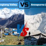
Overview
If you are dreaming of the Langtang Valley Trek, a solid Langtang trek map is your best friend for a seamless adventure. A good trek map helps you picture the 75-80 km journey that takes you through Nepal’s stunning Langtang National Park. In the trek that can be covered in 8 days, you will soak in jaw-dropping Himalayan views, swap between lush valleys and rugged peaks, and dive into the warm Tamang culture. And a right Langtang Valley trek map shows those routes, stop points and elevations climbing from 1,400m in Kathmandu to over 5,000m on side hikes.
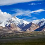
An apt map lays out daily paths, cozy teahouses and even altitude charts for your 8-day Langtang Valley trek from Syabrubesi to Kyanjin Gompa and back. Pair an itinerary or route map from outfits like Radiant Treks with a topography map and you get the full information of the route. Peaks like Langtang Lirung (7,227m) and terrain shifts from forests to glaciers are well-represented in such maps. Similarly, digital and guidebook versions add layers for real-time navigation and cultural insights.
Combining these Langtang trek maps empowers trekkers. Spot potential challenges like steep ascents or river crossings early, especially with updated maps that include recent information on improved roads and post-2015 earthquake reconstructions.

At Radiant Treks, we emphasize how a reliable Langtang Valley trek map turns planning into excitement, ensuring safety in this remote gem. This guide gets deep into types, decoding, routes and tips to master your map.
Highlights
- A reliable trek map keeps you safe as it marks safe paths and emergency spots
- Itinerary maps are easy and simple to read, while topography maps contain detailed information
- Maps can be used to plan a trek route from Kathmandu to Kyanjin Gompa and beyond
- Mastering the ups and downs of elevation with map charts helps you adjust to the climb up to 5,000m
- Spot landmarks like Langtang Lirung and sacred sites with the map
- Understand the terrain shifts using topography maps to take every step along the trail confidently
Types of Maps to Navigate the Langtang Trek
Picking the right Langtang Valley trek map can be an important step in making your trip successful. There are several types of such maps available and each serves a unique purpose. Understanding them helps you pick what fits your needs.
Let’s take a look at the options, drawing from reliable sources like trekking agency maps and most recently updated online sources:
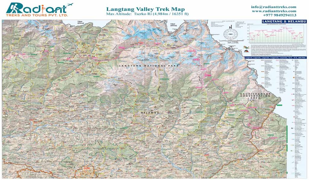
Printed Topography Maps
They help you understand the geography of an area. Topography maps use contour lines to showcase elevation gradients, valleys and ridgelines. As such, they offer a detailed overview of the terrain you are trekking to. Similar is the case of the Langtang trek map.
This map highlights gorges, alpine meadows, along with the surrounding peaks of the Langtang Valley. It also marks significant geographical features of the region, including the Langtang Khola. It helps you locate the areas that are prone to landslides. Therefore, this makes the map an invaluable resource for trekkers navigating challenging off-trail sections.
Typically scaled at 1:125,000, these maps enable precise distance calculations, such as the approximately 10-kilometer stretch from Syabrubesi to Lama Hotel. They are characterized by steep forested inclines. And you get them in printed form, meaning it is possible to carry in a pocket, accessible in areas without internet access and comes equally handy for group as well as individual trekkers.
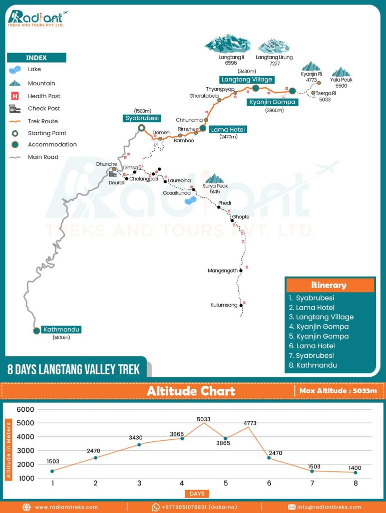
Itinerary Maps
They are designed for operational planning of the trek and are particularly useful for individuals who are new to trekking. The Lantang trek map from Radiant Treks is one example of this category. It presents an 8-day route with a clearly marked orange path. While a dotted line indicates side excursions, there are also symbolic representations of facilities such as teahouses and health posts.
The map commences at Kathmandu (1,400m), progresses through intermediate points like Ghoratabela and concludes and Kyanjin Gompa (3,865m). The itinerary map is further accompanied by an altitude chart that tracks elevations up to 5,033m. Your trekking agencies often provide such maps. They have downloadable versions along with cost estimates and itineraries.
To sum it up, such maps are ideal for beginners and offer a clear idea of logistics like teahouse locations and health posts, which are vital in a remote region.
Digital Maps
Digital trek maps allow the use of technology for enhanced navigation of the trekking trail. Applications such as Gaia GPS and AllTrails show the digital versions of what the printed maps show. These tools also let you add topography layers, giving you live elevation updates. It is handy with recent improvements like the new paved road to Syabrubesi.
But you need to keep your device fully charged, so it works best as a backup plan. Add to that the reduced chance of getting lost in fog, as these apps provide GPS tracking.
The Best Approach?
If you are confused about which version of the map is the best, then consider combining topography, digital and itinerary maps. You can use a topography map for awareness of Langtang’s terrain. As it shows contour lines, ridges and valleys, the map helps you understand where the trail becomes steep or levels out.
Likewise, use an itinerary map for scheduling your journey. That is because it highlights villages, teahouses, health posts and checkpoints along the way.
If you opt for this hybrid method, it helps with permit planning as well, especially for obtaining and presenting the Langtang National Park entry permit at the right points.
In practice, the best way is to print a physical itinerary map for daily reference while also using a digital topography map, such as Gaia GPS or AllTrails, for flexibility and real-time navigation. All in all, you thrive by combining both resources as it makes your trek safer, smoother and more rewarding.
Why Maps for Trekking in Langtang

A Langtang trek map is more than a piece of paper or a digital file. It is a valuable asset when you are in one of Nepal’s most captivating yet challenging regions. Without a map, you would be navigating blind through an unpredictable and demanding area. But with a map, you gain control over your journey.
Therefore, these maps are non-negotiable and the following points, backed by real trekking insights, add value to their roles:
Safety
The Langtang Valley, which is a part of Nepal’s first Himalayan national park, was established in 1976. It spans diverse ecosystems from subtropical forests to high-altitude deserts. Meanwhile, after the earthquake of 2015, when an avalanche wiped out Langtang Village, trails were rerouted for stability. In this context, a good Langtang trek map marks these changes. It also highlights safe paths and emergency exits along the route.
For instance, health posts and checkpoints are indicated on the itinerary map of Radiant Treks. They are crucial for altitude-related issues. Meanwhile, topography maps reveal hazards like cliffs or river fords. Being aware of these factions cautions you so that you can avoid mishaps during monsoon swells.
Easy Navigation
Navigation of the trekking trail becomes effortless if you have a detailed Lantang Valley trek map. The route twists through rhododendron blooms in the spring. It traverses through snowy passes in winter. But if you choose to hike on this path without guidance, then there is a chance that you may get lost on your way.
Hence, itinerary maps come in handy in these cases, as they provide linear directions, such as the 6-7 hour hike from Syabrubesi to Lama Hotel. Meanwhile, topography maps offer special context. For instance, they show how the valley narrows down toward the Tibetan border. This is especially useful when the visibility is low. In such conditions, the digital maps with integrated GPS shine, easing your trek experience.
Planning Aide
The Langtang trek maps excel in your trek’s planning phase as well. That is because they help calculate distances and elevation. The altitude charts in the map plot elevation gains like the 970m climb on Day 2 of the Lantang Valley trek. This aids acclimatization strategies. Depending on your day of the hike, you can choose to rest at Mundu or Lantang Village.
The maps benefit you by allowing you cultural planning as well. The maps trace routes past sacred sites, including the Kyanjin Gompa monastery. This religious site was rebuilt with community efforts after the earthquake of 2015. Historically, the valley was a trade hub for salt and wool. And the modern topography maps contextualize this aspect, enhancing your appreciation of the region.
Building Confidence
Carrying a reliable Langtang Valley trek map builds confidence in trekkers. Knowing you can locate water sources or a teahouse reduces anxiety when hiking in remote areas. As a result, you are confident to move ahead in the areas with limited cellular services, even if you are unable to communicate with anyone.
Many maps also incorporate tips, like staying on marked trails to protect endangered species, including red pandas and Himalayan black bears. This guides you to stay on your path without adversely affecting the environment.
Decoding the Maps

Mastering a Langtang Valley trek map starts with understanding its diverse components. Itinerary and topography maps are the most common ones. And it is straightforward to decode them once you know the basics. Refer to the following examples to make it clear.
Reading Itinerary Map
Route Line: A bold orange line traces the journey from Kathmandu through Syabrubesi to peaks like Tsergo Ri.
Symbols and Icons: If you see a blue circle with a white center, it is the starting point of your trek. Symbols of tents are used to denote base camps. ‘H’ in red means there is a health post nearby. A blue circle bordered by an orange line is to point out available accommodation.
Altitude Chart: It is a line graph across days and shows ascents and descents. This is helpful to spot acclimatization days.
Legends and Trail Types: Legends explain line styles. If you see a solid gray line, then it is for main roads. Likewise, dotted lines are used to symbolize side paths like Gosainkunda.
Labels and Extensions: The Langtang trek map, especially the itinerary map of Radiant Treks, clearly labels villages and landmarks along with their elevations. This also includes optional add-ons to Gosainkunda. At the side of the map, there is a list of main stop points in the Lantang Valley Trek itinerary.
Reading a Topographic Map
Contour Lines: The curved lines on a topography map of the Lantang trek suggest changes in elevation. If you see the bands representing 20-100m elevation intervals clustering tightly, then it indicates steep slopes. You can find them near Kyanjin Gompa. Likewise, if there is wider spacing among these lines, then they indicate gentler terrain.
To read the contour lines, you should understand a few things. For instance, if you are looking at the section between Lama Hotel (2,470 m) and Langtang Village (3,430 m), that’s a height difference of 960 m. On a map with an 80 m contour interval, you’d cross roughly 12 contour lines.
Color Codes: Different colors denote diverse features, especially landscapes. The color blue represents rivers, such as the Langtang Khola. Green is for forests and white is for glaciers.
Landmarks and peaks: In the topography map, peaks like Yala (5,500 m) are showcased with the use of a black triangle symbol. This map also highlights Gosainkunda Lakes along with suspension bridges across the rivers using different symbols.
Scale and Distance Measurement: Scales allow trekkers to measure distance. In this map with a scale of 1:125,000, 1 cm equals 1.25 km on the ground. You can refer to this measurement to estimate the daily walking range.
Orientation and Grid References: Maps align with north and they often use a compass for bearings. Likewise, grid references pinpoint locations.
Combine with itinerary maps: overlay routes to see why a flat-looking day on paper feels grueling due to contours.
Updated Safety Notes: Recent maps include trails adjusted after the earthquake of 2015 and newly constructed bridges. They are useful for more reliable navigation.
Trek Route Breakdown with Map Insights
The Langtang Valley Trek map lays out a rewarding round-trip trail, which can be completed in around 8 days. Using an itinerary map for steps and a topography map for context, you are able to break down your journey with proper planning.
Read the following part to understand the major stop points as you break down the route of the Lantang trek map.
Kathmandu to Syabrubesi
Drive Duration: 7-8 hours
Elevation: 1,503m
The journey begins with a scenic drive, which is marked on the itinerary map by a solid gray line representing the highway. This route passes a key checkpoint where permits are required. Meanwhile, the topography map reveals the initial hilly terrain as you enter the national park. With smoother roads in recent days, it can reduce your travel time slightly. Also, keep an eye out for the charming village of Betrawati along the way. It is a good spot to stretch your legs before arriving at Syabrubesi.
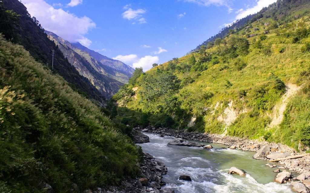
Syabrubesi to Lama Hotel
Trek Duration and Distance: 6-7 hours, 12km
Elevation: 2,470m
The orange line on itinerary maps follows the Bhote Koshi River as you start the trek from Syabrubesi. Along the route, the map guides you to the path, which requires you to cross bridges at Domen and Bamboo. One of the stops includes hot springs if detoured. Similarly topography map highlights forested slopes. Remember that the tight contours mean steady climbs through pines, with rivers as blue lines posing flood risks in rain.
Lama Hotel to Langtang Village
Trek Duration and Distance: 5-6 hours, 10km
Maximum Elevation: 3,430m
Itinerary details in the Langtang trek map waypoints like Rimche and Ghodatabela (it is the army checkpoint). The map shows the path entering the rhododendron zones. You can find them blooming from March to May.
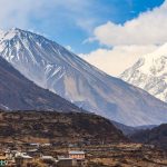
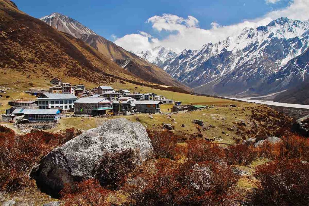
Likewise, the topography maps show the Lantang valley narrowing and contours ease into meadows. The Langtang Village, rebuilt after the 2015 earthquake, appears as a cluster of icons on the map. Following the map, trekkers can explore cheese factories here.
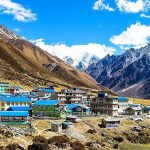
Langtang Village to Kyanjin Gompa
Trek Duration and Distance: 3-4 hours, 7km
Maximum Elevation: 3,865m
This section of the journey requires a short ascent past Mundu. The Langtang Valley trek map that focuses on itinerary details showcases the opening views of nearby mountains. The topography map reveals plateau-like terrain and also highlights the flanks of towering Langtang Lirung. Along the route, Kyanjin Gompa appears as a landmark, helping you understand where to acclimatize. You might even try local yak butter tea to stay warm during the trek, as per the map guidance.
Exploration from Kyanjin Gompa
Trek Duration: 5-7 hours
Maximum Elevation: 5,033m
The itinerary map marks side hikes that you can begin from Kyanjin Gompa. One of such explorations is a trek to Tsergo Ri (5,033m). This route with dotted lines suggests a hike to a rugged landscape. The steep gradients in the topography map warn of rocky terrain in this section. But the reward is a breathtaking 360-degree panorama of the surrounding peaks and valleys, as indicated by the map.
If you follow the map closely, you realize that a gentler option is the hike to Kyanjin Ri (4,773m). This hike offers stunning views but with less effort. Some detailed maps extend the exploration to nearby glacial areas as well. You can opt for this to add to the adventure.
Return to Syabrubesi to Kathmandu
The return journey follows the retraced path of the itinerary map, which suggests that you need to opt for the downhill trek. And it feels lighter on the legs as compared to the uphill journey. The topography map suggests an alternative route via Thulo Syabru for a bit of variety if time allows. Improved signage, which is based on recent trail maintenance, helps keep you on track and reduces the chance of getting lost along the trekking trail.
Tips for Using Maps
Getting the most out of your Langtang Valley trek map takes a bit of preparation and some smart habits while you’re out on the trail. Here is a detailed suggestion on how to navigate the Langtang trek trail like a pro.
Preparation
- Pack a simple itinerary map for the basics and a topography one for a deeper look at the terrain.
- If you notice slight differences in elevation readings between maps, you can average them out.
- Print out waterproof copies so that they are not damaged by rain. You can laminate them for extra protection. Also, load the printed maps onto apps ahead of your trek by marking waypoints.
On-Trail
- Lean on your itinerary map to set daily targets, like making it to Ghodatabela by lunchtime for a good break.
- When you hit a fork in the trail, peek at the topography map’s contours to pick the smoothest path – those lines can save you a lot of effort.
- Keep digital maps handy for the latest updates. But do not forget to switch to airplane mode as it saves battery life on your cellphone.
- If you’re trekking with others, pass around annotated maps so everyone’s in the loop and can chip in with ideas.
Strategic
- Use contour lines to locate the best camping spots. Likewise, the flat areas on the topography map mean you will have less strain after a long day on the trekking trail.
- Think ahead for emergencies by marking helipad spots or nearby villages on your map.
- Check the topography map for higher ground options when the weather turns sour. Those high routes keep you dry and safe.
Maintenance
- Fold your maps carefully to avoid rips – nothing is worse than a torn map halfway up!
- Stash them in ziplock bags to shield them from moisture
Common Errors to Avoid
- Don’t put all your trust in just one map type – mixing itinerary and topography keeps you covered.
- When you’ve got a guide, pull out your map to chat about the route. It is a great way to pick up local names and feel more connected to the area.
FAQs

What is an ideal Langtang Valley trek map for beginners?
The itinerary map of Radiant Treks is an excellent choice for beginners. That is because it is simple to read and the layout is detailed. As a result, it becomes easier for them to follow the map.
How can I read contour lines on a Langtang trek map?
Contour lines indicate elevation changes – closely spaced lines suggest steep terrain, while widely spaced lines represent flatter areas.
Do Langtang Valley trek maps include updates after the 2015 earthquake?
Yes, many maps now feature marked rebuilt trails to reflect changes following the 2015 earthquake.
Should I use a digital or physical Langtang Valley trek map?
Both options are recommended. The reason is that a physical map serves as a reliable primary tool. A digital version acts as a useful backup.
Are the altitude charts that are featured on Langtang trek maps accurate?
The altitude charts are generally highly accurate. But you can confirm with GPS for precision.
What should I do if I get lost on the trek?
If lost, refer to the landmarks identified on the topography map. This suggests the right path so that you can find your way.