Mount Manaslu is located in the Gorkha district of north-central Nepal, close to the border with Tibet. This Mount Manaslu location puts it in a part of the Himalayas that is still relatively remote and less traveled compared to busy places like Everest or Annapurna. And it is also where the Manaslu Circuit trek takes place.
Standing at an elevation of 8,163 meters (26,781 ft), Mount Manaslu is the eighth-highest mountain in the world. It is also known as the ‘Mountain of Spirit.’ Despite its height and status, it sits in a quieter stretch of the mountains. You don’t come across as many trekkers. Furthermore, the villages feel more authentic and natural than touristy.
As you get closer to the mountain, the landscape changes. The steep river valleys are slowly replaced by wider, higher-altitude terrain.
The answer to where Mount Manaslu is located may sound simple, but the location itself explains a lot. It’s what keeps the Manaslu trek less crowded and provides the region a more grounded, unhurried feel. This is something many trekkers end up valuing more than the summit itself.
In many ways, the journey toward Mount Manaslu becomes just as important as the mountain itself.
Highlights
- Mount Manaslu is in Gorkha, in a quieter part of Nepal near the Tibetan border.
- The walk to the Mount Manaslu location starts low and green, then slowly turns into high, open mountain terrain.
- It doesn’t feel crowded like Everest or Annapurna—there’s more space on the trail.
- Most of the route follows the Budhi Gandaki, so the journey feels continuous, not broken.
- What stays with you is not just the mountain, but how the whole place feels along the way.
Mount Manaslu Location in Nepal
Mount Manaslu lies in the northern part of Gorkha, within the Mansiri Himal range of the Himalayas. It sits not far from the border with Tibet, although the peak itself is entirely within Nepal.
This is also the region the Manaslu trek passes through, following the Budhi Gandaki valley before gradually climbing into higher terrain. You don’t notice the shift all at once — it happens slowly as the trail moves deeper into the mountains.
If you want to place this mountain more precisely on the map, the coordinates are:
- Latitude: 28°32′58″ N
- Longitude: 84°33′43″ E
These exact Mount Manaslu coordinates help show the precise location of Mount Manaslu within Nepal’s central Himalayan belt.
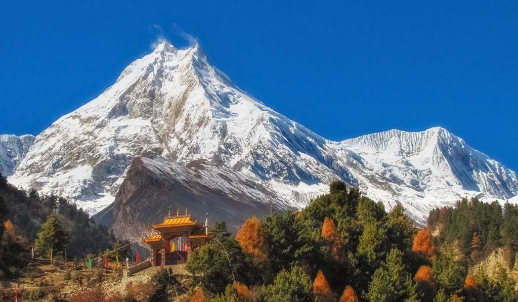
Mount Manaslu rises to 8,163 meters (26,781 feet), making it the eighth-highest mountain in the world. It belongs to the group of ‘eight-thousanders,’ a category of peaks known not just for their altitude but also for the level of experience required to climb them.
These mountains have long drawn climbers who are looking for something beyond standard high-altitude trekking. Even so, Manaslu is seen as more approachable than some of the more technically demanding peaks, though it is still hard.
Mount Manaslu Location in the Himalayas
Seen within the wider geography of Nepal, Manaslu sits in a part of the country that still feels relatively undisturbed. Gorkha, where the mountain lies, stretches from low river valleys to high alpine terrain, which is why the landscape changes so noticeably along the route.
For readers asking where is Manaslu in Nepal, this wider setting matters just as much as the exact pin on the map. There’s no direct flight into the Manaslu region either. Getting there usually means a long drive out of Kathmandu, followed by the trek itself. It takes time, and that alone keeps the number of visitors lower.
Map of Mount Manaslu and Surrounding Area
If you look at a map of Mount Manaslu, it sits within a tight cluster of peaks in the Mansiri Himal range. Nearby mountains like Himalchuli, Ngadi Chuli, and Shringi Himal are all part of the same group, which is why the area feels so compact when you see it laid out.
What makes the layout easier to understand is the Budhi Gandaki valley. It runs south of Manaslu and, in many ways, acts like a natural pathway into the region. Most trekkers end up following this valley as they move deeper into the mountains.
Once you start looking at it like that, the map of Mount Manaslu location makes more sense. The peaks, the river, and the route all connect in a way that feels quite straightforward, even if the terrain itself isn’t.
And that’s also why the journey doesn’t feel broken into separate sections. Unlike regions with multiple access points, the Manaslu route more or less follows a single natural line shaped by the river and the surrounding terrain.
Manaslu Region in Nepal: What Defines It
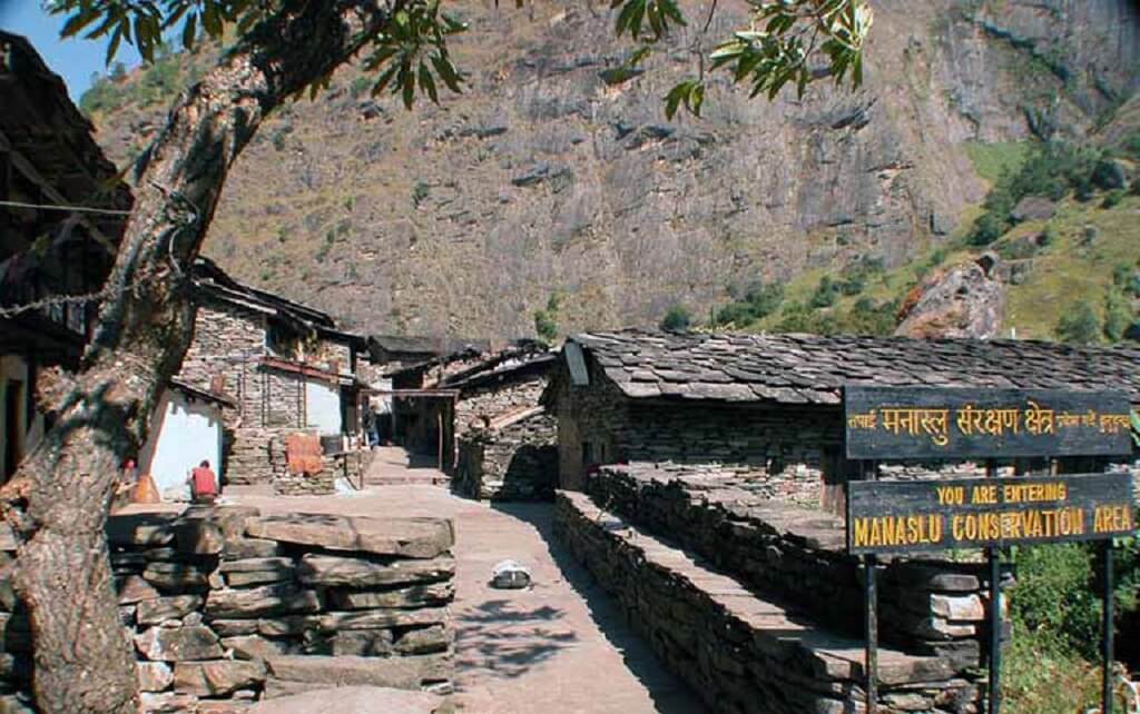
The Manaslu region Nepal refers to the broader area surrounding Mount Manaslu, including its valley, villages, and trekking routes. The area around Mount Manaslu is part of the Manaslu Conservation Area, which covers roughly 1,663 square kilometers.
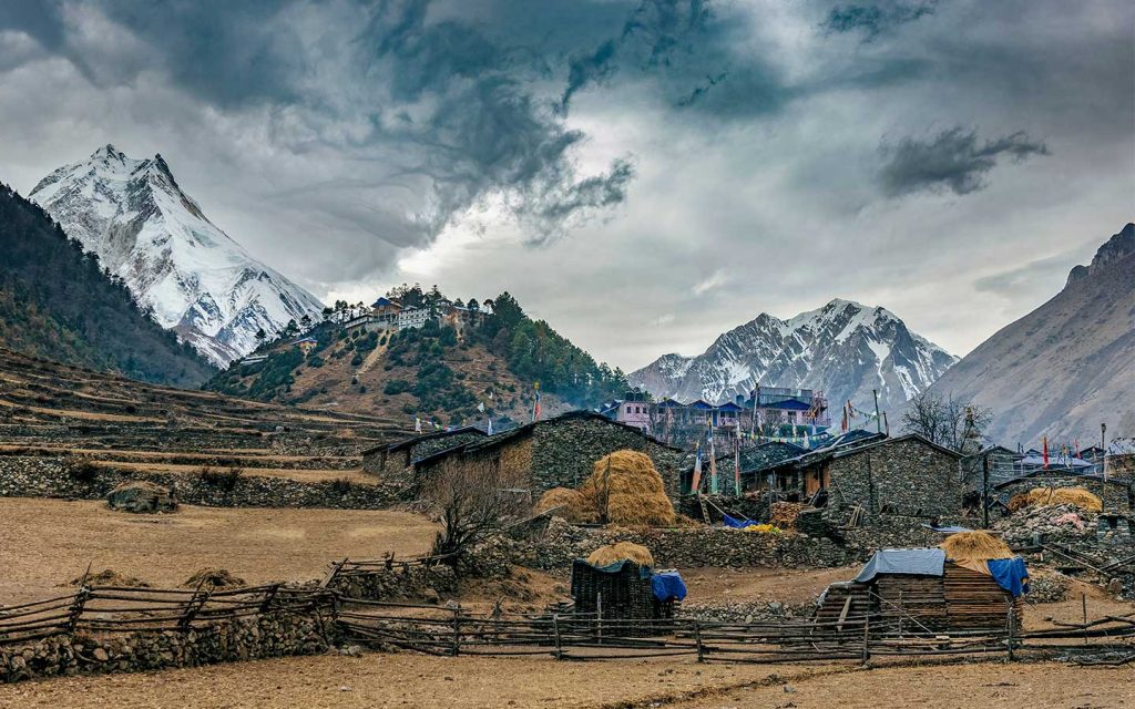
This isn’t just a protected landscape on paper. As you move through the region, you can actually see how varied it is. The lower parts have forests and farmland, and as you go higher, the vegetation thins out, and the terrain becomes more rugged.
The area is also home to wildlife like Himalayan tahr and, if you are lucky (or very patient), even snow leopards. Alongside these, there are small mountain communities that have been living here for generations, following their routines and traditions.
There are some controls in place for visitors — permits, limited access, that sort of thing. While these requirements may seem restrictive at first, they play a key role in preserving the region’s character and preventing overdevelopment.
Because of these protections, the Manaslu region has avoided the rapid commercialization seen in other trekking areas of Nepal.
Terrain and Landscape Around Mount Manaslu
The terrain here isn’t one single type — it keeps changing as you move through it. In a matter of days, you pass through the following:
- Deep river gorges
- Narrow valleys shaped by glaciers
- High mountain passes
- Long, exposed ridgelines
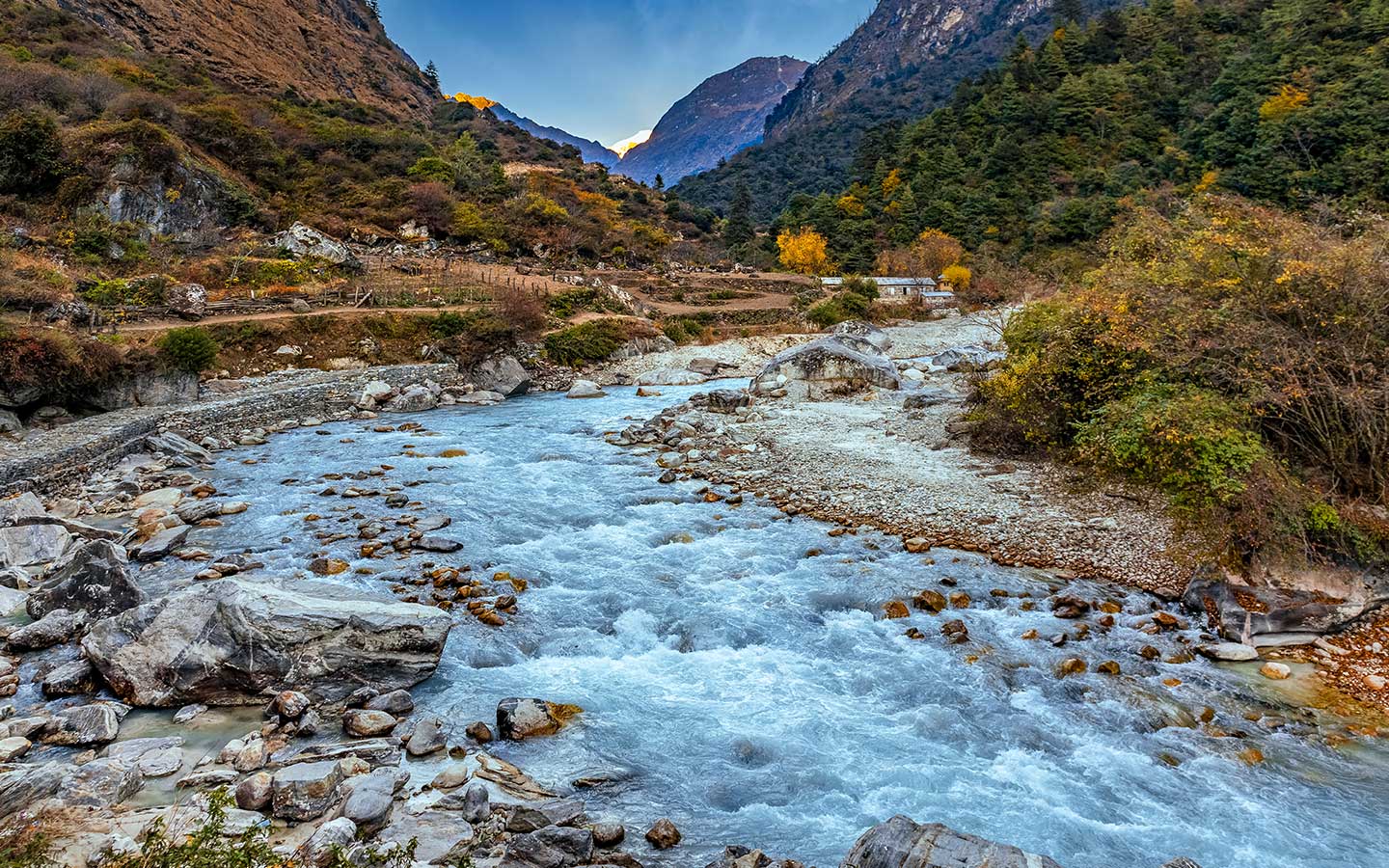
The Budhi Gandaki River more or less guides the whole route. It cuts through the landscape and creates the natural path that the budget Manaslu trek, as well as the standard trek, follow. Most of the early part of the journey stays close to this river before the trail starts gaining height.
As you go further north, the shift is quite obvious. The lower sections are greener, with trees and small settlements, but that slowly fades. As you go higher, the area opens up. There are fewer trees, more rocks, and eventually snow as you get closer to the top.
This constant transition is one of the features of the Mount Manaslu location. It makes the journey feel dynamic rather than repetitive. Likewise, it also reflects the wide elevation range of the region, which spans from around 700 meters to over 5,000 meters along the trekking route.
Climate and Elevation Zones Around Mount Manaslu Location
The Mount Manaslu location covers a big elevation range, but you don’t really think about it in numbers when you are there. You just feel it changing day by day.
At the start, down in the lower valleys, it’s warmer than people expect. The air feels humid, with greenery everywhere and villages surrounded by fields. It doesn’t immediately feel like you are heading toward a high mountain.
Then gradually, without a clear moment where it switches, things begin to shift. The trees start thinning out, the air feels lighter and cooler, and the landscape opens up. You walk a bit longer between settlements, and the surroundings feel quieter, less enclosed.
Higher up, especially as you get closer to places like Larkya La Pass (5,106 m), it’s a different environment altogether. It’s colder, the wind picks up, and most of what you see is rock, ice, and wide, open ground. There’s not much growing up there, and the terrain feels more exposed.
What stands out is how slow the transition is. It doesn’t feel like crossing zones — it feels like moving through them without really noticing when one ends and the next begins. And that slow shift is part of what makes the walk interesting, even on longer days.
Why Mount Manaslu Location Feels Remote
Mount Manaslu feels remote mainly because it takes time to reach and is not directly connected by flights or major road access. You don’t really think about location in detail at first, but once you are in the Manaslu region, it starts to explain a lot — how the journey feels, how the landscape changes, and even how people live here. This is where the location of Mount Manaslu starts to make practical sense, not just geographic sense.
A few things stand out along the way:
- Getting there takes time: There’s no quick access point, so the journey begins with a long drive and then continues on foot. It feels gradual rather than rushed.
- Subtle cultural influence from nearby Tibet: As you move higher, you start noticing small shifts — in architecture, in religious spaces, and in everyday life.
- The landscape keeps changing: You don’t stay in one kind of terrain for long. The lower sections feel greener, but that slowly gives way to more open, rugged ground as you gain height.
- The trail feels continuous: You are not moving between heavily developed stops. It’s more of a steady walk through the valley and up into the mountains.
None of this stands out in isolation, but together, it’s what gives the Manaslu region its distinct feel. The lack of quick access routes and limited infrastructure naturally reduces crowd levels, which is why the area still feels relatively untouched.
How Close is Mount Manaslu to Tibet?
Mount Manaslu lies quite close to the border with Tibet, though it remains entirely within Nepal. As you move higher into the region, you begin to notice subtle cultural influences from Tibet. This is visible in architecture, prayer flags, monasteries, and the everyday lifestyle of local communities.
Rather than a sharp divide, the transition feels gradual, blending geography and culture together. In higher villages like Samagaun and Samdo, this influence becomes especially noticeable, reflecting long-standing trade and cultural connections across the border.
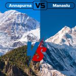
Is Mount Manaslu Near Annapurna?
Yes, Mount Manaslu sits about 60 to 65 kilometers east of Annapurna I. On a map, that doesn’t seem like much distance, but it doesn’t really feel that close when you are there. The terrain between the two — deep valleys, ridgelines, and separate access routes — keeps them quite distinct.
Annapurna is easier to get into and has more developed infrastructure along the trail. Manaslu, on the other hand, still feels quieter and less built-up. The approach takes longer, and you notice the difference in how busy or not busy the route is.
That contrast is actually what draws many trekkers in. It’s not that one is better than the other, but Manaslu tends to appeal to people who want a bit more space on the trail while still getting the kind of mountain views you come to Nepal for.
How To Reach Mount Manaslu Location
Getting to Mount Manaslu isn’t something you do quickly. The journey usually begins in Kathmandu, with a long drive out toward Machha Khola, which is where the trek typically starts. For anyone searching for how to reach Mount Manaslu, this overland approach is the usual starting point.
The road journey takes several hours, depending on traffic and conditions. The first part is on a proper highway, but as you move closer to the hills, the road becomes narrower and rougher.
From Machha Khola, the road ends, and the walk begins. The trail follows the Budhi Gandaki valley, gradually moving deeper into the mountains over the next few days.
This combination of road travel followed by trekking is what makes accessing the Mount Manaslu location feel gradual and immersive rather than rushed. Most itineraries take around two weeks or more, allowing time for acclimatization and a steady progression through the landscape.
Mount Manaslu and the Manaslu Circuit Experience
For most people, the Mount Manaslu location isn’t something they experience by going straight to the mountain. It’s the Manaslu Circuit that brings you into the region, almost indirectly. You don’t approach the peak head-on — you move around it, and that changes how you see the landscape.
The trail begins along the Budhi Gandaki valley, and for the first few days, the river is almost always somewhere below you. The path stays relatively low at first, then slowly starts gaining height. There’s no sudden jump — it just builds day by day as you pass through villages like Samagaun and move further north.
By the time you get higher up, the surroundings start to feel more open. The valleys widen, the peaks feel closer, and there’s less in between you and the mountains. Crossing Larkya La Pass (5,106 meters) is usually the toughest stretch, but it’s also the point where everything opens out — wide views, snow-covered ground, and a sense that you have crossed into a different side of the range.
What tends to stay with people, though, isn’t just that one moment. It’s how the whole route unfolds. The days don’t feel separate in a neat way — they blend into each other. One section leads into the next without much interruption, and before you notice it, you are much deeper into the region than where you started.
Best Time to Visit the Mount Manaslu Region
If you are thinking about timing your visit to the Mount Manaslu location, it really comes down to the weather. The location isn’t somewhere you want to gamble with unpredictable conditions, especially once you get higher up.
Most people end up going in either spring (March to May) or autumn (September to November), and there’s a reason for that. These are the best months for the Manaslu trek when the weather tends to hold steady and the views are actually worth the effort of getting there.
- Spring: This season feels a bit softer overall. The lower sections are greener, there’s more life along the trail, and the days are generally comfortable for walking. It’s not perfect every day, but it’s reliable enough.
- Autumn: Autumn is usually clearer. The skies open up more, and the mountain views are sharper, especially after the monsoon has washed the dust out of the air. That’s why many trekkers prefer it, even though it can get busier than spring.
- Winter: It is possible to go there in winter (December to February), too, but it’s a different experience. It gets noticeably colder as you move higher, and around Larkya La, snow can make things unpredictable—sometimes slowing you down and other times even blocking the route altogether.
- Monsoon: From June to August, the lower trails turn muddy and slippery, which can make walking uncomfortable. Frequent rain also affects visibility, so the journey can feel slower and a bit more challenging overall.
In the end, timing matters more here than people expect. Because of where Manaslu sits, the weather shifts are quite noticeable, and picking the right season can make the whole journey feel either smooth or unnecessarily difficult.
Why Mount Manaslu Location Matters for Trekkers
Once you are actually on the trail, a few things start to stand out — not all at once, but gradually as the days go by:
- Getting there takes time
- Cultural influence increases with altitude
- The landscape keeps changing
- The trail feels continuous
None of these feels like big moments on their own, but together they shape the whole experience. You notice the slower pace, the unhurried trail, and the region’s less developed routes.
For many trekkers, that’s exactly the point. The Mount Manaslu location offers a kind of balance in Nepal’s trekking landscape — you still get the scale of the mountains, but without the constant flow of people. And at the same time, there’s a cultural side to the journey that feels present without being overdone or commercial.
It’s not something that stands out immediately, but after a few days, it becomes clear why people choose this region in the first place.
Final Thoughts
On paper, it is straightforward — Mount Manaslu is in Gorkha, in Nepal, within the Mansiri Himal range. But once you start looking at it beyond the map, that answer feels a bit too simple.
This is a part of the Himalayas where things don’t happen quickly. Just getting there takes time, and that already sets the tone. The landscape doesn’t change all at once — it shifts slowly as you move, almost without you realizing it.
After a few days in the region, you begin to understand why it feels different. It’s not just the mountains; it is also the distance, the pace, and how everything around it feels a little removed from the usual rush.
This is really what defines the Mount Manaslu location — not just where it sits on the map, but how it feels when you’re actually there. It is not just geography; it shapes the experience. The journey matters here, and the mountains feel closely connected to the land and the people around them.
FAQs
Where is Mount Manaslu located?
Mount Manaslu is in Nepal’s Gorkha District, part of the Mansiri Himal range, quite close to the Tibetan border.
Where is Manaslu in Nepal?
Mount Manaslu lies in north-central Nepal, in Nepal’s Gorkha district, within the Mansiri Himal range near the Tibetan border.
How high is Mount Manaslu?
It stands at 8,163 meters (26,781 feet), which makes it the eighth-highest mountain in the world.
Which region does it fall under?
It’s part of what’s commonly called the Manaslu region — a quieter part of the Himalayas known for trekking rather than heavy tourism. This wider area is often referred to as the Manaslu region of Nepal.
How do you actually get there?
The journey usually starts with a drive from Kathmandu to Machha Khola. From there, the road ends, and the trek begins. That is the usual answer for travelers searching for how to reach Mount Manaslu.
Is Mount Manaslu close to Annapurna?
Yes, it’s about 60–65 kilometers east of Annapurna I. Even though the distance isn’t huge, the two regions feel quite different because of the terrain in between.