
Island Peak, which people in Nepal call Imja Tse, is a beloved climbing mountain that reaches 6,189 meters (20,305 feet) in the Solukhumbu area. Because it is in the Himalayan range, you can get a good idea of high-altitude climbing as you combine ice climbing with exciting hiking. First, you make your way from Lukla on the well-known Everest Base Camp path to Namche Bazaar, Tengboche, Dingboche and Chhukung, continuing to Island Peak Base Camp.
During the Island Peak Climbing, you can visit various terrain like villages, forests, open ice and glaciers. Rope-assisted climbing, crossing glaciers and avoiding crevasses on the summit make it possible for seekers of adventure to attempt this peak. A highlight of climbing here is the breathtaking summit view with Everest (8,849m), Lhotse (8,516m), Ama Dablam (6,812m), Nuptse (7,879 m) and Makalu (8,485m) in sight, along with other impressive Himalayan giants.
Island Peak is a practice area for people preparing for big climbs in the Himalayas, thanks to its itinerary that helps them become used to the high altitudes. Many climbers go ice climbing and learn essential rope skills, gathering important mountaineering knowledge. Visiting the traditional villages and monasteries in Sherpa communities, along with other historical sites, helps to understand the strong and rich traditions of the people from high altitudes.
Visiting during March to May or September to November is ideal and to succeed, you should reserve permits, collect needed equipment and hire trained guides. Island Peak Climbing attracts climbers of all skill levels with its exciting ascent, focus on improving your skills and amazing views of the Himalayas.
Why Island Peak Climbing?
Island Peak Climbing is a good choice for mountaineers who want a tough adventure without being too difficult to reach. Having climbing skills is recommended, yet anyone who is a strong trekker can still handle it. The trail takes you through forests, onto glaciers, across high ridges and even bare ice slopes for a truly good mountaineering experience.
The summit offers a breathtaking view that covers Everest (8,849m), Lhotse (8,516m), Makalu (8,485m) and Nuptse (7,861m). Passing through Sherpa villages like Namche Bazaar, Tengboche, Lobuche and so on, old monasteries and isolated towns in the high mountains gives climbers a rich cultural experience. Island Peak is a suitable choice for altitude practice because it is easier and cheaper than climbing Everest or other 8,000m peaks.
Highlights during the trek
- Climb to the top of Island Peak and appreciate the dramatic views of the Himalayan peaks like Everest (8,849m), Lhotse (8,516m), Makalu (8,485m) and Nuptse (7,861m).
- See how Sherpa culture is alive in Namche Bazaar as both climbing history and modern trekking come together.
- Visit Tengboche Monastery to admire the peaceful atmosphere and see the nearby grand peaks of Everest, Ama Dablam and Lhotse.
- Spend time noticing the huge changes in the surrounding scenery, from thickly forested areas and riverbeds to uninhabited glacier areas.
- Go across the Chhukung Glacier, watch out for ice-covered ridges and deep holes and climb up steep paths to the Island Peak Base Camp.
- Enjoy seeing many different species in the Himalayas, for instance, snow leopards, Himalayan thar and Danphe (Nepal’s national bird.)
- Get pumped by the adventure as you climb, secured by ropes, on icy walls and ridge lines for the last part of the ascent.
- Feel the peace in Chhukung Valley with the background of sky high mountains and wild Himalayan nature.
- Explore cross suspension bridges above the Dudh Koshi River which flows through wide gorges and creates amazing waterfalls below.
Detailed Island Peak Climbing Itinerary
Today, we wrap up logistics to ensure that you have everything you need for a completely smooth and successful trek. We will help you apply for your trekking permit(s), namely the Sagarmatha National Park Permit and Khumbu Pasang Lhamu Rural Municipality Permit at the Nepal Tourism Board. Thamel is the best place to rent or buy trekking equipment if you need some additional gear.
You will also have an opportunity to visit some of the most noted cultural sites of Kathmandu such as the magnificent city views at Swayambhunath Stupa (Monkey Temple) or nature of Asan Bazaar where locals trade things such as spices and textiles.
Because Island Peak requires specialized climbing equipment, your guides will give you a briefing session to make sure you have everything you’ll need before you head into the mountains. It’s your evening to relax, enjoy Sherpa hospitality and get yourself ready for the days ahead.
Altitude Loss: -250 m
Flight Duration: 35 to 40 mins
Trek Distance: 8 km
Trek Duration: 2 to 3 hrs
We take a spectacular flight into the Himalayas to Lukla, the most famous place for the Tenzing Hillary Airport, one of the most thrilling airstrips in the world and your journey to the Himalayas begins.
Upon landing, you’ll find yourself among the most beautiful mountain scenery which will make the perfect start to our adventure. We trek down from Lukla towards Phakding, a beautiful village on the Dudh Koshi River. We’ll cross suspension bridges decorated with prayer flags, pass Mani walls covered with Buddhist prayers and see Sherpa houses that have been traditional for hundreds of years.
This first day of trekking is a gentle lead-in, to give you time to adjust while you admire the wonderful places of this emerging world. Along the way we will stop at local tea houses where you can enjoy a warm meal, including the staple Nepali dish dal bhat, before taking in the rest of the day.
About Lukla
Sitting at an elevation of 2,860 metres , Lukla is the gateway to the Everest region and with natural beauties. Most famous for its Tenzing-Hillary Airport, it is one of the world’s most dramatic airstrips, its short runway and variable weather making for exhilarating experiences.
The adventure of starting a trek in the Himalayas itself and watching planes land and take off from here makes it all the more exciting. Trekking shops, cafes and lodges where travellers can rest, pop into, purchase last-minute gear and come into contact with local people fill the town.
There are opportunities to explore Lukla Monastery, a serene place which embodies the spiritual aspects of Sherpa culture or a short walk to enjoy a wide angle view of valleys and peaks.
And until recently, Lukla was isolated as a remote farming village, only used for pasturing and trading with Nepal and northern Tibet. In 1964, the airport was built with the support of Sir Edmund Hillary turning the region into a trekking hub and ushering in modern tourism in the region.
Key for today’s trekker or mountaineer heading to Everest, Lukla is still both a Sherpa experience and a logistical base. As such, anyone making their way through the Himalayas should stop here for a little adventure, history and tradition in perfect balance.
About Phakding
A small, but important, village in the Khumbu region, Phakding lies at an altitude of 8,560 feet (2610 m) on the banks of the Dudh Koshi River. As the first major stop for those trekking to Everest Base Camp it provides a comfortable rest before the difficult climb to Namche Bazaar. There are lush forest, terraced fields and towering mountains surrounding the village, making it a beautiful area.
The Phakding Monastery is a small but culturally rich Buddhist site that tourists can visit, for locals to gather for prayers. The village is famous for suspension bridges, lovely with prayer flags and stunning views to the river and home feel. Visitors can experience the culture of the Sherpa and get to interact with the locals as well as enjoy the tranquility of the Himalayan foothills, with short hikes around Phakding.
Phakding was historically a trading post where Sherpas and Tibetan merchants from Tibet would trade salt, wool and livestock. Through time it developed into a trekking hub with guesthouses and lodges that made way for the more adventurous travellers.
However, Phakding, as it stands now, still serves as an important stop for acclimatization, with a perfect mix of natural beauty, cultural heritage and trekking comfort. Because of its involvement in the Everest trekking route; it is a must visit place for all those who have laid their footsteps in the Himalayas.
Altitude Gain: +830 m
Trek Distance: 10-12 km
Trek Duration: 6-7 hrs
Today, we trek further up into the mountains climbing towards Namche Bazaar, the bustling crossroads to Everest and the Sherpa heartland. The trail runs along the Dudh Koshi River, through rhododendron forests, over several suspension bridges, notably the Hillary Suspension Bridge.
We then enter into the protected Himalayan region at the Sagarmatha National Park entry gate as we switch into even more beautiful landscapes. Namche is a climb, but seeing those first absolutely breathtaking views of Namche Bazaar and towering peaks, including Everest itself, makes it worth it.
When you arrive in Namche Bazaar, you’ll have all the amenities of a lively marketplace with cafes, bakeries, trekking shops, lodges and as many adventurers around the world come here to experience the trek. We will get ready for tomorrow to take a short acclimatization hike to the Everest viewpoint from where we will hope to see an amazing panorama of Everest, Lhotse, Ama Dablam and others.
Known as a trade hub for Tibetan goods, Namche still serves as a major staging area for trekkers preparing for high altitude expeditions. The evening is yours to peruse, unwind and drink warm cups of butter tea while recounting trekking stories with other explorers – the voyage towards the Himalayas starts.
About Namche Bazaar
At 3,440 meters above sea level, Namche Bazaar is at the center of the Khumbu region and the most important trading site for those going to Everest Base Camp. Surrounded by a valley that looks like a theater, Khumjung provides beautiful sightings of the peaks Kongde Ri and Thamserku.
The Sherpa Cultural Museum offers tourists a view of the Sherpa people’s history, customs and important role in mountaineering. A quick visit to The Everest View Hotel will reward you with impressive views of Everest, Lhotse and Ama Dablam.
In Namche, you’ll find cafes, bakeries, shops for trekking and even an Irish pub, making it a cheerful place to relax. On Saturday mornings, there is a weekly market in the town where people from Tibet and nearby villages exchange items such as fruits, vegetables and hiking gadgets.
Namche Bazaar originally began as a market, where salt, wool and yak cheese were traded between Tibetan and Nepali traders. In the 1950s, trekking tourism brought many travelers and Kathmandu played a big role by providing hotel rooms and supplies for climbers.
In today’s time, the trekking route can bring you to the high Himalayas, mixing modern needs with the influence of Sherpa culture. Because of its prime location, old history and breathtaking scenery, Namche Bazaar is a must-see destination in the Everest area.
Altitude Gain: +400 m
Altitude Loss: -400 m
Trek Distance: 3-5 km
Trek Duration: 3-4 hrs
On this day, we will remain in the town of Namche Bazaar to help your body get ready for further ascent in the Himalayas. Because of acclimatization, you won’t experience altitude sickness and can fully appreciate the culture in this lively Sherpa town which has helped connect the surrounding region for centuries.
After breakfast, we go for a short walk to Everest View Hotel, where you can enjoy seeing Everest, Lhotse, Nuptse and Ama Dablam. You can get amazing panoramas here and enjoy the impressive sight of the surrounding mountains.
Then, you can go to the Sherpa Cultural Museum to find out about the interesting heritage, climbing skills and history of Everest in Sherpa culture. The museum keeps collections of items used by first climbers and highlights how important Sherpas have been for mountaineering above 8,000 meters.
With lots of energy, the Namche Bazaar Market sells trekking needs, souvenirs and cozy cafes where you can pick up hot Himalayan coffee. Earlier, Namche was known as a place where merchants from Tibet traded salt, wool and yak cheese. Now, Namche Bazaar is still at the heart of everything to do with trekking in the region.
Buddhist monks pray in daily sessions at the Namche Monastery which is popular with those who want a spiritual experience. In the evening, you can rest, meet the other hikers and drink yak butter tea to prepare for what’s coming next.
Altitude Gain: +427 m
Trek Distance: 9 km
Trek Duration: 5-6 hrs
Following a full day of getting used to the altitude, we trek on, passing through amazing Himalayan sights and cultural attractions toward Tengboche. The adventure begins with a walk along a light, scenic route that allows views of Everest, Ama Dablam, Thamserku and Kangtega, turning the start of the day into an adventure. When we walk among the rhododendrons, we find lovely greenery that is far from the craggy terrain ahead of us.
We pass a small settlement by Phunki Thenga where we stop and have a break over tea before crossing a wooden river bridge over a Dudh Koshi. It is at this point that you begin an unrelenting climb up to Tengboche.
Near the top, we come to the Tengboche Monastery, the main and most significant monastery in the region. It was first established in 1916 and has been reconstructed many times after earthquakes and fires, yet remains important to trekkers and mountaineers.
Daily prayers are held here by monks and blessings are offered to those making the trek into the Himalayas. The Monastery became famous because of the annual Mani Rimdu Festival which celebrates Tibetan Buddhism. When we finish our visit, we climb up to the mirador and watch the sunset behind Ama Dablam. After arriving at our lodge, we take it easy, talk about what we have experienced and get our bodies ready for going higher.
About Tengboche
Tengboche is a beautiful village found in the Khumbu region at 3,867 meters above sea level. Many people recognize it for the Tengboche Monastery which is both the most significant and biggest Buddhist monastery in its region. Located close to impressive mountains like Everest, Ama Dablam, Nuptse and Thamserku, Tengboche offers some of the best views around and is a favorite for trekkers.
Visitors can stop at Tengboche Monastery, where monks are dedicated to daily prayers, making it serene and spiritual. Each October, the Mani Rimdu Festival occurs at the monastery, with colorful masked dances, ritual prayers and blessed activities. People visiting can walk short distances to nearby lookout points, appreciate the rhododendron forests and experience the famous hospitality of the Sherpas.
The site of Tengboche began as a spiritual center in 1916 after Lama Gulu received a prophecy confirming it was meant for a monastery. The building collapsed after an earthquake in 1934, but it was rebuilt, only to be destroyed by fire in 1989.
International support enabled its reconstruction so its cultural and religious importance was maintained. The area of Tengboche is still considered holy to the Sherpas and those who hike there, mixing spiritual purpose, age-old traditions and astounding views.
Altitude Gain: +504 m
Trek Distance: 10 km
Trek Duration: 5-6 hrs
Today, we are heading towards mountain summits, leaving the forests to step into the alpine zone. The morning commences with a hike down to Deboche, passing by many old chortens and prayer flags in the pretty village, where you then cross a suspension bridge leading to Pangboche, the highest village in Khumbu all year round.
This village is where you’ll find the Pangboche Monastery, the oldest in Everest, said to have relics from the Yeti. In the past, many Sherpa traders and Tibetan pilgrims would stop at this village which is why it became a special stop on the trek. Going higher still, everything becomes less populated by plants and we enter Pheriche, where the ground is rocky and rivers are fed from glaciers above.
The Himalayan Rescue Association (HRA) clinic at Pheriche is renowned for treating both trekkers and climbers with altitude sickness. Since being created in the 1970s, it has grown to be important for education and emergency services. Around this region are the impressive mountains Taboche, Cholatse and Lobuche Peak, creating a magnificent view.
In the afternoon, we relax and let our bodies get used to the height, so we are set for what lies ahead. Visiting the HRA center will allow you to understand high-altitude physiology and eat in one of the nearby teahouses. Before making the last leg to Everest Base Camp, many groups make Pheriche their most important acclimatization point.
About Pheriche
Pheriche is a village located high in the Khumbu region at an altitude of 4,371 meters. This place is important for trekkers on their way to Everest Base Camp, as it lets them see the stunning Ama Dablam, Lhotse and Khumbu Glacier. Because the Himalayan Rescue Association (HRA) clinic is found here, the village is very useful for those trekking, as the clinic helps with medical care and altitude sickness.
Travelers are welcome to visit Sherpa teahouses, meet local people and take in the peaceful surroundings of the range. The area surrounding Pheriche provides quick hikes, letting you enjoy wonderful views of glacial rivers, meadows and rocky landscape. Visiting the village is a nice way to know about the Sherpas, since you can visit their monasteries and take part in their customs.
As recounted in history, yaks were farmed here along with potatoes and buckwheat by the Pheriche community. In the end, the region turned into a place where guides and porters from Sherpa communities participated in many climbs of Mount Everest.
Despite the destruction caused by the 2015 earthquake in Nepal, Phakding is again thriving, supporting many trekkers. Currently, Pheriche maintains its function as a base for hikers, thanks to the area’s natural surroundings, rich tradition and convenience.
Altitude Gain: +569 m
Trek Distance: 8 km
Trek Duration: 5-6 hrs
From Pheriche, we head for Lobuche, going through remarkable glacial scenery and rocky moraines. Dughla Pass appears on the route which serves as a memorial spot for climbers who have passed away while trying Everest. They honor great mountaineers Scott Fischer and Rob Hall, making trekkers aware of what can happen in high-altitude mountain ranges.
After going over the tough, rocky Dughla Pass, we start to see the Khumbu Glacier, a huge mass of ice that frequently moves because of climate change. The glacier is responsible for the rivers that shape the mountainous features of the Everest region we have passed through.
When we reach Lobuche, there are impressive Lobuche East and Lobuche West peaks all around us which are only for climbers with more advanced skills. Previously, Everest climbers used Lobuche as their final stop before heading to Gorak Shep and Everest Base Camp. Nowadays, most trekkers use this point to prepare, rest and build their strength for the next part of their journey.
We enjoy having a break in our lodge, sitting to a delicious hot supper and admiring what we’ve accomplished as we climb upwards to the highest mountain in the world. We are heading to Everest Base Camp tomorrow which everyone on our expedition has been waiting for.
About Lobuche
Lobuche is an area above 4,900 meters, situated near where the Khumbu Glacier begins. It is a favorite tent stop for those hiking to Everest Base Camp because of the impressive views of Nuptse, Pumori and Lobuche Peak.
People visiting can visit Lobuche Memorial Park and discover the many stone monuments erected to honor climbers who died climbing Everest. Climbers can use the village to get used to the height and can enjoy short treks with stunning views of the neighboring glaciers and rough land. Regardless of how inaccessible it may seem, Lobuche has places for trekkers to relax before they keep going.
In the past, Lobuche was only used during the yak herding season, but it has grown into a main spot for those involved in Mount Everest expeditions. At Thukla Pass, you’ll find memorials for many famous mountaineers, making the area valuable and thought-provoking. Lobuche lies at such a high elevation that the weather is always cold and very windy. There are no roads to the village, so clothing and supplies are brought in by yaks and porters.Lobuche is still a key transitional point in climbing, bringing together stories of mountaineers, lovely surroundings and an uncomplicated trek. Because it is so close to Everest Base Camp, adventurers in the Himalayas can’t miss visiting this place.
Altitude Gain: +424 m
Altitude Loss: -200 m
Trek Distance: 12 km
Trek Duration: 6-8 hrs
We hike over rocky ground and glacial debris in the morning, heading toward Gorak Shep, the village just before Everest Base Camp. Viewing Nuptse, Pumori and Lingtren on the trek offers travellers a sense of how massive the Himalayas truly are.
At Gorak Shep, we spend a little time resting before proceeding to Everest Base Camp, the highlight of our walk. The route goes along the Khumbu Glacier, a huge and changing glacier that climbers must negotiate during their quests to summit Everest. At 5,364 meters above sea level, you’ll see a base camp with lots of colorful expedition tents, prayer flags and towering ice formations in the background.
It feels meaningful to be here, as the climb to Everest summit begins here. You can take some photos, enjoy the outdoor scenery and feel the excitement of those starting their climb. We head to Gorak Shep after base camp, enjoy our night at the lodge and get ready for the early climb to Kala Patthar tomorrow morning.
About Gorakshep
Gorak Shep is found in the Khumbu region, at the altitude of 5,164 meters, just above the point where Everest Base Camp begins. This place sits on a frozen lake under sand which gives it a special and rugged feeling for trekkers. Even though Gorak Shep is nearly 5,300 meters high, it has lodges and teahouses where adventurers to Everest can stay safely.
People visiting can hike, ski or climb the Khumbu Glacier to see the incredible views of Everest, Nuptse and Pumori. It takes between 1.5 and 2.5 hours to go from Gorak Shep to Everest Base Camp, depending on the weather and how well you have adapted to the climate. Kala Patthar stands as a main attraction at 5,550 meters, letting interested hikers watch an amazing sunrise right above Mount Everest.Gorak Shep was initially the place climbers used as their Base Camp until the camp was situated closer to Everest in the 1950s. The name Gorak Shep is why the locals call it “deadravens,” reflecting the area’s lack of living things. Today, trekkers use this location as the beginning of their final journey to Everest Base Camp. The region’s difficult climate, beautiful views and mountain experiences make it attractive to anyone eager to explore the Himalayas.
Altitude Gain: +391 m
Altitude Loss: -825 m
Trek Distance: 15 km
Trek Duration: 8-9 hrs
Before the sun comes up, we climb to Kala Patthar, where you can see wonderful views of the mountain. While the path goes up steeply, it is worth it as you get to see Everest, Lhotse, Nuptse and Pumori in the open. This point, measuring at 5,555 meters, is the highest spot we reach and at dawn the golden light makes Everest and the landscape around it stunning.
After seeing the wonderful views and taking some pictures, we head down to Gorak Shep for our morning meal and then we continue on the way to Chukkung. The path takes you through the lovely Nangkartshang Valley, alongside rough terrain and open land. During our trek, we see Ama Dablam, Island Peak and Lhotse Wall, giving us a glimpse of what is ahead as we climb.
Taking time in Chukkung helps us adjust our bodies and minds for what lies ahead, with great views of glacial valleys and huge Himalayan mountains nearby. We use the evening to check over the tools we have and to plan how we will handle the Island Peak challenge.
Kala Patthar
Kala Patthar which means “Black Rock” in Nepali, is well known in the Everest region because it sits at 5,545 meters above sea level. Because it offers unrivaled sightings of Mount Everest, it is one of the top trekking spots in the area. Everest’s summit is often covered by the mountains of the Everest Massif, so from Kala Patthar, visitors get to see the side and summit of Everest, while also enjoying views of Lhotse, Changtse and Pumori.
Kala Patthar is usually reached from Gorak Shep and it takes trekkers about 1.5 to 2 hours to walk there. A symbol of the summit is the display of prayer flags, while its early morning light offers one of the most beautiful sunrises you can find in the Himalayas. It’s often used as an adjustment hike for those who want to improve their body before reaching higher altitudes.
Traditionally, climbers and trekkers have used Kala Patthar as a high viewpoint. In 2009, a historic cabinet meeting took place there, for which the government of Nepal discussed and addressed issues of climate change in the Himalayas.
At one time, this location held the record for having the highest webcam which took pictures of Everest live. Currently, Kala Patthar is a well-known trekking place, famous for its stunning views, deep history and hard yet satisfying climb.
Altitude Gain: +400 m
Altitude Loss: -400 m
Trek Distance: 3-5 km
Trek Duration: 3-4 hrs
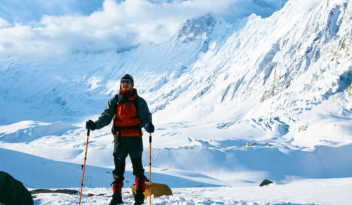
Today, we allow our bodies to rest in Chukkung before heading upward to Island Peak Base Camp tomorrow. Since the climb will get higher, preparing our bodies is very important for a successful climb to the summit.
The village of Chukkung is at an elevation of 4,730 meters and is set among Himalayan heights and valleys fed by glaciers. Many climbers use this stop on their way to Island Peak, Lhotse and Ama Dablam which makes it a popular site for mountaineers.
A short acclimatization hike to Chukkung Ri (5,546 m) during daytime is recommended, since it offers amazing views of several famous trekking mountains: Makalu, Lhotse, Baruntse and Ama Dablam. It helps your body get used to the conditions as you discover some of the pleasures of high-altitude trekking.
In Chukkung, those who stay can work on their climbing techniques, check the gear together and decide on the best route to the summit with their guides. For a long time, the settlement was an important station for traders, trekkers and climbers on their trips through the Everest passes.
In the afternoon, we take a break and drink enough water to get ready for the run. There’s time for healthy meals, sharing stories with climbers and preparing for the coming challenge. Once evening comes, we take a break in our lodge before making our way to Island Peak Base Camp.
About Chukkung
Chukkung is located far up in the Khumbu region at an altitude of 4,730 meters. Because of Lhotse, Nuptse, Ama Dablam and nearby Island Peak, it attracts many trekkers and climbers. Villagers use it as a starting point for Island Peak (Imja Tse) climbs and travelers going to Everest Base Camp typically acclimatize here.
At an altitude of 5,546 meters, the rocky Chukung Ri is open for tourists who want to have a great view of the Everest area. Imja Glacier can be found in the area and shows clearly how climate change affects the Himalayas. Visitors are welcome to try Sherpa tea and food, feel the warmth of hospitality in teahouses and walk to nearby places for viewpoints.
Chukkung is like a go-to area for livestock which means that there are no permanent communities there. Because more people started trekking and climbing, lodges were constructed specifically for guests. Even now, it is considered a prime place to take a breather and recover as you prepare for higher elevations. For those traveling through the Himalayas, Nepal’s beautiful landscapes, mountains and rich culture won’t be forgotten.
Altitude Gain: +470 m
Trek Distance: 6 km
Trek Duration: 6-7 hrs
After Chukkung, we start the trek to Island Peak Base Camp by walking over exciting, rough trails across high areas. We pass through moraines, over rocks and through icy terrain, enjoying beautiful views of Imja Glacier, Amphu Lapcha and Baruntse along the way.
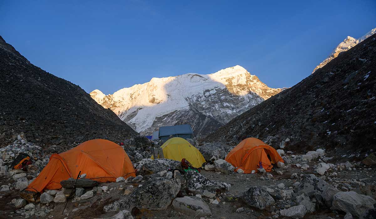
The Island Peak Base Camp at 5,200 meters is where climbers last prepare for their summit attempt. Traditionally, climbers heading to Everest have climbed Island Peak to get the essential mountaineering experience at an accessible altitude.
We reach our base camp and begin practicing everything needed for our climb such as climbing techniques, rope and harness use and ice climbing. This way, all climbers can be sure they are equipped properly for the following summit attempt.
During the evening, everyone arranges their gear, discusses the plan for the summit, studies the path and checks that everything is ready. There is much excitement and anticipation among climbers before they tackle one of their greatest climbs in the Himalayas.
Eating dinner early, we relax in our tents and make sure we are refreshed for our early morning rush to the top of Island Peak.
About Island Peak
Island Peak, called Imja Tse by locals, rises to 6,189 meters in the Khumbu region and allows you to see majestic views of Lhotse, Nuptse, Baruntse and Ama Dablam. Many people come to Nepal to climb this peak because it is both hard and attainable for most climbers.
Doing glacier climbing, roped ascents and technical ice climbing on this peak makes it ideal for people planning to climb higher areas. Starting at Island Peak Base Camp, trekkers have to manage rocky ridges, cross over crevasses and climb steep ice hills on their way to the top. Most climbers include the peak in their Everest Base Camp trek to give themselves time to get used to the altitude before ascending.
It was not until 1953 that Island Peak was climbed for the first time, by an expedition that then successfully summited Everest. Tenzing Norgay and Charles Evans were part of that group. Previously, it was mostly taken on by climbers who were preparing for Everest and this use has not disappeared. The name Island Peak comes from its appearance as a small island surrounded by ice, when seen from Dingboche.
At present, Island Peak is regarded as a hard but reachable mountain, where you need to have basic climbing skills and good fitness. Its excellent scenery, challenging routes and important background make it a vital destination for Himalayan adventurers.
Altitude Gain: +989 m
Altitude Loss: -1,459 m
Trek Distance: 10 km
Trek Duration: 9-10 hrs
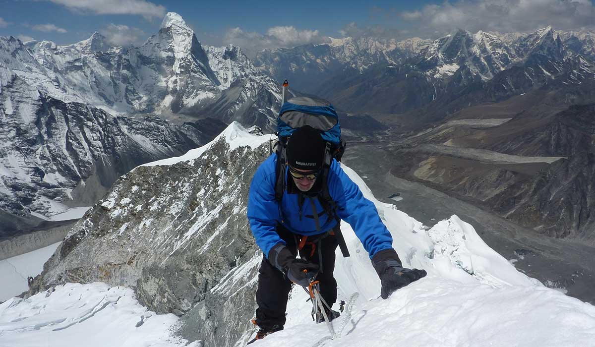
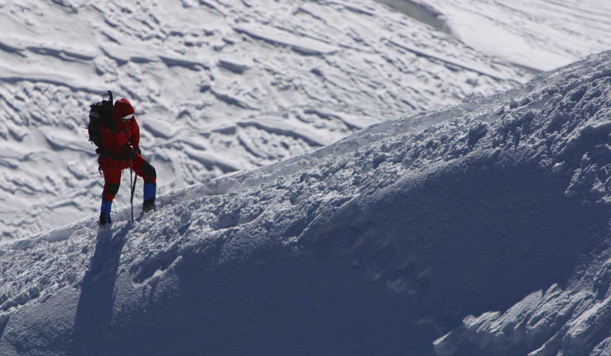
We leave our camp in the middle of the night so we can climb Island Peak while the stars are still shining. The early ascents are along rocky ridges and glaciers which makes it necessary to watch each step carefully as we get to the steeper parts. When we climb higher, the area becomes hard to navigate, so we have to use our ropes, crampons and harnesses to overcome the ice.
Getting to the peak at 6,189 meters is a thrilling experience, thanks to amazing views of Lhotse, Makalu, Baruntse and Ama Dablam all around. Standing on any of Nepal’s popular trekking peaks gives a sense of success that cannot be explained. The climb has a long history of preparing people for an ascent on Everest, as it helps build skills and get experience.
Following our time at the summit, we go carefully down, passing the same amazing glacial and rock areas we saw on the way up. After a short break, we keep going to Chukkung, check into the lodge and think back on everything we have accomplished. Today is a day to celebrate, as we have reached our goal and are about to make the last trek back.
Altitude Loss: -745 m
Trek Distance: 11 km
Trek Duration: 6-7 hrs
After leaving Chukkung, we start moving down through some of the most magnificent glacial valleys, heading for Pangboche which holds much significance for Sherpa culture. During the trek, you get up close to Ama Dablam, Lhotse and Thamserku which gives the journey an even greater appeal.
The lower air temperature changes takes us through lands of ice and finally into green meadows and rhododendron forests. We go by Dingboche, known for helping trekkers acclimatize to the altitude and then to Pangboche, an ancient village. Previously, the village was important for religious and commercial activities and many Tibetan merchants stopped there.
At Pangboche, you once again can visit the Pangboche Monastery. At this destination, you’ll be able to walk through the holy spaces and learn about the strong influence of Buddhism here. From the village, you can see Ama Dablam which is considered one of the prettiest mountains in the country.
Once we are at the Sherpa lodge, we enjoy the local company, share memories from our achievement and get ready for the next part of our hike back to Namche Bazaar.
About Pangboche
Pangboche is a village in the Khumbu region, at 3,985 meters above sea level. It is among the oldest communities in the Everest region and visitors can enjoy great views of Ama Dablam, Everest and Thamserku. This village is an important place for Everest Base Camp trekkers, as it blends heritage, religious value and beautiful surroundings.
Those traveling will be able to see the Pangboche Monastery, claimed to be the oldest in the Khumbu, from the 17th century. The monastery’s fame comes from its supposed yeti hand and skull, but the hand was taken more than 20 years back.
People can tour Sherpa houses, communicate with local people and discover the strong Buddhist traditions of the area. The route from Tengboche to Pangboche gives you brilliant views of Ama Dablam and makes it a notable highlight along the Everest trek.Traditionally, Pangboche acted as a center where Tibetan and Sherpa traders exchanged their goods. Sungdare Sherpa, a national hero and excellent climber, is from the village and he reached Everest’s peak five times. Visiting Pangboche now allows trekkers to experience Sherpa traditions, learn about their spiritual beliefs and enjoy the amazing scenery as they prepare for their hike to base camp.
Altitude Loss: -545 m
Trek Distance: 10 km
Trek Duration: 6 hrs
Progressing down the Dudh Koshi River, we hike through forests and enjoy lovely landscapes heading back to Namche Bazaar. When we go lower, the temperature rises, so we finally see the beautiful greenery and busy Sherpa villages.
Stopping in Tengboche, we take another look at the Tengboche Monastery where monks pray religiously every day. We can use this time to remember what we have experienced and enjoy the religious surroundings. There is one more chance to enjoy the sights of Everest and Ama Dablam from a different angle.
After arriving in Namche, fun cafes, bakeries and shops greet us, giving us the chance to cheer about finishing our expedition. In the past, Namche was the economic heart of the Khumbu and it still functions as the last key stop for trekkers before going to Lukla.
We end the night relaxing and enjoying what civilization has to offer before hiking to Lukla.
Altitude Loss: -580 m
Trek Distance: 19 km
Trek Duration: 7-8 hrs
In the last segment of the trip, we trek from Namche Bazaar to Lukla using the routes we used earlier to reach the Everest area. Going downwards, we go through Phakding and cross several delicate bridges, passing through the same points we started from.
Taking part in the trek gives us a moment to consider the sights we saw and the things we did together. During the hike, we also visit little villages and spend our last moments admiring the calm beauty of Sagarmatha National Park.
In Lukla, we all remember the success of the expedition and that we had made it back from the Himalayas. During our last meal that night in the Himalayas, we review all we have done, then prepare for the trip back to Kathmandu the following day.
Flight Duration: 35 to 40 mins
After finishing our journey in the Himalayas, we board a small flight in Lukla for a swift, exciting ride over the amazing mountains to Kathmandu. The flight is exciting, giving us one more glance at the trek paths we followed over weeks.
With our departure, we say goodbye to the Everest area and feel proud of all we did during our trek. After landing at Kathmandu, you’ll be taken straight to your accommodations to relax and experience city life again.
You have the rest of the day to spend as you like. Thamel’s markets are great to visit again and the traditional Nepalese meals will definitely interest you. You might also enjoy taking it easy at the Garden of Dreams. When you have a spare moment, being at these temples shows another calm side of the city.
When it’s evening, we sit down for a final meal as a group to recall the trip, share memories and remember both ups and downs. Today marks the end of your amazing trek before you leave for home the day after.
What were once magical memories and highlights are yours to take as you leave Kathmandu. Depending on what time your flight is, you may be able to shop, explore or relax at the hotel before arriving at the airport.
If your departure is late, you could use the optional tours to visit the Monkey Temple or see the historic and beautifully carved temples of Patan Durbar Square.
When you step onto your plane for home, you leave Nepal’s tall mountains and vibrant lifestyle, but keep an appreciation for the local culture and the way Sherpa people live their lives. No matter if this was your first time trekking in the Himalayas or your fifth, hiking Everest and climbing Island Peak is unlike anything you’ve done before and gives you stories to share for a long time.
FAQs for Island Peak Climbing

Spring vs. Autumn
You should pay special attention to the planning so that you choose the best season for a safe and successful Island Peak Climbing. In the spring (March-May) and autumn (September-November), the weather is generally stable, temperatures are comfortable and there are good routes to choose from, although each season has its own advantages, depending on what you prefer.
Choosing spring lets you get used to the local climate in a milder environment. Temperatures at these elevations vary from 10°C to 15°C (23°F to 5°F) which means the climb is not as cold as it would be elsewhere. With a gradual increase in temperature, your body adjusts more easily to the higher altitude, lowering your chance of getting altitude sickness.
Because snow remains the same, crossing the glaciers is easier in the morning since the ice is more stable then. Light snows at high elevations are usual but usually supply no obstacles for the climbers.
Winds are typically moderate (between 50 and 70 km/h) as you approach the summit, so the final ascent can be tough but not overwhelming. The sights along the route are lively and colorful and the rhododendron blossoms below make everything even more beautiful.
If clear visibility and strong landing spots are important, autumn is the best time for the Island Peak Climbing. The air is dry and clear throughout the expedition, letting you see Everest, Lhotse and Makalu in fine detail. During the night, the temperature goes below freezing, reaching -10°C to -20°C (14°F to -4°F) at base camp, whereas the little precipitation and clear sky maintain good glacier conditions.
Ice is formed when the snow from the monsoon settles, making it easier for ropes to stay in place and for mountaineers to get good footing. Late autumn can make the climbing smoother, as the air cools, routes are dry and you can forecast ice formations easily.
Island Peak Climbing during Winter
The harsh temperatures, accumulated snow and strong winds in winter (December–February) create a very tough challenge for climbers. The air becomes extremely cold at -30°C (-22°F) when you go higher, raising the risk of frostbite. The strong winds at the summit can be 70-90 km/h (43-56 mph) high, so it is essential to use ropes and be very experienced in climbing.
With snow on the ground, crossing a glacier becomes more dangerous because trails and crevasses are hidden. The number of avalanche risks grows, so adventurers must move safely and use proper safety measures. High, dry air and extreme weather at altitude increase the chances of altitude sickness.
Even with these difficulties, winter allows climbers to enjoy solitude and pristine views which are not common for them. When you are well-equipped, have trained properly and with the help of experts, you can finish this tough but satisfying climbing challenge.
Is Island Peak suitable to climb in monsoon?
It is best to avoid Island Peak Climbing in the monsoon season (June-August) due to the significant rainfall, unsecured terrain and reduced visibility. The regular rainfall makes the trail slippery, raising the chance of walks turning into walks in which someone could easily trip and get hurt.
When there is more snow in high places, the snow melts faster, making glaciers unstable and causing cracks to widen, making travel risky. Dense clouds and fog reduce visibility so much that even professional climbers find it hard to move. Risks of avalanches increase when wet snow builds up on steep areas.
If you intend to climb during the monsoon, you should have a lot of experience, use the right waterproof clothing and expect sudden weather changes. Thus, Island Peak Climbing during spring (March-May) and autumn (September-November) is the most secure and enjoyable way to do it.
There are different weather conditions during Island Peak Climbing, based on the season, meaning your climb must be well planned to ensure safety and a good result. Travelers prefer spring and fall since the weather is more dependable, but during monsoon and winter, there are major weather hazards. You can prepare better for this climb if you understand how temperature, wind and precipitation change at that altitude.
Spring (March–May):
- Normally mild and warm, around 10°C and 15°C, but above 5,000m, the temperature is often between -5°C and -15°C (23°F and 5°F).
- Relatively low snow levels near the top, though the weather is usually stable.
- Winds at the top often blow between 50 and 70 kilometers per hour (31 and 43 miles per hour), making it more difficult to ensure rope security.
- Cold and solid snow in the early morning makes travelling on glaciers much easier.
Autumn (September–November):
- Cold and dry conditions but also stable temperatures from 0°C to 15°C.
- Fewer rain showers, this helps make the ice safe for climbers to use.
- Faster autumn winds which suggest you should bring protective clothing for the summit.
- The excellent season for photography, because the mountaintops are sharp and clear then.
Monsoon (June–August):
- Because of frequent heavy rain and thick fog, passing through glaciers became very unsafe.
- Snow melting fast and ice becoming unstable which raise the chances of avalanches.
- A lack of visibility can make it hard to see hazards and so knowledgeable guides are necessary.
- Trekking becomes more difficult because the air is humid and the trails are slippery.
Winter (December–February):
- Base camp temperatures average below -25°C (-13°F) and they go much lower at the summit.
- Too much snow on trails makes them hard to go through.
- Frostbite and hypothermia are common concerns which makes everyone’s gear critical.
- Crystallized ice becomes harder which means you need to have high-level climbing skills.
Strategic Planning
For better success, make your way up the mountain during the early morning hours (around 2 to 3 AM) when the conditions are calmest. Always check the daily weather forecasts to be certain your excursion takes place during good weather. Having additional days gives your body time to respond if conditions become different from what you prepared for. Reaching the summit and enjoying the Himalayas will depend on being flexible, staying hydrated and adapting to the altitude.
Strength and Endurance Training
Island Peak Climbing calls for strength, stamina and mental toughness. You should focus on building a strong cardiovascular and strong muscles, since the climb involves going uphill, glacier crossing and being at high elevation.
Workouts involving uphill hiking while carrying weight, going up and down stairs and doing intense exercises can help you improve your endurance. It is important to strengthen your legs, core and grip because these muscles help with balance and stability while standing or climbing on ice or rock. Lacking proper conditioning can make fatigue a big challenge as you near the peak.
Acclimatization Strategies
Your body needs to get used to the lower oxygen levels which is called acclimatization. Rest at key places like Namche Bazaar and Dingboche to help your body become used to the oxygen levels before going further up the mountain.
Getting enough water is key since being dehydrated can slow down your blood flow and may lead to more altitude sickness. Drinking around 3 to 4 liters and adding lots of carbohydrates to your food will keep you energized.
Just as much attention must be given to cold adaptation, as the summit becomes very cold, dropping below -20°C (-4°F). Exposing yourself to cold before your adventure will allow your body to control its temperature better and handle the cold better.
Psychological Readiness
Mindset work matters as much as the physical part of your training. You will deal with long walks, chilly weather and the stress of reaching the top which can tire your mind and make it hard to make smart choices.
Working on breathing control will aid you in handling highly stressful situations with a clear mind. Picture yourself going up to the summit and keep practicing that in your mind. This helps you react better in troublesome situations. Having mental toughness helps you remain focused, flexible and motivated to finish your climb safely.
Navigating Regulations
Obtaining your climbing permits is the first step before starting to climb Island Peak. All peak climbing in Nepal, like on Island Peak, is controlled by the Nepal Mountaineering Association (NMA). You need:
- The National Mountain Association (NMA) issues Island Peak Climbing Permits and the fees depend on the type of season.
- During the spring (from March to May), the cost is $250.
- During autumn (September to November), the average cost is $125.
- During the winter and monsoon season (December to February, June to August), the cost is $70.
- You must buy an Sagarmatha National Park Entry Permit before trekking in the Everest region which costs $30 per person.
- Trekking in Khumbu Pasang Lhamu costs $20 which is used to support the villages and supports conservation of the region
Island Peak Climbing Cost
Most operators offer Island Peak tours for $2,500 to $4,500 which includes the required permits, guide fee, lodging, food and transport. You will need extra money for renting gear, food, phone charging and giving tips.
Additional Expenses
- Hot Showers: Showers can cost between $5 and $10 and you should expect to spend more in higher reaches because heated water is harder to find.
- Wi-Fi Access: Wi-Fi is available in some tea houses for $3–$5, but higher up the connection becomes unreliable.
- Charging Electronics: A solar charger or an extra power bank are useful since it only costs $2–$5 per device to recharge phones, cameras or power banks.
- Food & Drinks: For bottled water at high locations, expect to pay between $3 and $6 per liter, with tea, coffee and soft drinks charged $2–$5 per serving.
- Snacks: Due to the cost of transporting, the average price of energy bars and chocolates is $2–$5 each. Packing healthy snacks containing many calories reduces how much money you spend.
- Essential Supplies & Medicine: For basic medical supplies, medications for altitude sickness or other trekking necessities, you might need $5–$20.
- Tipping Guides & Porters: Usually, tipping a guide is between $5 and $10 every day and tipping a porter should be around $3–$5 each day.
- Souvenirs: Good quality handmade yak wool scarves, jewelry or local crafts will cost around $10–$50 per item.
Recommended Cash to Carry
Carry around $100 to $300 in small bills to pay for any emergency costs quickly. Higher up, big notes are rarely accepted due to lack of change, so make sure to also carry smaller notes of 20s, 50s and 100s.
The Island Peak Climbing route follows the Everest Base Camp course and provides tea house accommodation up to Chhukung (4,730m). On the route, climbers stop at Island Peak Base Camp (5,087m) to use tented camps above Chhukung.
On the tea house route, you can expect a simple bedroom, mattresses shared by two, unheated rooms and a group dining area. When trekking in a base camp tent, you need a sleeping bag rated for -20°C (-4°F) and a cushioned sleeping mat for the floor.
The meals are usually dal bhat (rice and lentils), soups, pasta, eggs and tea and there isn’t much fresh food at the highest points of the trek. You can expect to pay $5 to $15 for a meal in tea houses and prices go up as you rise in elevation. Since water in bottles ranges from $3 to $6 per liter, it is better to bring water purification tablets or a water filter.
Basically, base camp meals are porridge, bread and instant noodles which give the climbers plenty of fuel for their climb. It is important to take food like protein bars, nuts and electrolytes with you to help during summit day.
Sherpa Heritage and Mountaineering Legacy
By going on the Island Peak Climbing, you will be able to see Sherpa culture at its core, famous for its strong link to mountaineering and Buddhist beliefs. The people known as Sherpas from Nepal have been involved in many Everest and Himalayan expeditions, showing great toughness and skill.
You will get a chance to meet Sherpa people, tour the Sherpa Museum and discover Himalayan exploration history by visiting Namche Bazaar (3,440m). Many Sherpas act as mountain guides, climbers and protectors of the region’s natural and spiritual heritage.
Historic Monasteries and Settlements
On the trek, you see ancient monasteries and isolated settlements which illustrate the strong Buddhist beliefs in the region. Tengboche Monastery, located at 3,867m, is the biggest in Khumbu and gives a peaceful view of mountains including Everest and Ama Dablam.
In the area, you may see morning prayers, traditional rites and vivid festivals such as Mani Rimdu that highlight Sherpa religious practices. Visiting Dingboche and Chhukung will give you a sense of life in mountain areas, with prayer flags, stone prayer walls and chortens placed along sacred trails.
Biodiversity and Environmental Importance
Island Peak is found in the area of Sagarmatha National Park which is a 1,148 sq. km UNESCO World Heritage Site protecting the Himalayas. In your trek, you are likely to see various types of wildlife, several of which can only be seen in the Himalayas such as Himalayan tahr, snow leopards and Danphe. You can see dense forests of rhododendrons change into valleys formed by glaciers, each area separately shaped by its weather and altitude. Glaciers are being protected, trekking waste is minimized and the balance between tourists and nature is preserved to help you enjoy the area’s flawless scenery.
Staying alive at high altitudes requires being aware, reacting quickly and gradually getting used to the lack of oxygen. When you go beyond 2,500m, you may start experiencing headaches, nausea, dizziness and shortness of breath due to Acute Mountain Sickness (AMS).
If AMS gets worse, it may lead to HAPE which makes it very hard for you to breathe because excess fluid gets into the lungs. High-Altitude Cerebral Edema (HACE) is the most serious form and its symptoms include confusion, trouble with movement and blacking out.
If symptoms become worse, quicker descent is necessary. If a person has AMS, treatment includes giving supplemental oxygen and using Diamox, but for HAPE, Nifedipine is helpful. In urgent cases, a hyperbaric chamber helps temporarily control altitude complications until you can be evacuated.
To build long-term resilience, you should gradually climb, drink lots of water and rest so that your body can get used to the altitude. At high altitudes, your body learns to make better use of oxygen, allowing you to do well in low-oxygen areas after some time. To do well and survive in high places, learn about the symptoms, act as soon as you can and prepare well in advance.
Since Island Peak is easily harmed, accurate conservation and clean hiking should be practiced. While tramping through the Sagarmatha National Park, you should practice “Leave No Trace,” so you disturb the environment as little as possible.
Cut down on single-use plastic, throw your garbage in the proper way and remain on the hiking trails to help avoid soil erosion. Without regulations, trekking can lead to forests being cut down and wildlife being threatened by Himalayan tahr, snow leopards and musk deer. Conserving different species is needed to support the use of trekking paths for years to come.
Climate change is causing glaciers to retreat which impacts the sport of climbing. With rising temperatures, less ice forms which leads to the creation of unsafe crevasses and rockfalls. Traditional routes for hikers in the Khumbu region are changing due to the thinning of the Khumbu Glacier which is important for climbers on Everest expeditions.
As you go higher, the type of rock and the way you climb will keep changing. Because glacial melting can cause avalanches and floods, careful attention to weather is important for living in high regions.
Ethical climbing means you help the local people and minimize your impact on nature. Fairly paying local guides and porters supports sustainability in the tourism industry. Choose to stay in eco-friendly lodges and buy items made by local people to help build the community.
The rise of tourism leads to many people visiting one place at once, so you should always care about the local routines and protect the environment. Responsible trekking allows the kingdom of the Himalayas to keep its culture and ecology intact for next-generation climbers.
The 50 million-year-old collision between the Indian and Eurasian tectonic plates resulted in the formation of the Mahalangur Himalayan range, from which Island Peak or Imja Tse, was formed. The powerful geological forces raised rock masses, making the Himalayas with famous peaks such as Everest (8,849m), Lhotse (8,516m) and Ama Dablam (6,812m). Tectonic movements are still occurring, adding 5 to 10mm of elevation every year to the region.
The Chhukung Glacier, found side by side with Island Peak, had a major effect on its appearance. Over thousands of years, as glaciers moved, then stopped, they shaped deep valleys, moraines, ridgelines and formed ice in the region, resulting in the present shape of the peak. It is a tough mountaineering challenge because the summit features steep ice walls, crevasses and bare rock faces.
The location of Island Peak is 27.9207° N latitude and 86.9356° E longitude, making it part of Sagarmatha National Park which was named a World Heritage Site by UNESCO in 1979. Situated in Nepal’s Solukhumbu District, the Everest peak belongs to the Khumbu region and can be reached during the Everest trek, starting in Lukla, goin Its proximity to Everest and Lhotse means that climbers use Ama Dablam to train and acclimatize for higher climbs.
Eric Shipton and Charles Evans, among the members of the 1953 British Everest expedition, were the first to attempt Island Peak on May 30th. Its rocky and icy sections were helpful for climbers preparing for Mount Everest, since they resemble the conditions one faces at elevation.
For many years, Island Peak became well known among climbers, who considered it a doorway to the world of mountaineering. Even though it is considered a trekking peak, the last ascent requires walking over steep ice walls, crossing crevasses and using fixed ropes, so it’s great for training for higher summits like Ama Dablam and Everest.
Island Peak Climbing is a moderate to challenging trek that needs people to handle ice, use ropes and navigate the glaciers. It is tougher than trekking Mera Peak but quicker and cheaper than Ama Dablam, for example. People who wish to climb safely on a mountain must have some knowledge of mountaineering and be very fit.
A mountaineer needs well-conditioned legs, heart and endurance to manage climbing steep slopes, ice climbing and the reduced oxygen above 6,000m. To get ready for climbing, train by hiking, trying strength exercises and many altitude simulations.
Although new climbers may attempt Island Peak, the peak is most suited for people with some prior mountaineering experience. Since you have to handle steep ice and cross a glacier, you must already know how to use crampons, harnesses and an ice axe.
Doing hill climbing, carrying extra weight, stair walking and doing cardio will make you more resilient. Strengthening legs, grip and core will help your technique on the wall. Doing exercises at altitude, getting used to cold weather and practicing with ropes is useful for taking on high altitude and summiting.
Most Island Peak expeditions take 15 to 18 days and include trekking, getting used to the altitude and trying to reach the top. Getting to the top from the base camp is a 1–2 day ascent. Having some time off helps adjust to problems caused by delay in weather or by high altitude.
The basic equipment is crampons, ice axe, harness, helmet, insulated boots, a down suit, gloves and a system of fixed ropes. Thermal layers, headlamps and backup gear are important in case of extreme and technical ice climbing in cold temperatures.
Crampons, ice axes, harnesses and mountaineering boots are rentable for $100 to $300 in Kathmandu. It is smarter to bring personal equipment, as this makes the fit and quality better, mainly for boots and warm clothing.
Among the serious risks are altitude sickness, cold weather, high winds at the summit (up to 90 km/h) and dangers from crevasses. Proper ways to acclimatize, drink water and handle ropes help climbers avoid harm or accidents at high altitudes.
Above 5,000 meters altitude sickness is certainly a possibility. Gradually go up the mountain, pause for breaks to get used to the altitude, drink enough fluids and take Diamox medication as needed. When you are ready for the weather and exertion, the likelihood of AMS, HAPE or HACE reduces.
At the summit the temperatures reach -20°C to -30°C (-4°F to -22°F), while the wind makes it feel even colder. Put on thermal clothes, windproof outer layer, insulated gloves and maintain your body heat through plenty of water and nutrition.
These explorers may have oxygen supplies but the main way they are treated for severe altitude sickness is to go down in altitude. While you can book a helicopter evacuation from Pheriche (4,240m) such a service costs a lot, so having insurance is important.
Yes. There will be various vegetarian meals on your Island Peak Climbing. The main traditional meal, Dal bhat (rice and lentil) is a rich, nutritious and filling vegetarian meal. Trekkers should however inform the guide prior about the specific requirements in the meal.
Satellite phones and some local SIM cards (Ncell, Everest Link) do not always work for communication. Some places in tea houses allow you to use Wi-Fi ($3–$5 each session), except that the connection drops outside of Dingboche.
You must have insurance that looks after evacuation costs, medical bills and rescue when trekking at high altitudes. The coverage choice affects the price of the policy which can be around $150 to $300.
It is not possible to solo climb and being guided by a licensed climber is a must for navigating, your safety and assistance in emergencies. Success chances and enjoyment are higher with guides during the climb.
Real Stories from our TripAdvisor Page
Curious about what travelers say about Radiant Treks? Discover genuine experiences on our Reviews Page.
Island Peak Climbing Route Map


